The Upper Androscoggin
For a detailed review of the Upper Androscoggin watershed explore this excellent resource. It has informative maps, beautiful images, and detailed descriptions. The Brunswick Dam is the first door locking out the connection of this watershed to the sea.
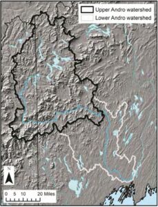
“The area covered by this Atlas is the transition zone and wilder northern part of the watershed, including parts of Coos County in New Hampshire and Franklin and Oxford counties in Maine. It encompasses the Androscoggin River watershed upstream of the Riley Dam on the Androscoggin River. This Atlas encompasses more than 2,445 square miles—more than twice the size of Rhode Island. This is the Great North Woods—a land of vast forests and undeveloped lakes, where moose roam and loons call out across misty waters. It is a land that echoes with the ghosts of old logging camps and keystone predators such as the grey wolf and mountain lion—an area rich in history and holding much promise for the future.”
Published by the Appalachian Mountain Club you can access a high resolution version here.
Share this page: