
[gview file=”https://courses.bowdoin.edu/digital-computational-studies-2430-fall-2014/wp-content/uploads/sites/52/2014/12/DIOTC-Final-Paper-web.pdf”]
All posts by lwang
Transect Walk – Countless Empty Benches: Exploring the Intersectionality of Urban and Nature
Having done the transect walk, I am more confident in my original ideas, which was already supported by my cafe ethnography.
- Portland has amazing natural beauty, that could be better utilized, appreciated by more people, and to a certain extent, capitalized.
- Amazing and gorgeous views, but few people get to enjoy it, which is pretty evident from all the empty benches. There is definitely more potential for higher utilization rates — even the designers of the park would agree!
- Infrastructure could be designed near the Waterfront in ways that complements and preserves Maine’s natural beauty, which would attract a greater population to the area.
- I have been told that during Canadian Thanksgiving, Canadians take ships to Portland and dock at Old Port. However, constructing a pier/casino complex in the East End would be perfect. It is the closest spot in Portland City to the ocean. Visitors can visit the complex and cash can flow into the city without disrupting other parts of the City.
- 295 is really close to many residential neighborhoods, and noise pollution can become troublesome.
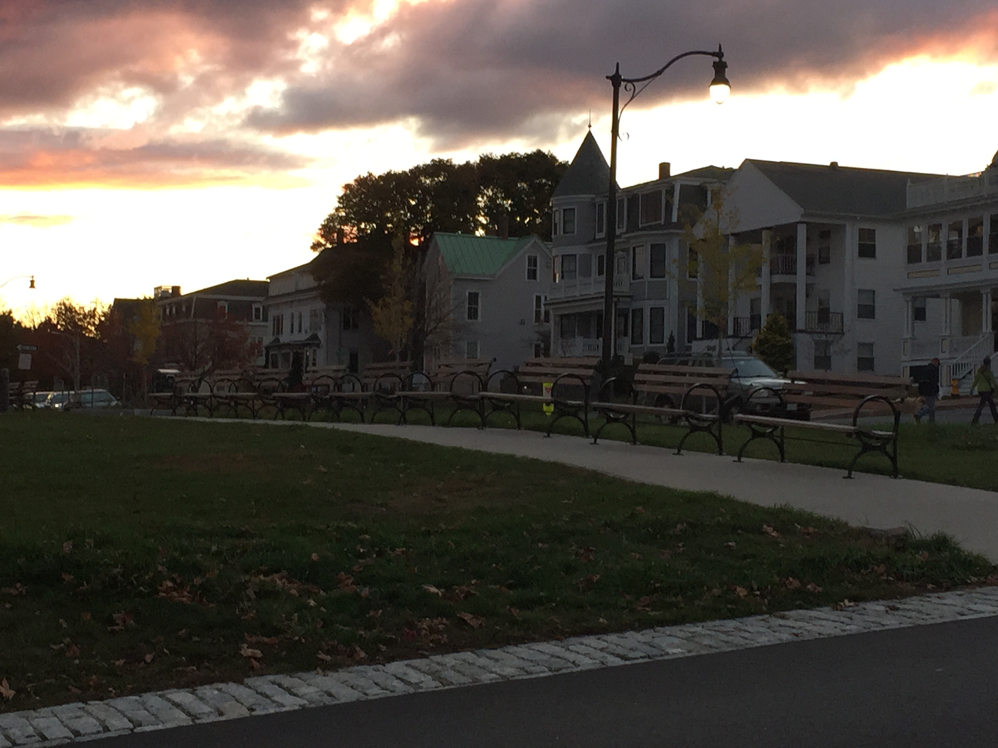
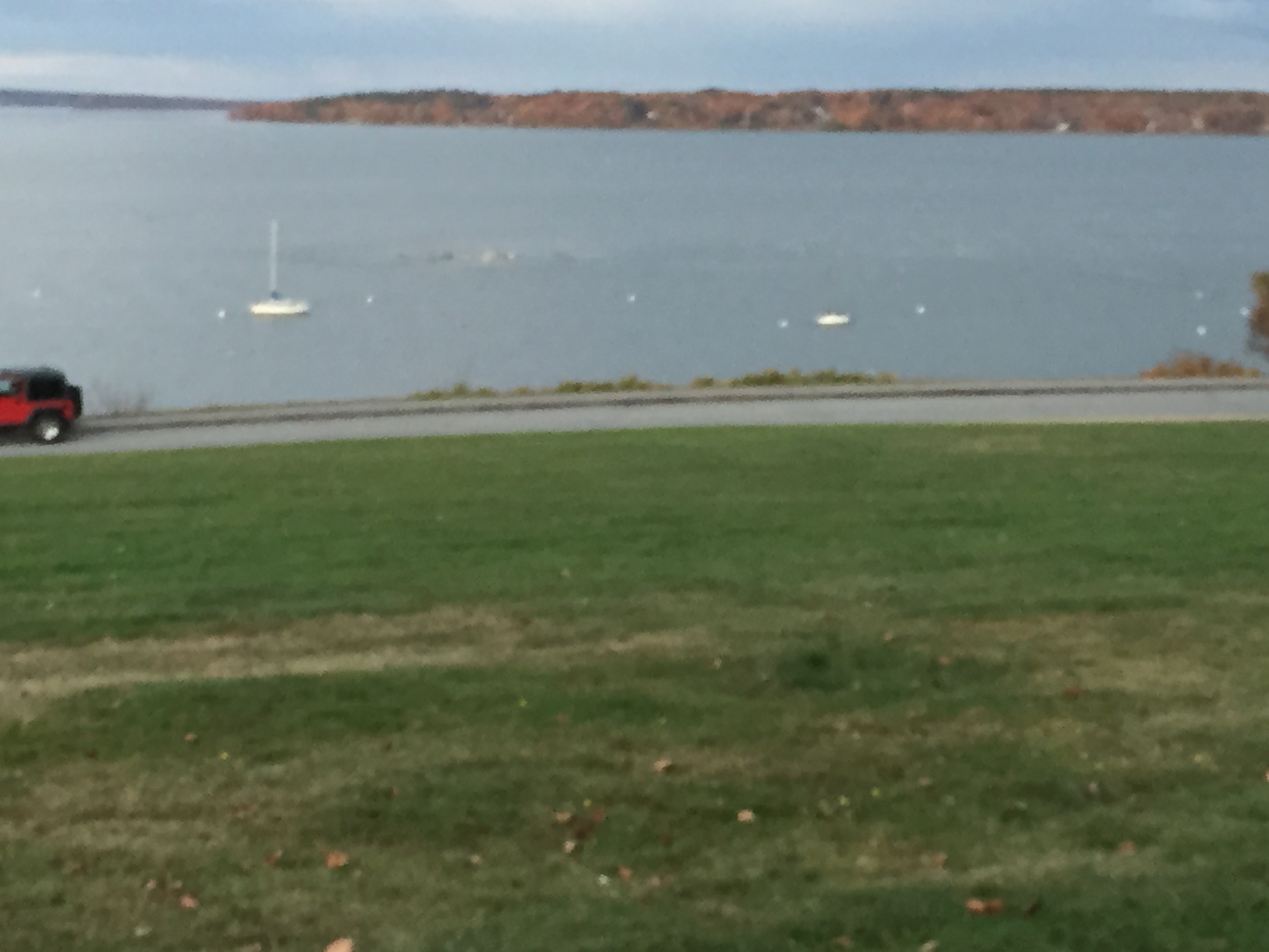
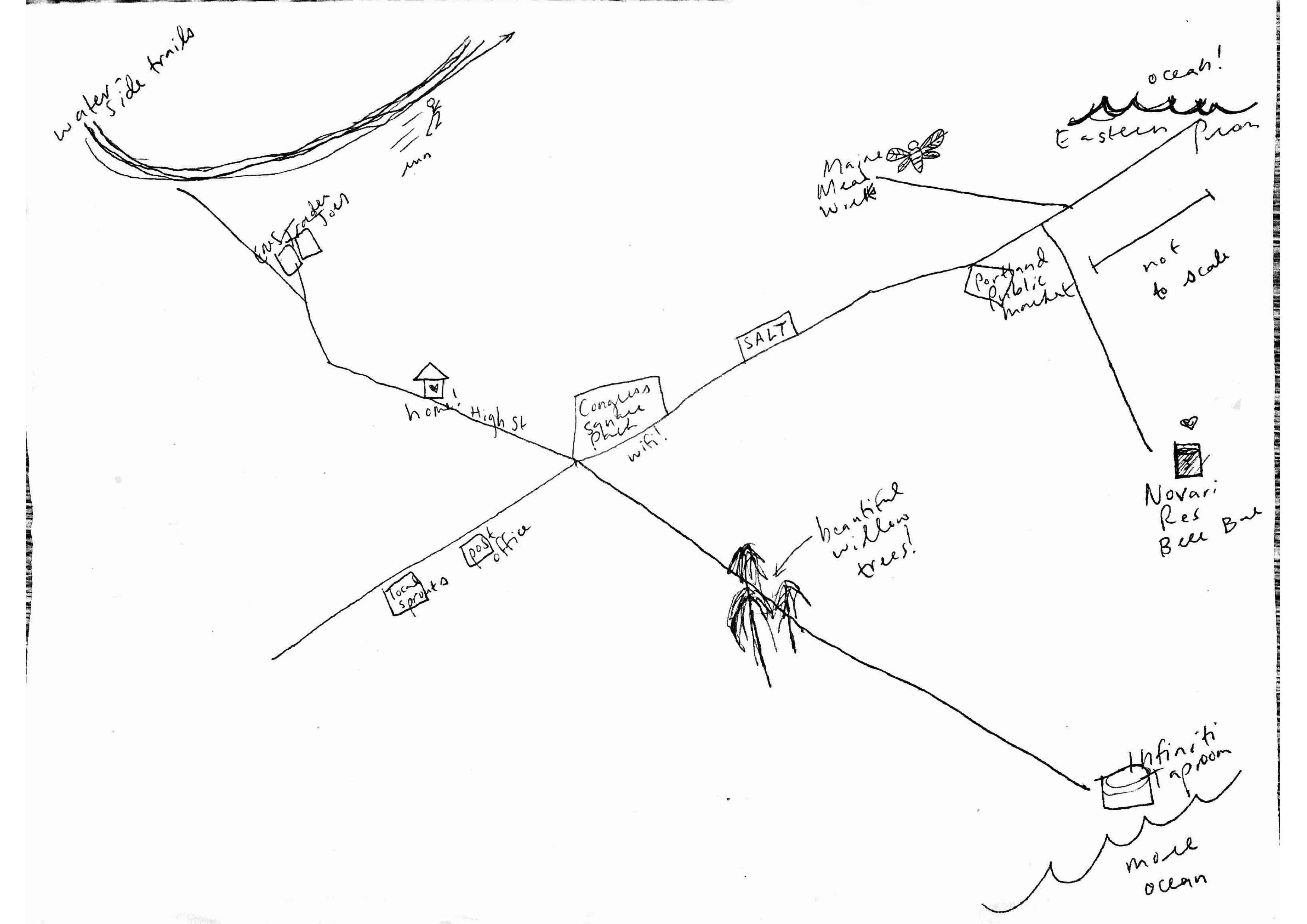
Transect Walk: Eastern Promenade
- The neighborhoods on my way to the East End looked nicer than when I was on the West Side. In fact, I was pretty impressed by the entirety of Fore Street — very commercial and lively.
- Toward the south side I see some people and a lot of dogs. Though through out my entire walk there seems to be a lack of dogs waste disposal facilities.
- No public transportation seen near the East End, although there a lot of road access approaching the waterfront.
- Benches every 7 yards but there all empty, as can be seen from the photos below. All benches have different name plates on them, which is kinda cool.
- Pretty nice park, breathtaking scenery, as you can probably see from the pictures. No fences surrounding the park area. No homeless people seen. Just no living things around me.
- Do not really see many light posts in the park, not really designed for recreation after dark, eh?
- Huge parking lots. All empty.
- There is a playground with no children.
- A jogger just passed me!!!
- Many multi family houses. So there should be a sizable population in the community, which does not make sense considering I have been seeing nobody outside. The houses do not seem entirely occupied.
- I can hear sounds of the highway (295) throughout the walk. Having the 295 so close by and above ground creates serious noise pollution, which definitely impacts the values of adjacent properties.


Empty signs?? Infrastructure not well serviced around here I see.

Coordinates:
- Lat: 43.6655; Long: -70.2415
- Lat: 43.6651; Long: -70.2401
- Lat: 43.6667; Long: -70.2411
- Lat: 43.6674; Long: -70.2419
- Lat: 43.6678; Long: -70.2423
- Lat: 43.6683; Long: -70.2432
- Lat: 43.6695; Long: -70.2451
- Lat: 43.6697; Long: -70.2457
CAFE ETHNOGRAPHY
Local Sprouts Cooperative
After doing some field work through Cafe Ethnography and collecting some mental maps, I have reaffirmed my original ideas about improving infrastructure in Portland, Maine (more development projects to attract investment and population, such as building a casino). I have reached this conclusion from the following insights drawn from my ethnography and mental maps, below.
1) Lack of population. There does not seem to be enough people to sustain Portland’s service industry. This would also explain the empty prime location retail spaces still looking for tenants. It is not that businesses are not attracting people, but the fact that even a major thruway looks relatively empty. This would also explain higher prices in the cafe to help compensate for high fixed operational costs.
2) Lack of businesses. More business mean more tax income, which could go to aiding the Preble St people, along with funding many other public space projects that would make everybody’s lives better. It would also mean more job opportunities.
3:00 pm – The cafe is mostly empty, with only 10 patrons including myself. The cafe seems to offer a lot of options in addition to coffee and tea, including beer and drink specials. The prices tend toward the higher end of the cafes I have been to in Maine.
3:10 pm – The place does not look like it is well attended to. There seems to be only 2 staff working. I spot patrons waiting at counter for somebody to help them.
3:25 pm – I spot a couple dating, a female student texting, another female student with headphones on doing work, a mid-aged woman doing work on her laptop (all electronics have an Apple logo on them).
3:30 pm – Talked to 2 people who identified as queers: they loved the character of Portland and the sense of community, stating that it is not overwhelming.
3:50 pm – Decorations and vibe in general feels very “Maine.”
4:03 pm – Music : Something in the way he moves – Bobbie Gentry.
Lighting and mood feels organic in a sense. I also spot artwork of plants and animals. There is even a food map of Maine, something which I feel is quite relevant to our class. I should have taken a picture of it. I guess the cafe is really capitalizing on Maine’s distinct personality and why people chose to come here. Most furniture are made of wood, and even the floor is wooden.
4:05 pm – Just noticed there’s free WiFi— not really obvious.
4:07 pm – Music: Fancy – Bobbie Gentry.
4:10pm – Looking out, I observe little car traffic on Congress St, which is quite shocking considering all mental maps contained the road in a central artery position. The couple dating just got served food and are now eating.
4:15 pm – There is nobody in the children area.
4:25 pm – Pretty much the same crowd at the cafe. A guy came in by himself, and is eating a meal. The woman who was working on her laptop is now cleaning up and getting ready to leave. And then I just noticed that even without much staff attention, the place still looks pretty neat and clean. This might be suggestive of Portland residents being really considerate of others.
4:30 pm – I see a guy standing along in a corner reading a book? Questionable what he is doing.
4:40 pm – I feel the lighting and vibe makes me become negligent of time, though I am not sure if time feels faster or slower. Or maybe it has something to do with the music — Amy Winehouse is playing at the moment.
4:50 pm – There is seemingly more traffic outside, though I see way more pedestrians.
4:55 pm – There is a giant “For Lease” sign outside at 648 Congress St. Its neighbor, 652, looks empty too. The retail situation on Congress St doesn’t seem so great.
5:00 pm – Traffic outside have started to die down.
5:10 pm – A couple of people are walking around while talking on their phones, though not disturbingly.
5:15 pm – I just noticed there are a lot of christmas lighting, a Social Justice board, and a giant wall outside of bathroom dedicated to ad and event posts. The information seem to be very diversified— I see events and opportunities catered to a variety of different interests.
5:20 pm – Most of the people in the cafe when I entered have already left, except for the female student working, and the couple on the date still dining.
5:24 pm – I observe many single males come in ordering meals at this point.
5:26 pm – I also just remembered that almost everybody I talked to in the cafe mentioned Preble St. as being the sketchy area that people have to detour around to get from Old Port to Whole Foods and other business on Marginal Way.
5:28 pm – I have seen a bus pass through Congress St. roughly every 10 min. All the buses look pretty empty. Directly across the street at 650 Congress, is a “she-bear” gallery?
5:30 pm – People outside don’t seem to be walking fast at all. Everybody looks like they are just casually taking a walk. Most passer-bys look young and hippy, or older and badly groomed.
5:32 pm – As I am leaving, I notice a piano that’s not being utilized (don’t know if you are allowed to). By the way, how does a cafe become emptier at 5:30 pm than at 3 pm??!!
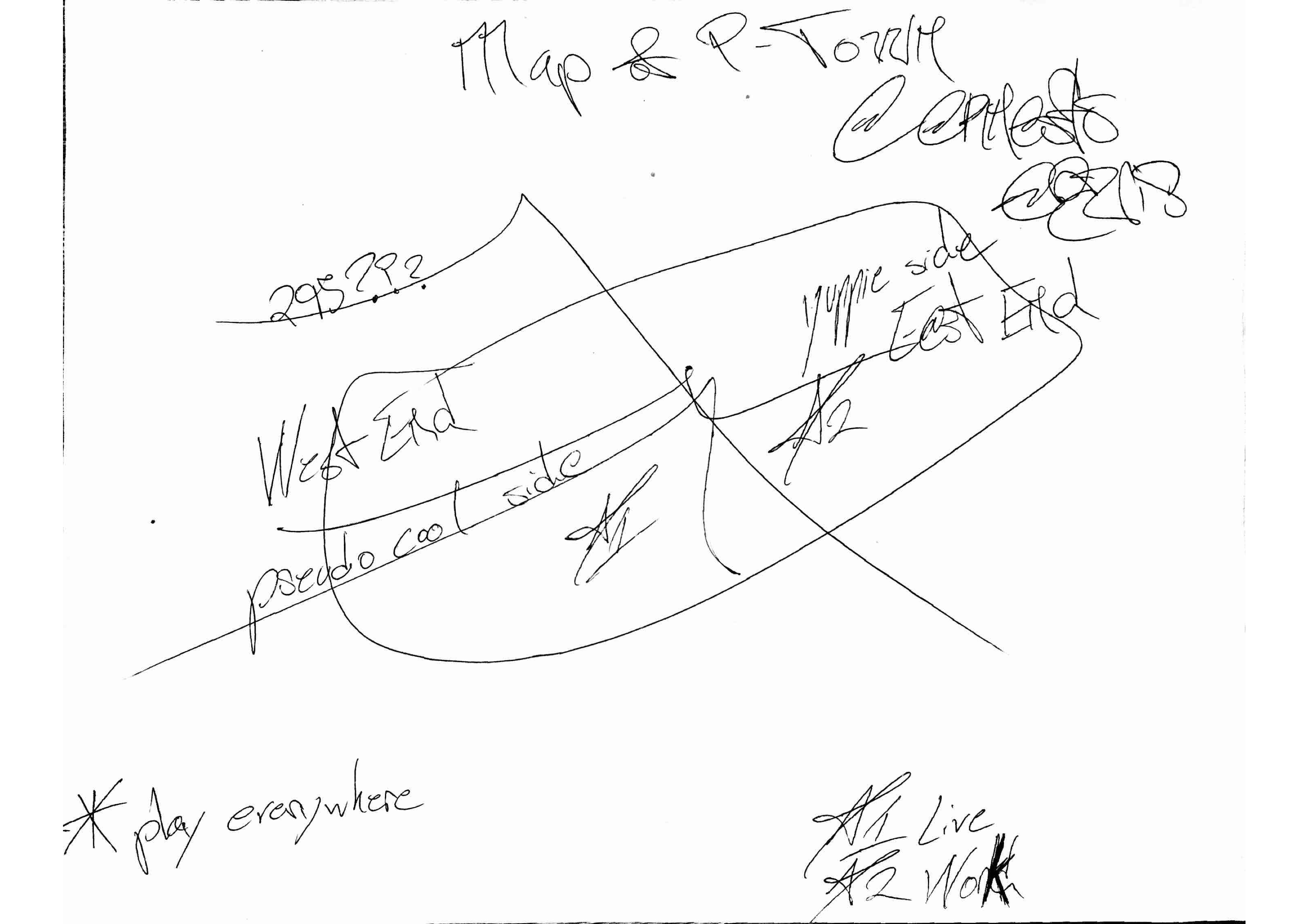
Map 1: Parker, 26, in Portland for 3 years, identifies as male, lives in South Portland, works in retail at the Maine Mall. [email protected]
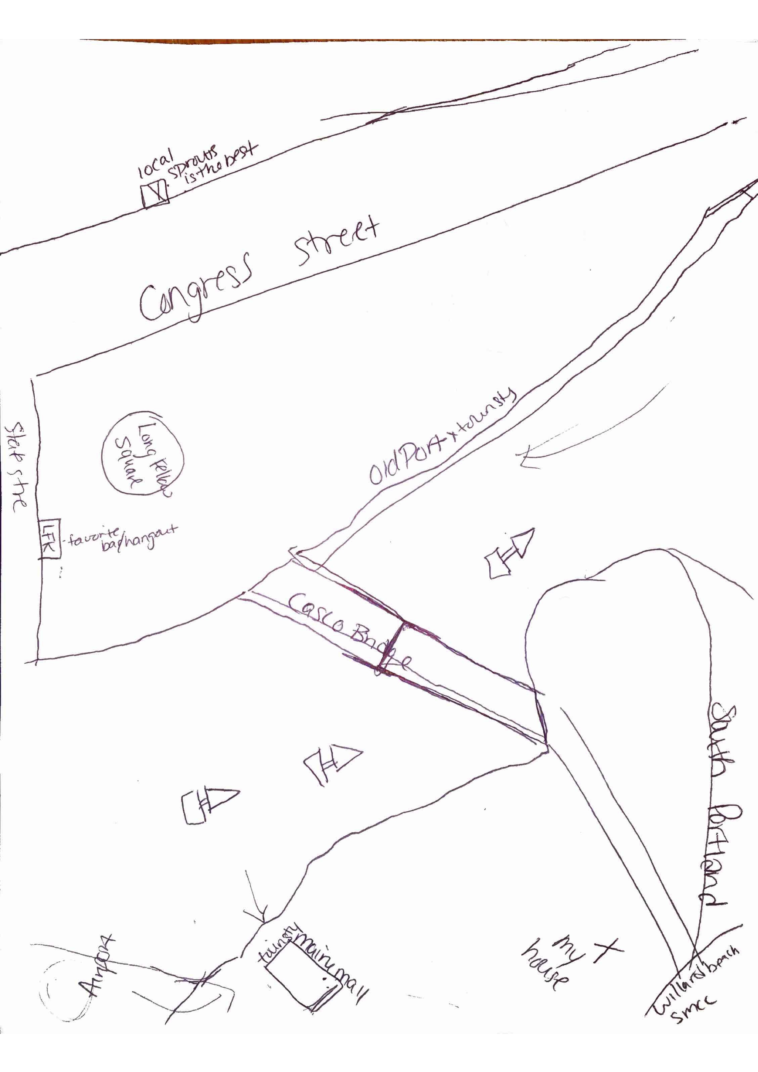
Map 2: Lahana Palehcia, 19, Female, Housekeeper, in Portland for 1.5 years, lives on Congress St, [email protected]. Uses the Portland Bus System extensively.

Map 3: 24, female, student, in Portland for 3 months, lives on High Street, wishes there were more public shuttles to get to wilderness areas.
Map 4: Erneok Moreno, 32, male, in Portland for 2 months, lives in West End, [email protected].
Separation as Increased Access: “Smarter” Flow in Traffic Infrastructure
Both in-class discussions and readings regarding infrastructure involve debate about the “right to infrastructure,” and most prominently is the constant tension between pedestrians and cars— which should be prioritized in urban infrastructure planning. In his essay, “Traffic in Democracy,” Sorkin talks about how the city “organizes its prejudices and privileges physically,” specifically exemplifying how New York physically prioritized motor vehicles in its closing down of 50th Street pedestrian crossings. [1] Many have questioned New York’s decision, stating that such measures does not create equal access to the City.
First and foremost, the “equal” in “equal access to the city” needs to be qualified. “Equal” should be within relatively similar contexts. Surely, a Manhattan resident has more access to Midtown than a Long Islander. At this point, one may argue that even within Manhattan, motorists and pedestrians do not receive equal access to the roads. The equality here deserves qualifying, too. “Equal access” should mean that motorists receive equal access to the motor lanes, and all pedestrians should receive equal access to the walking lanes. Cross-comparing motorists and pedestrians is meaningless, as I will argue in the next paragraph.
Before I discuss the hierarchy between motorists and non-motorists, I would like to highlight that these two groups are not mutually exclusive— a person decides which transportation method he will use based on his specific situation. For example, if I travelled from far away, or if I am in hurry to reach my destination, I may choose to drive. If I intend to get more exercise, or I simply am not in a hurry, I may choose to walk. The decision of being a motorist or not is more dependent on which gives the person more utility. Surely a person in a hurry should not be waiting for a person that is not.
So how to promote smarter infrastructure and city experience for all if the road is not meant to be divided equally between cars and pedestrians? My suggestion is to have dedicated passageways for each. Motorists travel from further distances and prioritize saving time, so a couple major roads and thruways can be dedicated for their usage, with big parking lots accessible near the thruways. At the same time, other roads should be converted to exclusive pedestrian usage. Separating different forms of traffic based on their different speeds and needs will improve the flow and efficiency of the city, while also minimizing congestion. Sorkin describes the “flow” in New York, and how that resulted in slower moving bodies deferring to faster ones. [1] However, if we separate them, no group would have to specifically defer to another. And this is definitely something Portland can implement with its current roads system.
[1] Michael Sorkin, “Traffic in Democracy,” in The People and Space Reader, ed. Jen Jack Gieseking, et al (New York: Routledge), 2014, 411-415.
Mobile Apps and Bus Stop Screens: The Intersection of Homelessness and the Smart City
As we have seen during our class trip to the Preble St. Project in Old Port, homelessness is a pressing issue in today’s cities. Moving these people from the public spaces into warm beds not only serves the common good, but also is something we can potentially achieve through adopting smart urban measures.
One of the major problems of homelessness is that they take up parks and roads among other public spaces, spaces that are designed to be shared among all people, not just a select group. Neil Smith, in his essay, even goes as far as to describe the homeless residing in Tompkin’s Square Park in 1991 as having “stolen” the park from the community. [1] Loosing public space is only one of the ramifications of the relative inaccessibility of urban housing. Increased crime and violence, and deteriorating hygiene, city’s public image, and tourism are also problems that often accompany inflating homelessness.
Addressing the creation of “smart cities,” Crowley et al. presented the idea of creating a “system of systems” using automated sensors that are all intricately connected, in order to save resources and maximize efficiency. As an example, he illustrates reducing energy usage in an office building by 26% through “Twittering” workers about specific items that are unnecessarily consuming energy. [2] Albeit being very groundbreaking with the potential to drastically change human life in the near future, I hold a couple reservations in supporting Crowley’s vision. First of all, computer systems are not necessarily robust— specifically in the sense that the system security could most always be breached and compromised. At this stage, the human kind has also been known to have designed artificial intelligence with functioning conscience. It is a terrifying thought to imagine that AI could possibly remote control our lives, seamlessly. Thus, I believe that Crowley’s idea deserves further ethical discussions. The second downside to his application of “smart city” ideas is the enormous up-front cost for the systems and sensors, things that the majority of the population might not willingly pay for.
I have been thinking about where issues of homelessness and building a smarter city could intersect. And the result would be an app that can actively display the number of available beds at shelters and other community centers. It should also contain simple-to-follow guides on how to apply to public housing and even on what do and where to ask for help in the event of homelessness. This app can even be installed on interactive touch-screens embedded in bus stops.
[1] Smith, Neil. 2014 [1996]. “‘Class Struggle on Avenue B’: The Lower East Side as the Wild Wild West.” In The People, Place, and Space Reader, edited by Jen Jack Gieseking, et al, 314-319. New York: Routledge, 2014.
[2] Crowley, David N., Edward Curry, and John G. Breslin. 2014. “Leveraging Social Media and IoT to Bootstrap Smart Environments.” In Big Data and Internet of Things: A Roadmap for Smart Environments, edited by Nik Bessis and Ciprian Dobre, 379-99. Springer. http://link.springer.com/chapter/10.1007/978-3-319-05029-4_16.
Progressing Public Spaces in Portland: Security and Privatization
Public spaces are invaluable in that they are capable of converging people from different walks of life. Mitchell writes, “in a world defined by private property, then, public space (as the space for representation) takes on exceptional importance.” [194]1 Public spaces can serve a myriad of purposes, including but not limited to spaces where people can perform recreational activities, play sports, enjoy serenity, connect with nature, and connect with other people. To serve these purposes, Portland need spaces which grass fields, lots of seating areas, and open plazas.
The common good can also be served through maximizing usage of these spaces, while prioritizing security, as to ensure that public spaces do not become magnets for crime. This has long been a concern in New York City, as we discussed in class a girl has been gang raped in Central Park, while Low observes, “fear now pervades the postindustrial plazas of New York City.” [165]2 Surveillance should be everywhere, and police stations should be nearby as to assure quick response times.
When designing its public spaces, Portland needs to consider the commercial and privatization potentials of the space. The argument for this is that public spaces needs a high level of utilization rate and maintenance. One of the reasons that current Portland parks are not currently well designed and kept might be due to the lack of funds. This is why having corporate and commercial presence in the parks would benefit Portland’s community. Initially commercial events would increase the parks popularity and visibility. And then, more people would utilize the parks when the events are not in session.
[1] Mitchell, Don. 2014. “To Go Again to Hyde Park: Public Space, Rights, and Social Justice.” In The People, Place and Space Reader, edited by Jen Jack Gieseking, et al, 192-196. New York: Routledge, 2014.
[2] Low, Setha M. 2002. “Spaces of Reflection, Recovery, and Resistance: Reimagining the Postindustrial Plaza.” In After the World Trade Center: Rethinking New York City, edited by Michael Sorkin and Sharon Zukin, 163-72. New York: Routledge, 2014.
Revitalizing Portland: Population growth and acceleration
My initial list of 5 recommendations for Portland, Maine are as follows:
1. Integration of Back Cove to Old Port/Downtown area;
2. Statuesque icon/landmark;
3. More open waterfronts;
4. Less seasonal attractions that can boost tourism all year round, such as casinos, or other forms of one-stop entertainment center;
5. Green roofs.
After careful consideration and contemplation about long-term benefits, I have decided the two most urgent suggestions is to initiate the Back Cove-Downtown Project, and the Entertainment Center Project.
One of my biggest considerations is Portland relatively low population. Portland’s population has been relatively steady for the past years while most cities’ population have grown considerably. A lot of the other ideas our classmates have come up with, such as better public transportation, would readily come into place with increased population and increased demand. A greater population would also increase Portland’s competitiveness and service-related industries, among many other positive influences.
Currently, Portland’s population shows seasonality—booming tourism during the summer, with much less inhabitants during the winter. Portland needs attractions that are not affected by different seasons, and a big casino/entertainment center would serve this purpose. It would attract tourists and visitors all year round, while also becoming a significant contributor to Portland’s economy, boosting tax income and potentially creating tens of thousands of jobs. The complex could also feature shopping malls, restaurants, movie theaters, hotels, etc, to become an essentially a one-stop resort destination in New England. This also works well with Maine’s vacationland image and strategy. If built aesthetically pleasant, the complex could also become a statuesque icon/landmark of the City.
Portland downtown is a peninsula, with I-295 as the limits on land. This creates a confinement that in turn limits Portland downtown’s possibility of expanding and developing. Looking at Downtown Boston, which is similar to Portland in many ways, we can see the Boston Downtown does not have a thruway barrier, and other regions on the peripherals of the center have emerged as commercial centers, such as Back Bay, Newbury St, Prudential Center, etc. Major thruways like the I-93 and I-90 have gone underground to create space for city development and increase the city’s walkability.
Back Cove is geographically adjacent to Old Port, though separated from the latter by I-295. Bringing I-295 underground would not only allow Portland Downtown to continue grow, but would also open access to Back Cove from downtown, and also possibly integrate Back Cove into the Downtown region, which would also open up a huge waterfront for increased public access. Reclaimed land can also be used for valuable waterfront development and high value real estate. It can also be used to create a giant “Central Park,” surrounding Back Cove, for Portland. More housing and development will also in turn attract more population to Portland.
Links or Rifts: Transportation Infrastructures vis-à-vis City Spaces
Before I would visit a city, I would always study its map, try to identify the places on my itinerary, and note the spacial references that will help me navigate the new city. Maps have always appealed to me— I would stare at them for a long time, tracing roads and thruways, wondering which dots they connect, and thinking about how the current road system have supported (or hindered) the growth of a city. And thus, the lines on the maps—the roads— have played a significant role in my mental visualizations of the city. In my mind, I have always defined a city’s sophistication in terms of the density of its roads network— cities tend to have very dense road networks to transport the vast amount of population to its destination, while smaller towns and villages (non-cities) have simpler road networks. I am very excited to have the opportunity to study a city and its transportation infrastructure.
The Hayden reading really made me think more deeply into the issue of space, specifically the “politics of a space”— social demographics, emotional attachments, and its character. These are some very important topics that are not readily seen on common visual representations of cities, such as Google Maps, but nonetheless important. Thinking about the “politics of spaces” in relation with the transportation infrastructure of a city, I realize their connections are very much intricate. On one hand, transportation systems foster the creations and shaping of new spaces, through making spaces accessible that were once not; however, on the other hand, certain links (such as 12-lane highways) can also act as iron wall that separates spaces that were once connected, creating rifts that are unproductive to the development of the city as a whole.
Thinking about my proposed topic in the relationship of transportation infrastructure vis-à-vis urban spaces, I realize the cities I have been living in have always been influenced by this issue— from how satellite towns emerged with the construction of new roads, to how the existence of a circular beltway bolstered a geographical notion of “inner city” that influenced real estate prices. I feel similar patterns can be seen in Portland, Maine, as several Portland residents I talked to all raised the importance of I-295, as they referred to Portland Downtown as “everything that is inside I-295.”