https://drive.google.com/folderview?id=0B2vvrbJ-N-zDUE5UQksxMFNXZUk&usp=sharing
Rebuilding and Reutilization: Revitalization of Portland Piers
Research Topic
This paper argues that one of the most crucial and feasible infrastructure projects for the City of Portland, Maine, is the rebuilding, repurposing, and ultimately the revitalization of piers in the Downtown or “Old Port” district. The utilization of the piers through the development of public green space (a “pier park”), and residential and commercial real estate would have the most direct economically and socially beneficial impact on the city, specifically the Old Port. I propose redeveloping the properties into multiple public and private spaces with the intention to alleviate the concerns of a lack of public space and underutilized valuable waterfront real estate. This paper argues that the implementation of technologically forward-thinking power systems as well as data collection and monitoring systems will push Portland into the “Smart City” era. Portland has recently revamped its rules and regulations regarding the existing piers, and several businesses have capitalized on the exclusive real estate, but much more needs to be done to complete the transformation of Portland’s Old Port piers.
Approach to the common good for the city
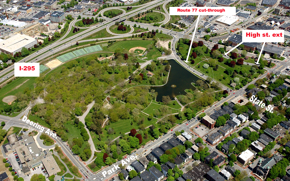
The piers of the Old Port are some of the most feasible locations to implement changes benefitting the common good, due to their current run-down condition and proximity to the highly trafficked and desirable commercial region of the Old Port. The proximity of the piers to the burgeoning and gentrifying neighborhoods of downtown Portland promises increased public demand and economic investment. The redesign of the piers as an extension of the existing waterfront park system, new housing development, and business and restaurant center would directly benefit the Common Good by encouraging physical wellness and economic development. The new pier park would be a resource for free physical (and subsequently emotional) wellness to all visitors. Office space, restaurants, and retail shops would build the local economy, due to the piers’ proximity to the downtown neighborhoods and business district of Portland. Currently, however, they offer no access, claim, change, or ownership to those of lower classes.[1] A seafood market, arguably pricey, and a high-end tote bag shop were noteworthy businesses currently inhabiting one pier. Another pier has only a few pricey apartments. My proposed plan would at least extend the rights of access and wellness for those less privileged.
Approach to the smart city
Sensors and networks of sensors are a “key requirement for the delivery of Smart Environments”, but they are disruptive to install on existing systems/buildings.[2] Powerwise Systems, a Maine business, was started specifically to produce the types of sensors and monitoring equipment able to be installed into pre-existing infrastructure. The systems provide “circuit-level electrical monitoring; remote HVAC and lighting controls; building environment monitoring; performance measurement for PV, solar thermal, heat pumps, energy-recovery ventilators (ERV/HRV); and a variety of flow, fluid level, water, and gas monitoring.”[3] Access to this knowledge would encourage less wasteful behavior, thereby creating a healthier environment and benefiting the common good. It seems obvious that, with these systems already designed and able to be easily installed, the City of Portland should invest in systems. The systems should be installed in City buildings; businesses can nail down machines, practices, or groups that are particularly inefficient; landlords can pinpoint wasteful renters, and even specific rooms that need work; and individual homeowners can control their living spaces from-away to minimize their effect on the environment and the strain on their wallet. The rapid progression of technology is now making it possible to control and monitor these systems from a mobile device, encouraging around-the-clock watchfulness and accountability. However, with a newly installed Powerwise monitoring system comes large-scale data collection and analysis. According to Crowley, Curry, and Breslin, data aggregation from separate existing public systems is a logistical nightmare.[4] In addition, data analysis of citywide, national, international, or global data sets is a monumental task requiring lots of time on specialized high-computing systems run by data and statistical specialists.[5],[6] Ultimately, this means that the tremendous amount of data produced by the system of sensors will need to monitored for specific measurements, trends, or anomalies, with the caveat that much of the generated data from these sensors will go unused for years before computing power rises to levels able to handle current and past data simultaneously.
Literature review
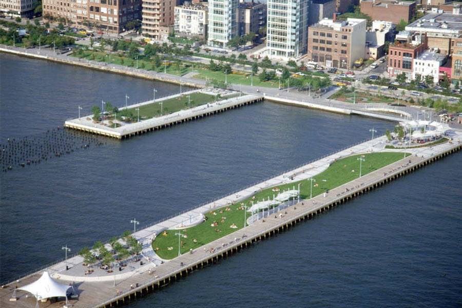
There has been much discussion around the topic of redeveloping and reutilizing existing infrastructure, a small selection of which I will touch on in this short proposal. In his essay “Traffic in Democracy”, Michael Sorkin describes the American growth ideal of “sprawl without end” as having “escaped rational management.”[7] The Downtown of Portland has a different problem, however; located on a peninsula, sprawl and outward growth are not possible. In this case it becomes crucial either to build up, as most large cities opt for, or to repurpose existing infrastructure. This paper points to the London Docklands and New York City’s Hudson River Park as two notable examples of rebuilding, reutilization, and, ultimately, revitalization.
In NYC it is clear that space limitations drove development up; but NYC was obsessed with “NEW, BETTER, DIFFERENT!” Portland and many other cities don’t have the capital, capabilities, or desire to follow that building plan, and should think instead about how to reuse existing infrastructure. Hudson River Park in NYC has been heralded as “the model for New York City parks to come” and “the most significant new public space since Central Park.”[8],[9] Built out of the failed Westway highway project, development of the park was started in 1998 and is approximately 70% complete today.[10] Transformed from decaying piers and parking lots, it is the second largest park in the city after Central Park, encompassing 550-acres and offering over thirty different activities.[11] It is also the largest waterfront park in the United States and hosts 17 million visitors annually.[12]
The Docklands in the outskirts of London were “the old spaces, liberated from their traditional activities and lying derelict and unwanted, [that needed to] be recycled to meet the needs of the new economic world.”[13] Slow abandonment after changes in shipping vessel size rendered the docks obsolete; it took tens of years, millions of dollars, and a bevy of government and public groups to rebuild and revitalize the Docklands. The region now houses the “engine-rooms of twenty-first century business.”[14] In fact, due to the many banks and other economically important businesses in the area, Canary Wharf now rivals London as a financial stronghold.[15],[16] The current economic importance of the Docklands, the region’s architectural transformation from rough industrial and manufacturing buildings to clean-cut skyscrapers of international business, and the discovery of the necessity of cooperation has made the 30-year development a case study of urban revitalization. Against all odds, the London Docklands “wasteland” has become a “Wall Street on Water.”[17]
Setha Low argues that the privatization and commercialization of public spaces is necessary to their future and points out that they induce an expected level of class in the public space.[18] By allowing more non-marine groups and providing economic incentives for businesses, Portland could also develop the piers into an exceptional extension of the already existing waterfront park system. While this privatization may seem to subvert the “right to the city” as Lefebrev puts it, or “the right to sleep unmolested in a city park”, as Mitchell suggests, I argue that the piers as they now stand offer even less right to the underprivileged.[19] In their current ramshackle state, the piers are targets for tighter scrutiny and do not allow public access, excepting the road, thereby making it difficult for the underprivileged to access the waterfront or stake any claim in the space. By creating a public green space and improving the overall conditions of the piers, Portland simultaneously will provide an opportunity for the “right to the city”.
Rebuilding infrastructure requires more than clever engineering as Michael Sorkin tells us in his essay “Traffic in Democracy”: “It has to be thought through politically… rather than approached as merely a set of technical problems.”[20] Since the 1980s when condominiums were built on Chandlers’ Wharf in the Old Port, city policy has restricted development and occupancy to a working waterfront. However, given recent policy changes allowing “up to 45 percent of the ground floor to… non-marine tenants”, the door is slightly more open for other offices and businesses to move into these prime waterfront locations.[21] These business opportunities should be quick to be filled, but the marine spaces remain available due to a deflating ecosystem and therefore decreasing numbers of fishermen and other traditional Maine marine business. Fortunately, there is business called the New England Ocean Cluster proposed on the neighboring Maine State Pier that would fit the marine requirement and greatly benefit the region.[22] While this business would be a great boon for the piers and the City, this is only one of many available marine spaces, and much more needs to be done to complete the transformation of the piers. Ultimately, the redevelopment of the piers as public green spaces, as well as business and housing options, is the most feasible and natural next step in the growth of Portland and will be supported by a history of similar projects around the world.
Methods
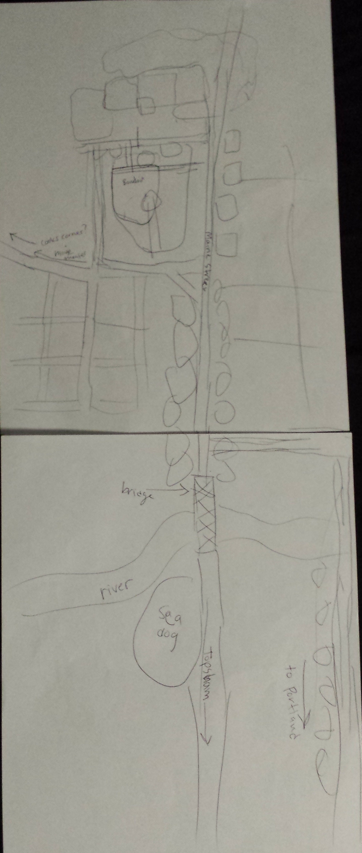
My methods of collecting data were threefold: First, data was collected on the revitalization of old buildings during a transect walk. Any structure that appeared to have an authentic skeleton or base, but with obvious new construction or renovations was marked on Map 1. Structures varied from residential-to-business converted properties to unintended utilization of old building space. I chose not to walk in the commercial section of the Old Port because this type of reutilized building structure (store or restaurant at ground level with apartments above) is very common. These streets have been distinguished on the map as generally well-repurposed and revitalized areas.
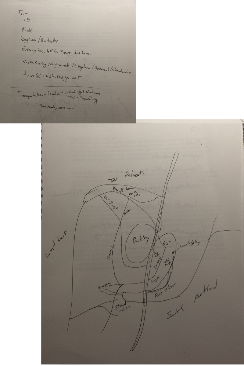
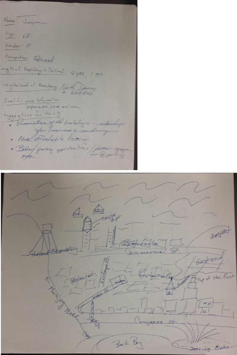
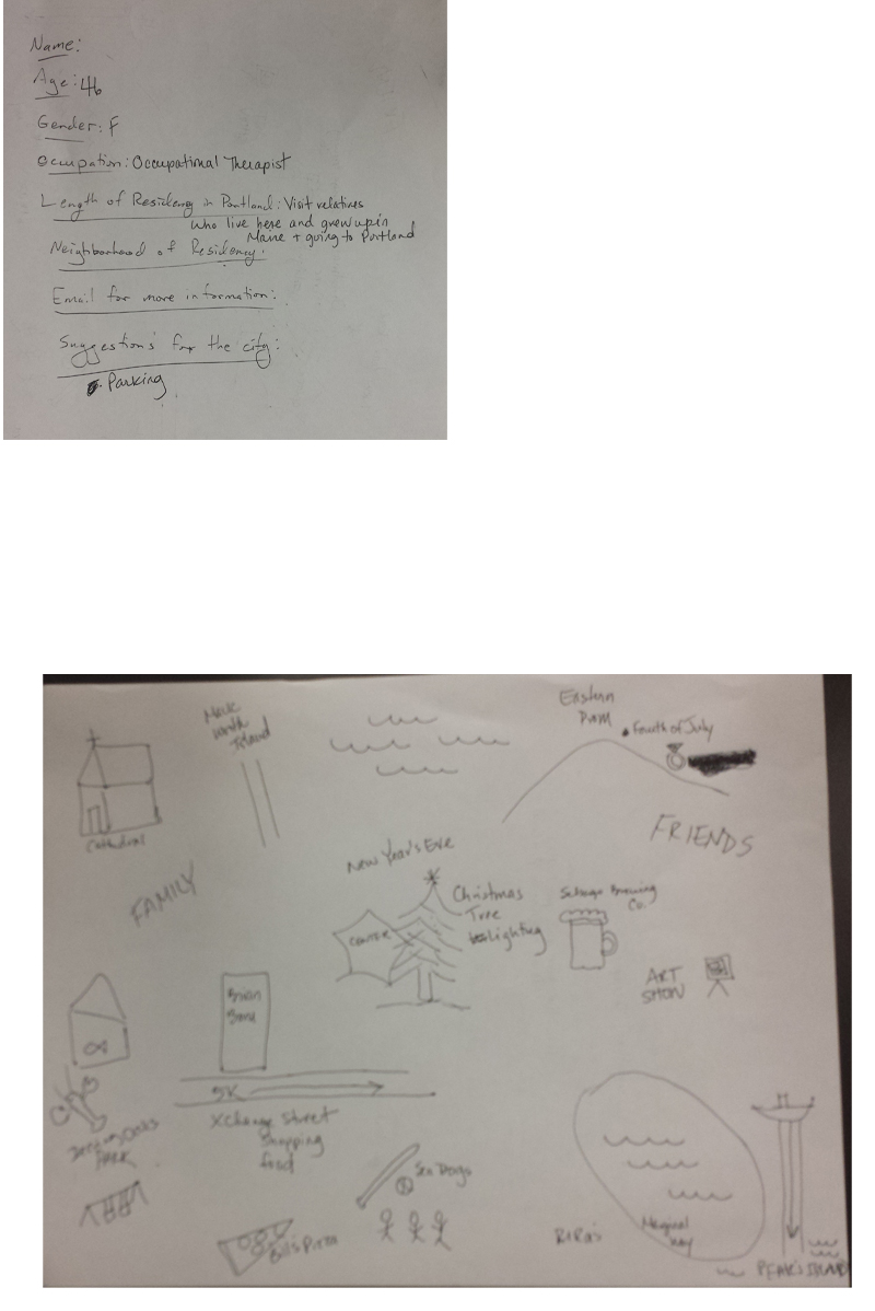
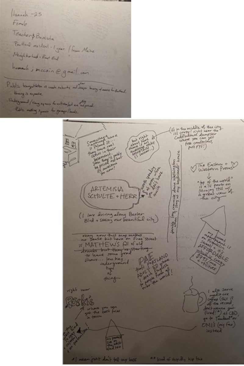
Second, every member of the Digital Image of the City class collected mental map data from Portland residents and commuters. The compiled mapping data provided a lens into the perceived needs of people of Portland as seen in Figure 1. The first part of the figure shows the distinct mentions of green space, waterfront access, economic incentives, art/music spaces, and the preservation of old buildings as a measure for possible resident interest in a proposed pier renovation and revitalization project. Additionally, the second part of the figure shows the prevalence of the geographic areas around the piers on mental maps.
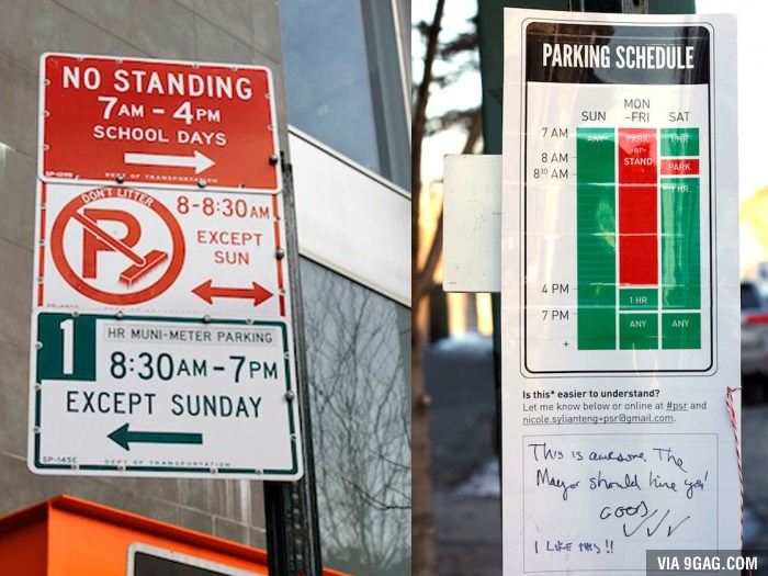
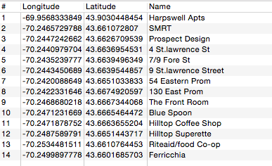
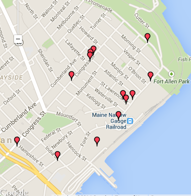
Third, commercial real estate data and residential real estate data was scraped from loopnet.com and zillow.com, respectfully, to build a database of commercial and housing prices in the Downtown. Visualizing this data shows the economic benefit of a water view and real estate closer to the water, as evidenced in Map 2, and the lack of available residential real estate, as evidenced by Image 1. Additional geographic data on green space from the City of Portland allowed the creation of Map 3, which demonstrates the need for the continuation of the waterfront park system. The map displays the green spaces with a buffer zone of five hundred meters, or about one-third of a mile, a comfortable walking distance for any age.
Findings
There is a clear need for these developments, as evidenced by comments from two mental map participants; one participant suggested “Preservation of old buildings – redevelop for business and residency”, while another participant suggested “[Affordable] underground/young spaces for activism and art” and “public meeting spaces for groups/bands.”[23] I found that most of the spaces I saw on my transect walk were restaurants and businesses that necessitated redesigned spaces. I also found that many houses on the Eastern Prom have undergone repairs to make the expensive houses worth more as multiunit apartments or condos. In addition, the fact that the real estate data demonstrated an increasing cost of commercial spaces close to the water implies a desire for office and business spaces, just as the lack of available residential real estate suggests competitive desirability and the need for more spaces. Finally, the proximate green space allows one to visually understand the necessity for a waterfront recreation area, extending the existing park system along Back Bay and the Eastern Promenade.
Reflections/discussion
Portland is a city that likes to stick with its heritage and is restricted by space limitations, but yearns to progress into the future. Repurposing buildings is a fantastic and fascinating use of existing infrastructure because it requires fewer materials and creates less waste, while revitalizing the look (and often purpose) of the building. I propose transforming Portland Pier, Custom House Wharf, and 68 Commercial Street pier, three run-down, mostly dilapidated piers into public green space and commercial and residential real estate. In the beginning of Against the Smart City, Greenfield directly states that the way “city dwellers collectively understand, approach and use the environment around us” is rapidly changing.[24] Even though there have been issues in the past with new condos on the water, we now know the allure and value of those properties. Following the examples of the Hudson River Parkway in New York City and the
|
London Docklands, we know the project is feasible.
As evidenced by Map 1, proximity to highly trafficked roads, retail and restaurant venues, and water views are large influencers of revitalization. It makes sense to continue the revitalization and reutilization of the Old Port on the piers because the underutilized space currently serves very few people and purposes, and provides very little economic benefit for the City, but has the potential for fantastic success, given the piers’ proximity to the commercial and restaurant district. Therefore, I propose the repurposing of commercial and residential buildings, and development of public green spaces, as a method for economic and infrastructure revitalization.
Figure 1 demonstrates the potential support for my proposal, as measured by residents’ specifically voiced concerns in interviews and noted locations on their mental maps. Fifteen of the one hundred residents specifically and uniquely pointed out one of the categories my proposed pier revitalization project would address, namely access to green spaces and the waterfront, economic incentives for businesses, spaces for art and music, and the preservation of old buildings. Exactly half of the residents interviewed chose to note the waterfront as an important feature of Portland on their mental map, while slightly more than one-fourth mentioned the Old Port/Downtown and/or the main waterfront street of the Downtown, Commercial Street. These responses indicate a strong level of interest and motivation by
|
Portland residents to enhance the Downtown and waterfront areas.
As seen in Map 2, there is clear economic benefit of water views and lower Downtown real estate in Portland for office and retail spaces. This data suggests the potential economic benefit of new real estate development on the piers, with leasing prices upwards of $30 per square foot. A rough estimate of the area of the three piers is 280,000 square feet. Assuming one-quarter of the pier is used for commercial real estate, there are two floors in the building, and an average price of $30 per square foot yields a conservative estimate of $4.2 million in taxable leasing revenue per month. This figure does not even take into account the revenue generated by those businesses and their employees eating or shopping at other nearby businesses, a further
|
infusion of hundreds of thousands of dollars into the local economy.
|
Image 1 expresses a lack of residential real estate in the Downtown, and shows that the rental prices are comparable to elsewhere in the city. As the city continues to gentrify and the price of housing continues to rise, there will be an increased demand for housing options, especially in close proximity to areas of employment. The piers provide an optimal opportunity to nip this situation in the bud. With their relative proximity to the majority of commercial and business jobs in the City, and available floor space for housing, the piers offer a solution to Portland’s expanding working population. An estimation of monthly taxable residential real estate (assuming one-quarter of the pier, two floors, at an average rental rate of $2,500 per month per 1,400 square feet) yields $250,000 in taxable revenue every month, and doesn’t take into account the hundreds of thousands of dollars spent locally in the Downtown by residents of the real estate.
|
As evidenced by Map 3, there is a need for additional green space in the Downtown to allow access to the waterfront, provide pleasurable public space for visitors and citizens, and enhance the value of surrounding buildings. In pink is the Downtown area of Portland that is not within 500 meters of a public green space and the proposed revitalized docks are in yellow. While understanding that creating public space has no direct economic benefit for the City, there are clear correlations between access to open, natural space, including a pleasurable waterfront, and workplace productivity and community happiness and health.[25], [26], [27] Additionally, creating a new public space would require vacant land, not often available in the City, especially in residential neighborhoods. Therefore, it would benefit all local businesses, residents, and the common good of the City to continue the already existing and well-used bike path and public green space along the waterfront, while utilizing the currently vacant pier land.
With the assistance of the Portland City Council and public support, one may be able to make the case for a non-typical marine institution such as an aquarium or seafood restaurant, or a space capitalizing on the water and benefiting the common good such as a park and ice rink to inhabit the lesser-used marine 55 percent. This policy change may be a make-or-break factor in the reutilization of the piers, since the existing policy makes it very difficult for all the available land to be utilized to its full economic and common good potential.
Policy Recommendation
My policy recommendation for the city of Portland is threefold. First, amend the current 45-55% (general – marine) space use policy to include non-traditional marine uses over the entire pier system, instead of on individual piers or real estate blocks. Second, encourage economic investment in the physical infrastructure of the piers with tax incentives for repurposing the existing structure. And third, designate and mandate public green space on the piers to encourage residential and tourist interaction with the waterfront. By employing these policy recommendations, the City of Portland will create a new dimension of The Old Port filled with benefits for the local economy and common good.
Conclusion
The Old Port has a fantastic resource within its grasp. There is demonstrated optimistic public interest, positive economic value, a rich history of reutilization in the City, and public health and wellness benefits. In addition, there are a number of prominent success stories from other cities off which to base plans and gain knowledge. The City of Portland should redouble efforts to reutilize the Portland Pier, Custom House Wharf, and 68 Commercial Street pier as sites of residential and commercial real estate and public green space for the benefit of the local economy and common good
Bibliography
Bagli, Charles V., and Lisa W. Foderaro. “Times and Tides Weigh on Hudson River Park.” New York Times, January 28, 2012.
Bell, Tom. “Maine State Pier envisioned as site of incubator for marine businesses.” Portland Press Herald. Last modified October 17, 2014. http://www.pressherald.com/2014/10/17/maine-state-pier-envisioned-site-incubator-marine-businesses/.
Billings, Randy. “New Building on Maine Wharf Reflects Portland’s Changing Waterfront.” Portland Press Herald. Last modified August 7, 2014. http://www.pressherald.com/2014/08/07/new-building-other-progress-reshape-portlands-waterfront/.
“The Changing Face of London: London Docklands,” September 2012. http://bbc.com.
Crowley, David N., Edward Curry, and John G. Breslin. “Leveraging Social Media and IoT to Bootstrap Smart Environments.” In Big Data and Internet of Things: A Roadmap for Smart Environments, edited by Nik Bessis and Ciprian Dobre, 380-82. N.p.: Springer, 2014.
Frumkin, Howard, and Richard Louv. “The Powerful Link Between Conserving Land and Preserving Health.” Editorial. Children & Nature Network. Last modified July 1, 2007. http://www.childrenandnature.org/news/detail/the_powerful_link_between_conserving_land_and_preserving_health/.
Gillett, Rachel. “How to Stop Your Office From Zapping Your Productivity.” Fast Company. http://www.fastcompany.com/3029994/work-smart/how-to-stop-your-office-from-zapping-your-productivity.
Greenfield, Adam. Against the Smart City. 1.3 ed. N.p.: Do Projects, n.d.
Hall, Peter. “The City of Capitalism Rampant.” In Cities in Civilization, 888-929. New York, NY: Pantheon Books, 1998.
Hannah, and Joyce. Interview by the author. Coffe By Design, India Street, Portland, ME. October 2014.
How We Built Britain. “The South: Dreams of Tomorrow.” BBC. November 2012 (originally aired July 2007).
Hudson River Park Trust. “About Us | Hudson River Park.” Hudson River Park. Accessed September 2014. http://www.hudsonriverpark.org/about-us.
———. “Explore The Park.” Hudson River Park. http://www.hudsonriverpark.org/explore-the-park.
———. “Hudson River Park Act.” Hudson River Park. http://www.hudsonriverpark.org/about-us/hrpt/hrp-act.
“InView Building Monitoring and Energy Management Solutions.” PowerWise Systems. http://www.powerwisesystems.com.
Ivy, Robert. “Waterborne City.” Abstract. Architectural Record, October 2009.
Low, Setha M. “Spaces of Reflection, Recovery, and Resistance: Reimagining the Postindustrial Plaza.” In After the World Trade Center: Rethinking New York City, edited by Michael Sorkin and Sharon Zukin, 164. New York, NY: Routledge, 2002.
MacLeod, Alexander. “Wall Street on Water: The Rebirth of London’s Historic Wharfs.” Christian Science Monitor, November 19, 1997.
Mayer-Schönberger, Viktor, and Kenneth Cukier. Big Data: A Revolution That Will Transform How We Live, Work, and Think. Boston, MA: Houghton Mifflin Harcourt, 2013.
Mitchell, Don. “To Go Again to Hyde Park: Public Space, Rights, and Social Justice.” 2003. In The People, Place, and Space Reader, edited by Jen Jack Gieseking, 193-94. New York, NY: Routledge, 2014.
Price-Mitchell, Marilyn, Ph.D. “Does Nature Make Us Happy?” Psychology Today. Last modified March 27, 2014. http://www.psychologytoday.com/blog/the-moment-youth/201403/does-nature-make-us-happy.
Silver, Nate. The Signal and the Noise: Why so Many Predictions Fail–but Some
Don’t. New York, NY: Penguin, 2012.
Sorkin, Michael. “Traffic in Democracy.” 1999. In The People, Place, and Space Reader, edited by Jen Jack Gieseking, 411-15. New York, NY: Routledge, 2014.
[1] “About Us | Hudson River Park,” Hudson River Park, accessed September 2014, http://www.hudsonriverpark.org/about-us.
[2] David N. Crowley, Edward Curry, and John G. Breslin, “Leveraging Social Media and IoT to Bootstrap Smart Environments,” in Big Data and Internet of Things: A Roadmap for Smart Environments, ed. Nik Bessis and Ciprian Dobre (n.p.: Springer, 2014), 380.
[3] “InView Building Monitoring and Energy Management Solutions,” PowerWise Systems, http://www.powerwisesystems.com.
[4] Crowley, Curry, and Breslin, “Leveraging Social Media and IoT to Bootstrap,” in Big Data and Internet, 382.
[5] Viktor Mayer-Schönberger and Kenneth Cukier, Big Data: A Revolution That Will Transform How We Live, Work, and Think. (Boston, MA: Houghton Mifflin Harcourt, 2013).
[6] Nate Silver, The Signal and the Noise: Why so Many Predictions Fail–but Some Don’t (New York, NY: Penguin, 2012).
[7] Michael Sorkin, “Traffic in Democracy,” 1999, in The People, Place, and Space Reader, ed. Jen Jack Gieseking (New York, NY: Routledge, 2014), 412.
[8] Robert Ivy, “Waterborne City,” abstract, Architectural Record, October 2009, 25.
[9] Charles V. Bagli and Lisa W. Foderaro, “Times and Tides Weigh on Hudson River Park,” New York Times, January 28, 2012.
[10] “Hudson River Park Act,” Hudson River Park, http://www.hudsonriverpark.org/about-us/hrpt/hrp-act.
[11] “Explore The Park,” Hudson River Park, http://www.hudsonriverpark.org/explore-the-park.
[12] “About Us | Hudson,” Hudson River Park.
[13] Peter Hall, “The City of Capitalism Rampant,” in Cities in Civilization (New York, NY: Pantheon Books, 1998).
[14] How We Built Britain, “The South: Dreams of Tomorrow,” BBC, November 2012 (originally aired July 2007).
[15] “The Changing Face of London: London Docklands,” September 2012, http://bbc.com.
[16] How We Built Britain, “The South: Dreams of Tomorrow.”
[17] Alexander MacLeod, “Wall Street on Water: The Rebirth of London’s Historic Wharfs,” Christian Science Monitor, November 19, 1997, 10.
[18] Setha M. Low, “Spaces of Reflection, Recovery, and Resistance: Reimagining the Postindustrial Plaza,” in After the World Trade Center: Rethinking New York City, ed. Michael Sorkin and Sharon Zukin (New York, NY: Routledge, 2002), 164.
[19] Don Mitchell, “To Go Again to Hyde Park: Public Space, Rights, and Social Justice,” 2003, in The People, Place, and Space Reader, ed. Jen Jack Gieseking (New York, NY: Routledge, 2014), 193-194.
[20] Sorkin, “Traffic in Democracy,” in The People, Place, and Space, 412.
[21] Randy Billings, “New Building on Maine Wharf Reflects Portland’s Changing Waterfront,” Portland Press Herald, last modified August 7, 2014, http://www.pressherald.com/2014/08/07/new-building-other-progress-reshape-portlands-waterfront/.
[22] Tom Bell, “Maine State Pier envisioned as site of incubator for marine businesses,” Portland Press Herald, last modified October 17, 2014, http://www.pressherald.com/2014/10/17/maine-state-pier-envisioned-site-incubator-marine-businesses/.
[23] Hannah and Joyce, interview by the author, Coffe By Design, India Street, Portland, ME, October 2014.
[24] Adam Greenfield, Against the Smart City, 1.3 ed. (n.p.: Do Projects, n.d.)
[25] Rachel Gillett, “How to Stop Your Office From Zapping Your Productivity,” Fast Company, http://www.fastcompany.com/3029994/work-smart/how-to-stop-your-office-from-zapping-your-productivity.
[26] Marilyn Price-Mitchell, Ph.D., “Does Nature Make Us Happy?,” Psychology Today, last modified March 27, 2014, http://www.psychologytoday.com/blog/the-moment-youth/201403/does-nature-make-us-happy.
[27] Howard Frumkin and Richard Louv, “The Powerful Link Between Conserving Land and Preserving Health,” editorial, Children & Nature Network, last modified July 1, 2007, http://www.childrenandnature.org/news/detail/the_powerful_link_between_conserving_land_and_preserving_health/.