Category Archives: Post #5: Infrastructure Reflections

Walkable Infrastructure in Portland

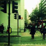
A defining quality of any city is movement. With an abundance of people, cars, bikes, trains, subways, developments, and construction projects comes an abundance of motion. What makes a city unique is its particular style or “flow,” as described by Michael Sorkin. [1] This manifests in its “movement hierarchy” – the delineation of deference for particular means of transportation. [1]

In New York City, Robert Moses designed infrastructure to prioritize the movement of vehicles. [2] Based on my experiences in Portland, particularly in discussing the busy roads around Congress Square Park with urban designer Caitlin Cameron, cars appear to be prioritized above pedestrians in some places. That being said, I have found Portland to be very walkable and have had little trouble crossing streets.

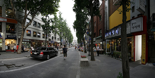
Commercial Street supports a lot of flow, both pedestrian and vehicular. Its proximity to the water gives it much potential, but the busyness and design of the road make it less appealing for pedestrians. The piers on the waterfront are a visual reminder of the city’s roots in lobster, fishing and trading. As the city gentrifies and develops, it is important to emphasize this history through smart adjustments in infrastructure.

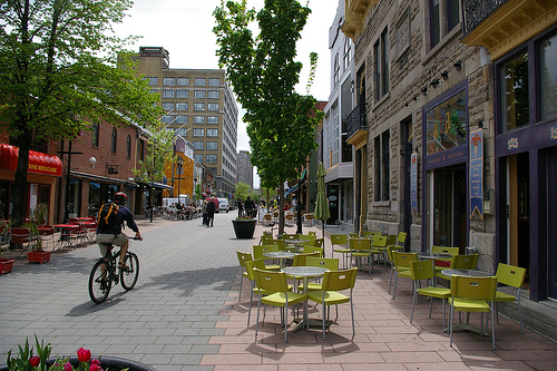
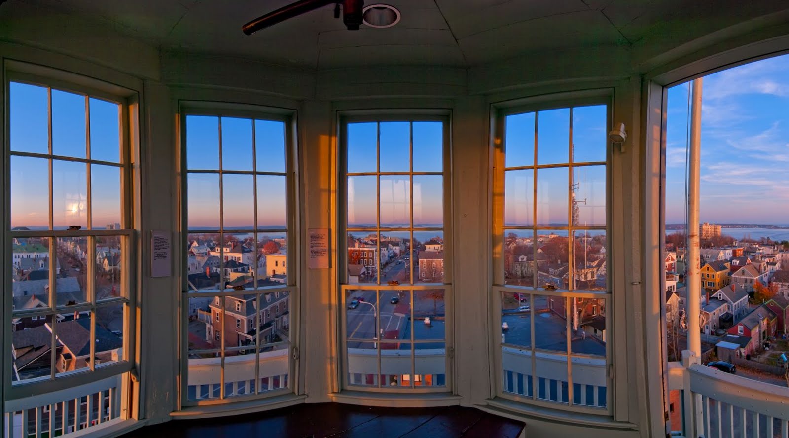
A grassy, well-landscaped walkway along the waterfront could serve these purposes. New York City’s Highline first comes to mind as an example of an engaging and exciting walkway, with benches, food carts, public art, beautiful views and a constant stream of pedestrian motion. Though this hypothetical Portland walkway would be much shorter in length and would not be elevated, the Highline might serve as inspiration.

14432
NYC Highline

In class, we discussed the idea of incorporating public history into Portland’s public space. Signs, plaques and sculptures throughout the walkway could include stories, facts and legends of Portland’s waterfront. Including public art in the walkway would harness the artistic community to increase its visual appeal, and as William Whyte taught us, inviting seating would be essential. [3] Food trucks/carts or small farmers markets would also work well in this space. Elevated lookout points would accentuate the beauty of the Maine coastline while giving a new perspective to the layout of the city itself.

[1] Sorkin, Michael. 2014 [1999]. “Traffic in Democracy.” In The People, Place and Space Reader, edited by Jen Jack Gieseking, et al, 411-415. New York: Routledge, 2014.

[2] Berman, Marshall. 1988. “In the Forest of Symbols: Some Notes on Modernism in New York.” In All That Is Solid Melts into Air: The Experience of Modernity, 287–348. New York: Penguin.

[3] Whyte, William. The Social Life of Small Urban Spaces. New York: Project for Public Spaces Inc, 2001.

Creativity Through the Use of Open-Source Networks

Infrastructure where information is used free to the public is most useful in smart cities. Open-source hardware is open-source because of “its deign process”[1]. When people cumulate ideas together there is an increase of product efficiency. The means that the contributors to the design of the item is “entangled in the social process of making or hacking property.”[2]This is influential to the productivity of the city and, more importantly, initiates creativity and room for improvement. Being able to connect and improve ideas in real times is a goal and useful tool smart cities need to adopt. This would help create more efficient traffic. Flow within a city “imposes its own idea of efficiency, always calibrated to keeping going, not stopping, overcoming impedance and resisting inertia.”[3]

To create infrastructure for the common good there needs to be a richer flow through the city. Sorkins describes it as non-stopping or in other words fluid. Part of the problem that Sorkins notices is the small spaces where humans interact in our economy. Simone describes the issue in an Urban African city by seeing the activities of “cooking, reciting, selling, loading and unloading, fighting, praying, relaxing, pounding, and buying happen side by side, on stages too cramped, too deteriorated, too clogged with waste, history, energy, and sweat to sustain all of them.”[4] He uses such words to visualize the amount of waste. Avoiding these spaces that promote social and openness creates an open creative one. The process of a scene where everyone is contributing to society allows more complexity toward ideas and social capital which is beneficial.

Portland needs infrastructure that promotes open source spaces where the ideas are evolving becoming more innovated and useful. The issue with this is that there needs to be a regulating committee to check if the design is being hurt or mishandled in a way. Portland could use a system that connects these individuals together toward a greater society and city.


[1] Jimenez

[2] Ibid

[3] Sorkins

[4]Simone

Separation as Increased Access: “Smarter” Flow in Traffic Infrastructure

Both in-class discussions and readings regarding infrastructure involve debate about the “right to infrastructure,” and most prominently is the constant tension between pedestrians and cars— which should be prioritized in urban infrastructure planning. In his essay, “Traffic in Democracy,” Sorkin talks about how the city “organizes its prejudices and privileges physically,” specifically exemplifying how New York physically prioritized motor vehicles in its closing down of 50th Street pedestrian crossings. [1] Many have questioned New York’s decision, stating that such measures does not create equal access to the City.

First and foremost, the “equal” in “equal access to the city” needs to be qualified. “Equal” should be within relatively similar contexts. Surely, a Manhattan resident has more access to Midtown than a Long Islander. At this point, one may argue that even within Manhattan, motorists and pedestrians do not receive equal access to the roads. The equality here deserves qualifying, too. “Equal access” should mean that motorists receive equal access to the motor lanes, and all pedestrians should receive equal access to the walking lanes. Cross-comparing motorists and pedestrians is meaningless, as I will argue in the next paragraph.

Before I discuss the hierarchy between motorists and non-motorists, I would like to highlight that these two groups are not mutually exclusive— a person decides which transportation method he will use based on his specific situation. For example, if I travelled from far away, or if I am in hurry to reach my destination, I may choose to drive. If I intend to get more exercise, or I simply am not in a hurry, I may choose to walk. The decision of being a motorist or not is more dependent on which gives the person more utility. Surely a person in a hurry should not be waiting for a person that is not.

So how to promote smarter infrastructure and city experience for all if the road is not meant to be divided equally between cars and pedestrians? My suggestion is to have dedicated passageways for each. Motorists travel from further distances and prioritize saving time, so a couple major roads and thruways can be dedicated for their usage, with big parking lots accessible near the thruways. At the same time, other roads should be converted to exclusive pedestrian usage. Separating different forms of traffic based on their different speeds and needs will improve the flow and efficiency of the city, while also minimizing congestion. Sorkin describes the “flow” in New York, and how that resulted in slower moving bodies deferring to faster ones. [1] However, if we separate them, no group would have to specifically defer to another. And this is definitely something Portland can implement with its current roads system.

[1] Michael Sorkin, “Traffic in Democracy,” in The People and Space Reader, ed. Jen Jack Gieseking, et al (New York: Routledge), 2014, 411-415.


Creating a People Friendly Street

Jiménez describes and defines what he believes to be the right to infrastructure. He claims that, “The infrastructure is not something that is ‘added’ to the social…but, rather, something that becomes reinscribed as a constitutive ‘right’—the right to define and redefine one’s infrastructural being.” [1] Whereas some aspects of a city are additional, such as aquariums, galleries, or museums, infrastructure is a key component to the structural existence of a city. It is a right, not only for the city, but also for the people.

Useful kinds of infrastructure include physical, such as highways, electric power; social, such as police and hospitals; and data, such as the underlying codes that run the city. Simone reinforced this idea of infrastructure by taking it to the next level, claiming that not only are the physical elements of a city essential to the infrastructure, but also the people living within the city can form their own infrastructure. [2]

In Sorkin’s essay, he describes an essential element of infrastructure is the flow, which is directly related to conflict avoidance. [3] This means, the flow of traffic and how efficiently things run. When I interviewed a man in Portland for the mental maps, he mentioned that Portland should import the Woonerf sidewalk and public space system, which would help the neighborhoods flow. It is a system based on the concept of shared space that encourages interaction between all forms of transportation (i.e. bikes, pedestrians, and motor vehicles). This includes the idea that the sidewalks are at the same level as the roads on which vehicles drive, and in fact, sidewalks and bike lanes are not even labeled separately. This allows for travelers to be conscious of their surroundings, which creates a more equal system of travel, along with a more people friendly environment.

Another idea that would help advance the infrastructure in a city would be putting the electrical systems and telephone lines underground. This is helpful in the case of a storm, so the power is less likely to go out, and it makes the streets safer, and more aesthetically pleasing. Though these are not necessarily the “smartest” ideas, they are the beginning to creating a more friendly and clean space for the people who live there.

4775157676_38b75188d7


[4][5] These pictures are examples of the Woonerf system.

Woonerf

1. Jiménez, Alberto Corsín. 2014. “The Right to Infrastructure: a Prototype for Open Source Urbanism.” Environment and Planning D: Society and Space 32 (2): 348.

2. Simone, AbdulMaliq. 2014 [2004]. “People as Infrastructure: Intersecting Fragments in Johannesburg.” In The People, Place and Space Reader, edited by Jen Jack Gieseking, et al, 241–46. New York: Routledge.

3. Sorkin, Michael. 2014 [1999]. “Traffic in Democracy.” In The People, Place and Space Reader, edited by Jen Jack Gieseking, et al, 411-415. New York: Routledge, 2014.

4. Woonerf. Digital image.  Web. 8 Oct. 2014. http://www.livingstreetsalliance.org/wp-content/uploads/2012/01/Woonerf.jpg

5. Insa-Dong Woonerf. Digital Image. Web. 8 Oct. 2014. https://c1.staticflickr.com/5/4117/4775157676_38b75188d7.jpg

Human Infrastructure to Fill Out Physical Infrastructure

“People as infrastructure” is a concept at the core of any healthy and thriving city. People are the most important part of the city—without them there is no culture, no community, no innovation, and reason for innovation to exist. There is no city without people. In all cities, people function as cultural infrastructure, and in some cities as even more.

In New York City (and around the world), people absolutely function as the infrastructure of city image. While the specific purpose of the infrastructure varies—be it image, black market, street art, punk rock— cities are filled with networks of people without whom a factor of the city’s life would crumple. Networks of people are the infrastructure of culture; in Johannesburg they are the infrastructure of life, as well.

In Johannesburg and other African urban centers, people function as infrastructure in a more day-to-day way. Without this form of infrastructure residents might not have electricity, food, clothing. [1] In smaller communities, “people as infrastructure” can function as the lifeblood of cultural expression and organization. New Brunswick, New Jersey is home to a thriving punk rock scene that operates through semi-legal underground punk shows in residential basements. The location of each show is kept secret except through connection to the New Brunswick network of punk-rockers.

The problem is that you can’t just make people into infrastructural systems. In Johannesburg the human infrastructure developed out of need. Short of dire need for infrastructure, some form of guidance or policy is necessary to create a system in which “people as infrastructure” can form. Essentially, physical infrastructure may designed so that there is room for “people as infrastructure” to fill it out and make it operate to fuller potential. Once it is decided who should “give ground,” [2] those on the ground have the potential to make the system run as well as possible.

One of the best ways to make infrastructure work well, and traffic flow smoothly, is good communication between the moving parts. In London there are three different kinds of crosswalks: the zebra crossing where pedestrians always have the right of way, a smaller designated crossing where motorists always have the right of way, and a crossing controlled by traffic lights where the right of way is allotted to each. These crossings are not only well marked, they are well-conceived. They each fulfill a different and often site specific need in the city.

This crossing system, which relies on the knowledge and judgment of people, is a form of promoting “people as infrastructure.” People who know exactly how to use the city make it function better and more efficiently. This knowledge is helped along through government supported “people as infrastructure,” too. On the pavement at every busy crossing is written “Look Left” or “Look Right,” to keep disorientated pedestrians from being hit by cars. This kind of guidance helps modern city traffic to move as quickly as possible on roads that in some cases were originally built for Roman foot soldiers.

Portland is such a small city that it seems ridiculous not to privilege pedestrians in most infrastructure. Part of this might just be putting in infrastructure to make the city more pedestrian friendly. This includes well-marked, free public parking in useful places, so that people get out of their cars to walk. It includes enough public seating to make walking a realistic and attractive means of transportation. It includes considerations of sidewalk width and street crossings that help pedestrians to be comfortable.

Whatever the changes, a clearly marked system would be pretty necessary for success since so many of the Portland’s summer pedestrians are tourists. Everyone can benefit from a little more clarity in public directions, though.


[1] Simone, AbdulMaliq. 2014 [2004]. “People as Infrastructure: Intersecting Fragments in Johannesburg.” In The People, Place and Space Reader, edited by Jen Jack Gieseking, et al, 245. New York: Routledge.

[2] Sorkin, Michael. 2014 [1999]. “Traffic in Democracy.” In The People, Place and Space Reader, edited by Jen Jack Gieseking, et al, 411. New York: Routledge, 2014.

[3] Britton, Ian. Pedestrian Crossing. Digital image. Freefoto.com. N.p., 2 June 2007. Web. 8 Oct. 2014.

[4] Screenshot from Google Maps, from post code W10 in London, UK. Coordinates for Google Maps [51.525564,-0.214748]

[5] London Crosswalk Countdowns. Digital image. Jocabola.com. N.p., n.d. Web. 8 Oct. 2014. <http://www.jocabola.com/archives/blog/london-crosswalk-countdowns/>.


Urban Flow

Sorkin evoked the fundamental idea in urban planning that there must be a balance achieved in between “consensus and accident” [1]. He emphasizes that “public spaces are preeminently places of circulation and exchange…the idea of which is under siege due to economic and social privatization, identity politics and communitarianism” [1]. There is one detail he mentions in “Traffic in Democracy” which seems to delineate a path that modern society is taking that I do not think many people actively take notice of: that “public space has become abstract due to decorporealization” [1]. Somehow, the presence of pedestrians and free wills exerted over New York City crosswalks characterizes the city as a place of normalized chaos. To give the hierarchy over to cars by eliminating the crosswalks on 50th Street, however, is to yield to those who embody the modern transportation mentality: that cars are a symbol, vessel and incubator for self-empowered spatial and temporal “liberation”. It seems that motion sickness has developed into an anxiety due to lack of motion, and that there is a generation of restless urban nomads being created. Their sense of place, stability and home is changing as more of their experiences are dissociated from the reality on the sidewalk. For this reason, pedestrians deserve to maintain their rights of way, and the drivers should have infrastructural renovations conducive to flow.


Pathway infrastructure must be planned to enhance the flow of movement and decongest the city’s traffic, but at the same time express the fact that the “potential for conflict is vital” [1] to urban democracy. I see the city as a great big experimental work in progress, exciting because it is where cultural evolution is so accelerated, where all individuals are the actors. The enabling of flow must be intersected with choice, because exciting paths are never straight. Flow is not just movement but also direction and change, and that requires us to occasionally pause. Streets require nodes to intercept the flow, to guide those who need to get somewhere and to create spaces for wanderers in search of new paths. Abdul Maliq Simone said that “intersections defer calcification” [2], more so referring to the sort of thriving chaos in the city than vehicular traffic. Because with traffic, the drivers have choice in their paths. He also implies that there is an exchange people should be willing to make: Endure traffic and preserve the dynamism of the city, or let the busy roads rise to the top of the movement hierarchy and carve the streets into deep canyons.

[1] Michael Sorkin, “Traffic in Democracy,” in The People and Space Reader, ed. Jen Jack Gieseking, et al (New York: Routledge), 2014, 411-415.

[2] Abdul Maliq Simone, “People as Infrastructure: Intersecting Fragments in Johannesburg,” in People and Space Reader, ed. Jen Jack Gieseking, et al (New York: Routledge), 2014 (2004), 241-246.

Concrete Jungles

“It is neither a right to infrastructure, nor an infrastructure made right. Rather, the right to infrastructure allows us to escape the human-nonhuman and epistemology-ontology dichotomies altogether by opening up the agential work of infrastructures as a source or possibilities in their own right.” (Jiminez, 343)

Infrastructure subtly dictates all aspects of individuals’ or vehicles’ movement within a city. Not only does infrastructure physically organize the city in a way that forces traffic to flow in a specific pattern, infrastructure has the capacity to completely command the way that people think about their own movement within a city. This idea of a city’s infrastructure defining the way that we live connects to the broader idea in Jiminez that we, as a city, have the right to produce infrastructure and that infrastructure has the right to produce us by altering the decisions we make.[1]

In fueling life within the city, the local electrical is potentially one of the most important parts of a City’s infrastructure as it invisibly connects everyone. In smart cities, the electrical grid, and ones open-access to the grid, create opportunities for residents to be engaged and interacting with its many powerful components. I think the type of infrastructure that would be most useful in a smart city would be an interactive, multi-dimensional electrical grid that uses not only typical sources of power like coal or gas, but also more green energy options like wind turbines, solar energy, or hydropower. In addition, I think it would be incredibly beneficial and efficient if homeowners had all-day access to information about the type and amount of energy their homes and navigation around the city uses from the central grid. By incorporating green into the smart city’s central grid, the city would reduce its harmful impacts by reducing carbon emissions into the atmosphere but also would potentially reduce its energy consumption if residents knew the ramifications of their immediate actions. Having green initiatives would also make transitioning from fossil fuels to other forms of renewable energy easier in the future.

In order for the green energy to have the largest effect on reducing a city’s energy consumption, there would need to be a very individualized and open approach to how data is transported back to the consumer. This open approach should not be a problem in smart cities – everyone is connected to technology and the grid at all times through mobile devices or mainstream computer systems, and therefore this concept of remotely controlling one’s consumption is definitely conceivable within a smart city. Residents would indeed be a part of the infrastructure (similar to ideas described in Simone) as they would be able to control the heating and electricity within their homes from a remote location and in addition, residents could use this Grid App on their phones or computers to request maintenance or help at any time. Some countries like England are already hopping on the remote controlled home heating bandwagon – http://www.britishgas.co.uk/products-and-services/hive-active-heating.html . This type of green innovations would benefit the common good most as they reduce our long-term impacts on the environment and force homeowners to be more conscientious of their (sometimes unnecessary) energy consumption.

Though I think that Portland would seriously benefit from having this hi-tech and efficient energy grid system, I do not think that it would be the most beneficial thing for the city as a whole because Portland residents may not yet have access to smart technology in order to fully utilize the system (because Portland is not yet a fully smart city). I think that the most beneficial infrastructure change for Portland would be taller buildings within the center of the city. I really liked the ideas we discussed about Times Square in New York City from Sorkin. According to Sorkin and our class discussion, the height of architecture can seriously change the way that people think about and navigate a city.[2] If Portland added some taller buildings, it would make the city seem larger, and therefore easier to get lost or be fully immersed in.

In addition to taller buildings, having one street that was closed down (or closed down on one night each week like they do in Hamilton, Bermuda every wednesday night http://www.bermuda.com/media/5360795/choc-harbnitefullpgadrg2014.pdf ) would likely have an exciting effect on the nightlife and the use of public space within Portland. This type of area would be great for tourists and local businesses and it would probably not have that large of an effect on traffic and flow patterns because Portland is a relatively small city. Even if it did affect the flow of the city, as described in Sorkin, cities are reciprocal, open and flexible ensembles and can continuously remold themselves through repeated social interactions.[3] This all being said, if the city were to commit to this much open space, they would have to stick to their current ground hierarchy of pedestrians, bikes, busses, then cars as opposed to the opposite experienced in New York City.[2]

[1] Jiminez, Alberto Corsin. “The Right to Infrastructure: A Prototype for Open Source Urbanism.” Environmental Planning D: Society and Space 32 (2014): 342-62.

[2] Sorkin, Michael. “Introduction: Traffic in Democracy “. The People, Place, and Space Reader (1999): 411-15.

[3] Simone, AbdouMaliq. “People as Infrastructure: Intersecting Fragments in Johannesburg.” The People, Place, and Space Reader (2004): 240-46.

Residential and Tourist Infrastructure

Portland is rapidly expanding and urbanizing, growing both in its residential and tourist area. In both respects, Portland is still developing and is not on as large of a scale as New York City, so it neither possesses nor requires such large scale infrastructure. However, infrastructural improvements in both a literal and open source sense could satisfy the city’s growing physical needs and enhance its efficiency and technological capabilities.

Cities constantly seek to function more efficiently and “modern city planning is structured around an armature of such conflict avoidance.” [1] While Portland does not attract a large enough volume of traffic to recreate New York traffic patterns, efficiency is still central to the city’s plan for commuters and visitors in and out of the city. Many of Portland’s residential areas are set up in the Jeffersonian grid (see the West End and Munjoy Hill https://www.google.com/maps/place/Portland,+ME/@43.6582817,-70.2627314,3397m/data=!3m1!1e3!4m2!3m1!1s0x4cb29c72aab0ee2d:0x7e9db6b53372fa29“) and from my experience traffic flows well through the busier downtown areas. One recommendation for Portland would be more paths for walkers and cyclists, either designated bike lanes (which the city seems to lack from a quick Google Earth scan) or elevated pathways. Such pedestrian infrastructure would satisfy the hierarchy of “elevated highways, pedestrian skyways…and other movement technologies…for the sake of efficient flow,” [2] which Sorkin argues is necessary to promote urban efficiency and cohesion.

Open source infrastructure could manifest itself in resident-managed community gardens, and new public spaces crafted by citizens themselves would promote residents’ own needs. As Jiménez writes, “such interventions in the urban fabric are transforming, and even directly challenging, the public qualities of urban space.” [3] As Portland continues to be affected by urbanization, it figures that the city’s new populations would want to have a say in the development of their urban space, much like the residents of El Campo experiment.

In terms of its tourist infrastructure, Portland has failed to capitalize on its prime location as a waterfront city. With a relatively flat skyline and with few non-working, “touristy” piers, there is not really any infrastructure through which tourists can take advantage of Portland’s spectacular location and vistas. Adding some lookout towers would provide tourists with such vantage points and make Portland’s skyline more interesting and memorable, something that urban planners and residents have been looking for.

3x5 inch Sunset view from Inside Portland Observatory
Sunset from the Portland Observatory located in Munjoy Hill. [4]

In addition to lookouts, other infrastructure such as bridges or boat docks would enable Portland tourists to explore Portland and its neighboring environments. Between downtown Portland and South Portland is a half-mile spit of water which could be spanned with a bridge catered for walkers and cyclists. Tourists could take this path from downtown Portland and, in a matter of minutes, arrive at Bug Light Park or nearby Simonton Cove, a spectacular beach on the Southern Maine Community College campus that I visited during a geology lab last week.

Bug LIght Park
Bug Light Park located on the tip of South Portland. [5]
These proposed infrastructures could incorporate smart technology in numerous ways. First of all, smartphone apps with maps of Portland and walking or bike trails could help tourists navigate through the city. Sensor activated water and light displays along these paths would enhance the Portland aesthetic while conserving energy, only activating when someone is within a certain radius. Finally, heated sidewalks, bike lanes, and walkways would make these paths usable all year long. Although installing such technology would be expensive, it would require less maintenance during the winter months and eliminating the need for salt would help protect the ocean environments.


[1] Sorkin, Michael. 2014 [1999]. “Traffic in Democracy.” In The People, Place and Space Reader, edited by Jen Jack Gieseking, et al, 411. New York: Routledge, 2014.

[2] Sorkin, Michael. 2014 [1999]. “Traffic in Democracy.” In The People, Place and Space Reader, edited by Jen Jack Gieseking, et al, 411. New York: Routledge, 2014.

[3] Jiménez, Alberto Corsín. 2014. “The Right to Infrastructure: a Prototype for Open Source Urbanism.” Environment and Planning D: Society and Space 32 (2): 342.

[4] Farr-Weinfield, Cynthia. “Greater Portland Convention and Visitors Bureau News.” Blogspot. Last modified March 7, 2010. http://cindysphotoquest.blogspot.com/2010/03/greater-portland-convention-and.html.

[5] Templeton, Cory. “Out Here in the Fields.” Portland Daily Photo. Last modified June 27, 2012. http://www.portlanddailyphoto.com/2012_06_01_archive.html.

The Human Character of Infrastructure

Infrastructure constantly needs to be updated and kept up with the current standards of a city, however, more importantly a smart city needs to worry about the human character aspect of infrastructure. As Sorkin writes, “the human character of cities begins with face to face interaction”[1]. In other words, different types of human interactions shape the personality and style of a city. Additionally, through coming face to face with so many people, a city is creating a sense of social responsibility and an environment for its inhabitants to live in.

Open source technology aids in the idea of creating a social infrastructure and making it much more accessible, friendly, and representative, due its readily availability to the general public. The public receives real time and up to date services that any one can obtain or edit, thus aiding in human interacting, which is also displayed in the Jiménez reading [2]. An added plus is way in which the city will be represented, due to the fact  that a little bit of everyone that contributed will be a part of the outcome, and not just the input or vision of a minority of people.

Similarly to Sorkin and Jiménez, Simone expresses the same ideals of infrastructure by taking a closer look into the structure of Johannesburg. He shows us that people can also serve as infrastructure. When infrastructure in not in place, people make do with their surroundings [3]. With this comes a strong sense of community, and ownership of a city. Simone shows us that it is important to not put too much stress on infrastructure because then cities will become too constricted. This is very important because a strong quality that a smart city needs to maintain is innovation and creativity.

For Portland, Jiménez’s idea of the “right to infrastructure” goes well with the idea of the common good [2]. Every inhabitant of the city has the basic right to claim ownership . The infrastructure should be set up in a way that it gives everyone the opportunity to freely shape his or her life around it. I think that Portland would greatly benefit from open-source data or crowd-sourcing. It allows for open communication and huge amounts of innovation. Crowd-sourcing could go towards some form of more efficient and sustainable public transportation system.

Works cited

[1] Michael Sorkin, “Traffic in Democracy,” in The People and Space Reader, ed. Jen Jack Gieseking, et al (New York: Routledge), 2014, 411-415.

[2] Alberto Cosin Jiménez, “The Right to Infrastructure: a Prototype for Open Source Urbanism,” Environment and Planning D: Society and Space 32 (2): 342-62, 2014.

[3] Abdul Maliq Simone, “People as Infrastructure: Intersecting Fragments in Johannesburg,” in People and Space Reader, ed. Jen Jack Gieseking, et al (New York: Routledge), 2014 (2004), 241-246.


People-Friendly Roads in the Old Port

mario bros 001


This is the image that comes to mind anytime I think about infrastructure. Unfortunately (or luckily, depending on your perspective of the subject) goombas and koopas aren’t quite the infrastructural issues that smart cities have to deal with. AbdouMaliq Simone would even suggest that the infrastructure of modern cities isn’t necessarily just the the streets, the pipes below them, and the electric fiber and fiber optic cables above them both: it can be the people of the city too. (241) Portland, Maine is a fairly homogenous area: even with the East African migration to the area, the city still remains largely white with a fairly large middle class—hardly the class dichotomy that exists in Johannesburg. However, what’s important to realize is that the people share a common reliance on cars to travel to and fro, regardless of distance. What’s also important to realize is that Portland is hardly organized in a way that plays to the benefit of this reliance.

In terms of this infrastructure, I believe that Portland could benefit heavily from a pedestrian/biker-friendly development project. Michael Sorkin suggests that cities (neighborhoods specifically) should be constructed “in a way that binds them to the [human] body and what it can do.” (415) In this case, I interpret this in a way that makes the body a positive attribute in navigating the city, freeing us from the constriction of vehicular movement through naturally human spaces. Many of the streets, especially in Old Port, are cramped, narrow, and one-way, making passage with a vehicle difficult in the first place. In a different direction, Exchange and Franklin Streets represent two of the city’s most obvious boundaries (aside from I-295) and are more or less un-crossable by all but the bravest walkers and bikers. Ironically enough, Mainers would obey crossing the street if there were stoplights and walk signals, but less than a quarter of the crosswalks are supported by these traffic signals. A step from which Portland would benefit would be to close down many of the more narrow streets within the city to pedestrian and bike traffic (much like Bowdoin’s campus) and narrow the Franklin and Exchange street arteries to two-lane roads. A step like this would likely not increase traffic and would even encourage Old Port users to walk the city from the periphery rather than drive to the center and branch outward (which is safer and more practical, for all parties involved.) Bike lanes would also encourage a go-green alternative to driving to work, which would declutter traffic routes, benefit the environment, and encourage a healthful form of exercise. Imagine that—city planning as a solution to America’s “obesity epidemic!” What’s important for Portland to realize is that it is a small and navigable city, and increased vehicle traffic will actually have the opposite effect of decreased traffic: it would discourage users from visiting the city on the bounds of having to navigate the streets and compete with bikes and walkers on the quaintly congested streets of the old city. Even with the cold Maine climate, Portland’s size makes it tolerably navigable by foot and bike even during the winter. If Mainers have any doubt about that, here’s a picture of Copenhagen in January:

copenhagen-bike-snow-for-web

Doable? I think so.

Also, even though there is an aspect of Portland that embraces its cobblestone streets, we should recognize that there are smart city options to paving our streets and taking better advantage of our impermeable surfaces. This video details one such smart-city solution:

Its easy to see how such a technology could benefit a city like Portland. Massive solar panel arrays equal big savings in energy expenditure in the long run, and since the buildings in Portland are pretty short, the amount of time that our streets and parking lots would be exposed to sunlight is much higher than in most any other city. The passive snow removal technology would be a huge bonus, saving the city thousands and thousands of dollars in snow removal using clunky plows, followed by massive expenditures in repaving every few springs as a result of the plow’s damaging effect on the roads. No need to salt the streets either, which would be an added bonus to the environment! Portland is a small city, so implementing a technology could be done both cost-effectively and fairly quickly—within a few years if not months, given the funding’s in place.

References:

  • Simone, AbdouMaliq. 2004. “People as Infrastructure: Intersecting Fragments in Johannesburg” from People, place, and space reader. [Gieseking et al] Routledge, New York
  • Sorkin, Michael. 1999. “Traffic In Democracy” from People, place, and space reader. [Gieseking et al] Routledge, New York
  • Images: criticalmass.hu and laestanteriadecho.blogspot.com
  • YouTube