
[gview file=”https://courses.bowdoin.edu/digital-computational-studies-2430-fall-2014/wp-content/uploads/sites/52/2014/12/First-Half-of-DIOTC-Final-Paper-Race-and-Crime.pdf”][gview file=”https://courses.bowdoin.edu/digital-computational-studies-2430-fall-2014/wp-content/uploads/sites/52/2014/12/Second-Half-of-DIOTC-Final-Paper-Race-and-Crime.pdf”]
All posts by pnauffts
Mapping Patterns in Crime
Anger in response to the lack of indictment of two white police officers responsible for killing two unarmed black men should not be over-particularized. Without diminishing their lives, these men are symptomatic of larger trends in this country: minority populations are severely overrepresented in our country’s prisons. It is our obligation to society to examine why this is, to look at unpleasant truths, and ultimately, to begin to reconcile our past with the future.
I propose to map and critically analyze crime statistics in Portland, Maine. With any luck, thanks to the Freedom of Information Act, I will be able to sort and geocode a dataset of all the crimes committed in the past year, along with detailed breakdowns of the type of crime and the identity of the accused. I will map this against the background of recent Portland census data on racial and economic makeup of areas where crimes occur and, if possible, the areas from which the accused criminals hail.*
The empirical will be accompanied by a theoretical consideration of factors that effect crime. Discussions of how, in the days following Michael Brown’s killing, authorities tried to slander his character offer a jumping-off point. To what extent must we pin crimes on the perpetrators as competent moral agents? How much (and how) should we weigh socioeconomic background in the equation? Ultimately, though, the questions that matter most to the everyday lives of Portlanders involve how we can better police the streets, and, further, how to redress the root causes of inequity, even injustice. Specifically, I will engage with the work of Dolores Hayden to dissect the complex and subtle ways in which power is exerted in space in a formative manner. I would like to read Sue Ruddick’s “Constructing Differences in Public Spaces: Race, Class and Gender as Interlocking Systems.”
The model for my mapping will be the Million Dollar Block Project produced by Columbia’s Spatial Information Design Lab (SIDL). The project’s fundamental thesis shifts focus on crime from the location of the events. Such focus leads to heavier policing of “hotspots” but this framework for crime prevention has not done enough to halt crime and has instead resulted in an astronomical incarceration rate. Instead, SIDL seeks to map residencies of criminals in an effort to reveal how we as a society have failed to provide the proper infrastructure to impoverished communities—infrastructure that keeps them out of prisons.[1]
An analysis of crime, race, and socioeconomics in this country can never be free from controversy—we have too long and too ugly a history with the words to produce anything else. Critical mapping and data visualization offers a sophisticated way to consider such data, one that is both digestible and informative. Policymakers and Portland residents alike would benefit from better data about crime, and hopefully it could inspire difficult discussions about the common good.
*Because of the sensitive nature of the data and the potential home location information, I am not certain that this data should be made publically available (at least not in full).
[1] Cadora, Eric and Kurgan, Laura, “Million Dollar Block Project,” Spatial Information Design Lab, Columbia University. http://www.spatialinformationdesignlab.org/sites/default/files/publication_pdfs/PDF_04.pdf
Hilltop Coffe Cafe Ethnography and Maps


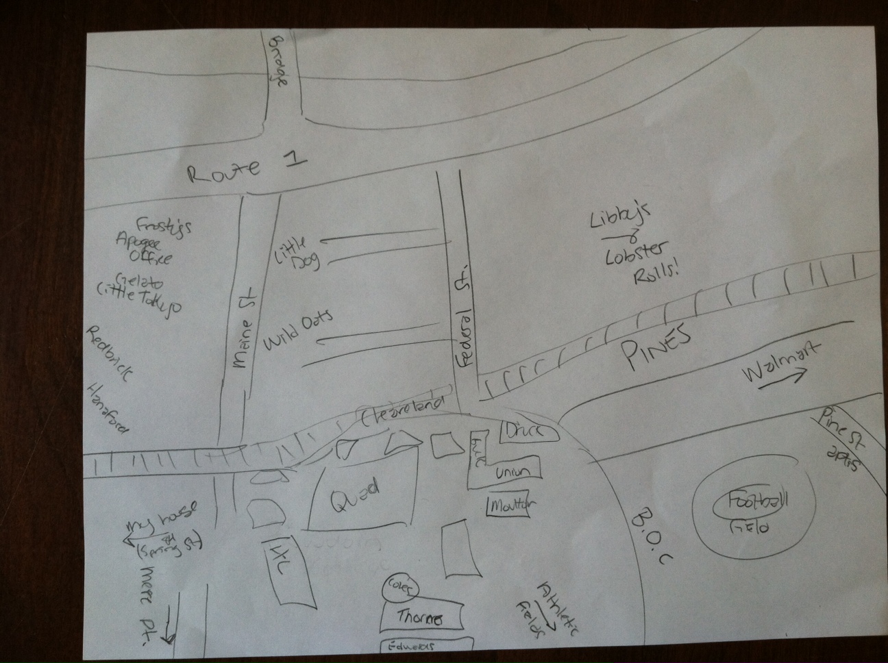
Two things are particularly worth note: that the coffee shop was, on the whole, pretty busy all morning, and two, that it was busy with a rather specific population. I don’t know the demographics of Portland, but if this coffee shop had been taken as representative, it would be a city of under 30 year olds, all white and relatively well off. Perhaps this is the kind of crowd a coffee shop draws. But it is a curious thing to witness anyway. Where is everyone else? I think, to the extent that I can extrapolate, my mental maps confirmed this trend. Though they varied in age and gender, the mappers most frequently identified local eating establishments and upscale shops. Few people identified landmarks or museums or libraries—public or free spaces. It confirms my interest in a more inviting and economically mixed Portland.
10:00—Sitting facing the window, I notice that the streets are super busy. Lots of young, hip looking people in flannels and men with beards.
10:10—It’s pretty full in here, roughly 25 people. A few empty seats. People are encouraged to sit together, as there are lots of twotops.
10:20—Emptier now. Still, I’m noticing that it is very loud! The espresso machine or whatever is constantly buzzing, milk is being frothed. Nice indie rock drones. Conversation is quiet and minimal, a couple is sitting doing the crossword in one seat. Cute.
10:30—(I drew a map of the coffee shop, showing a variety of smaller seating around the perimeter—which, by the way, was a pretty small rectangle, roughly 20 by 25 feet—and a big long table for 8 or so in the middle of the place.)
10:40—Not very busy now. 2 conversations or so, I can hear the music pretty clearly. A man with a cowboy hat enters. 10 people total inside. 5 people at least are 25 or under, one is maybe over 60, all are white.
10:50—The guy sitting across from me is youngish, with a huge beard and tattoo sleeve, skinny. Another older man, maybe 60 walks in, but he is well in the minority.
11:00—A bus drove by with a big U.S. Cellular ad—is it a public bus? Someone enters with a stroller, maybe the first one I’ve seen? Also, just a note on the space, it’s pretty dimly lit, and as said before, pretty minimalist as a space. Small, cozy, not very much in the way of decoration except for some pumpkins. Big windows on the two street-facing sides. They don’t have much of a menu it seems.
11:10—Down to 6 people. 3 were here when I arrived. A biker has entered. I’ve seen lots of bikers ride by. Cars at this point seem pretty infrequent for a main thoroughfare (Congress). So are people on the street.
11:20—Ok, it’s gotten busier again. An elderly lady with a pushcart and a cool headscarf has struck up a seemingly spontaneous conversation with a younger woman.
11:30—Worth describing the general appearance of people—if I can take that liberty. First off, just about everybody is rather put together (cafes are great places to show off). Lots of boots, a few of which are bean boots. Still lots of facial hair amongst males. Patagonia and Northface abound.
11:40—Hats, lots of baseball caps! They are never fitted caps—that’s not how Mainers do it, it seems. They are faded, roughed up, blues and beiges. As if to say, “I don’t care too much…” It is very in line with the yuppie look.
11:50—Two guys walk in who seem to be in construction. They have on dark blue jeans with paint and grass and dirt stains. They have matching sweatshirts with a company’s name on it. They are the first people who seem to be working, and manual labor at that.
12:00—Lots of people are entering and taking coffee or food to go. People who sit down are here for the long haul. One is reading Frankenstein, another is reading The Odyssey. One does sudokus. Someone has the Wall Street Journal out—what?? 5 men, 6 women.
12:10—There is now one Asian person here—and he happens to be a former Bowdoin student.
12:20—I notice the bus again, and see that it is indeed a municipal bus. I can’t see if it’s crowded or not, but I would guess that it isn’t…
12:30—A trolley cruises by. Has to be tourists. The café is still pretty quiet. People on their Macs are still chugging away.
Transect Walk of Munjoy Hill and East End
My transect walk brought to light a handful of things I couldn’t have realized through my ethnography or maps. Most notably, seeing the world surrounding Congress Street was interesting. It is very clearly in the process of changing—old structures stand next to beautiful new ones, buildings under construction abound, and parking lots dot the streets. It seems an important time for the neighborhood. Though Portland is close to housing capacity, it will remain in high demand, and I think there is a real need and opportunity to provide affordable housing options or mixed housing in prime neighborhoods. As my walk focused on architecture, it’ll be interesting to see what it says about socioeconomics. I have lots of pictures I will want to sift through.
8:00—I start by exiting a car at the corner of Congress and Washington Ave. I proceed up the hill and, not having had breakfast, stop into Katie Made Bakery. Roughly 183 Congress Street. I am focusing on the architecture of buildings in the area, how it changes and (later) what it means. For now, it has a pretty coherent vibe: mostly wooden structures, tall and boxy, with nice details over the entranceways. Nice colors as well.
8:30—Took some picture outside of 171 Congress Street to highlight the wooden buildings and their brick bases. They are also generally pretty interesting colors, an eclectic mix for sure.
8:35—On the corner of Cumberland and Sheridan, I have turned off of Congress to explore the depth of Munjoy Hill or East End. I’m looking at 66 Cumberland Ave., one of the more interesting houses I’ve seen. It is clearly multi-family. It has a big porch, which is unusual. It is a bit rundown, it seems. Notably, it is next to a beautiful, brand new house made of gorgeous painted wood and slick metal.
8:40—Still on Cumberland, noticing lots of parking lots. And the buildings tend to have a decent amount of space between them too. It is airy, un-oppressive.
8:45—Some sort of repairs going on in the building next to 49 Cumberland.
8:50—46 Cumberland, standing opposite a not-too-attractive 49 Cumberland, is an amazing new house. Multi-fam, I can tell. Beautiful wood, balconies. I wonder what it costs!
9:00—I’ve turned back onto Congress, and am faced with “118 on Munjoy Hill” a new luxury development. This is very curious. It is much bigger than the surrounding apartments, though attempting a similar style. I have lots of pictures.
9:10—Having passed my coffee shop, I’m standing across from The Front Room, a pretty fancy restaurant. I’m thinking to myself that Congress Streeet up here seems pretty devoid of nice restaurants, and is surprisingly residential overall. Should I be surprised? Pretty building.
9:20—I turn down Emerson Street, and stand looking at The Emerson School, a big brick building. This is the only school I’ve seen, and it looks nice. Is it private or public? Across the street is a beautiful orange house (pics) with a yard, one of the first I’ve seen. At this point, I’m past the peak of the hill, and I wonder if they have water views yet.
9:35—Got a mental map, excuse the pause. I’m in front of the Eastern Promenade Apartments, which don’t look particularly fancy. They remind me of Brunswick Apartments. Brick façade. Squat. 30 Turner Street.
9:43—On the corner of Morning and Turner streets. I’m looking north, across the street, at a big empty parking lot. How long will it be there? Who is it serving? It’s private, but the houses next to it don’t seem to require that much parking. It seems like prime real estate.
9:50—I’ve reached the end of Turner Street, at the intersection with Eastern Promenade. There is a baseball field across from me. And a playground. Tons of kids around, though not for an organized sport. This obviously must add huge appeal to the neighborhood.
10:00—Walking along the Eastern Promenade ogling the massive houses. I stay on the far side of the street—somehow, being too close seems like trespassing. They certainly have more character than the rest of the neighborhood (if not gaudiness). Overheard: “The product should jump off the page, and your product could be the rental [unit].” (Two middle-aged women, one with a dog.)
10:10—At the corner of the Eastern Promenade and Congress Streets, in front of the monument, I notice many many private tour busses driving by, and stopping here, and then continuing.
10:20—It seems to me that even here on the Prom, many houses might be multi-family. I’m not sure though. It seems a phenomenon sort of unique to Portland, or at least not something I’ve seen, to have so many multi-unit building that look as if they are for one family. They are houses, not apartment buildings.
10:30—Although only tangentially related, down by the water there are tons of families, all young, with strollers and baseball mits etcetera. And many dogs. It seems very safe, very friendly.
An Emphasis on Physical Interaction
Sorkin briefly but effectively makes a rather scary point in his piece, Traffic in Democracy: “the fundamental epistemology of the city—the way it constructs its meanings—is being transformed as physical presence ceases to be the privileged means of participation and enjoyment of urban life.”[1] Perhaps the fear is unwarranted, a byproduct of nostalgia that he suggests we try to avoid. Yet I believe strongly in his later statement that “the only training for living is living,”[2] and so unless we are willing to consider a new type of non- or less physical existence, fear seems at least a reasonable response. Call me a Luddite, but I hope to see physical space remain the dominant space of interaction as long as possible.
The Jiménez piece seems to put open-source technology to great use in the service of a more representative, accessible city. It is democratic to the core. Moreover, it allows for constant revision and updating.[3] It is a check on overzealous or power-hungry individuals (historically, figures like Robert Moses). And, to an important extent, it is cool; it attracts cool ideas, and leaves this impression on the final product, which makes them more appealing to use.
Finally, the Simone piece provides important insight of its own, which we came across to an extent in the readings on public space: the notion that people, ultimately, will make do with what they have. In the absence of certain infrastructure, we adapt. There is almost more risk on creating a too-rigid infrastructure, because it cannot be undone, while amorphous or incomplete infrastructure invites creativity and adaptation. At the most basic level, in Johannesburg, people serve as infrastructure.[4] This form of infrastructure, too, comes with strong and meaningful claims to identity in a way that might only be implicit in other spaces.
In regards to Portland, I’d like to see what would happen streets around Monument Square were closed off, and seating was added. I’d expect them to be fully occupied on nice days—of which there are not as many as we might like. Better public transportation seems a must, too—I don’t know anyone who has ever used it to get around the city. I would rather walk than figure out the maze of busses.
[1] Sorkin, Michael. 2014 [1999]. “Traffic in Democracy.” In The People, Place and Space Reader, edited by Jen Jack Gieseking, et al, 413. New York: Routledge, 2014.
[2] Ibid., 413.
[3] Jiménez, Alberto Corsín. 2014. “The Right to Infrastructure: a Prototype for Open Source Urbanism.” Environment and Planning D: Society and Space 32 (2): 343.
[4] Simone, AbdulMaliq. 2014 [2004]. “People as Infrastructure: Intersecting Fragments in Johannesburg.” In The People, Place and Space Reader, edited by Jen Jack Gieseking, et al, 241. New York: Routledge.
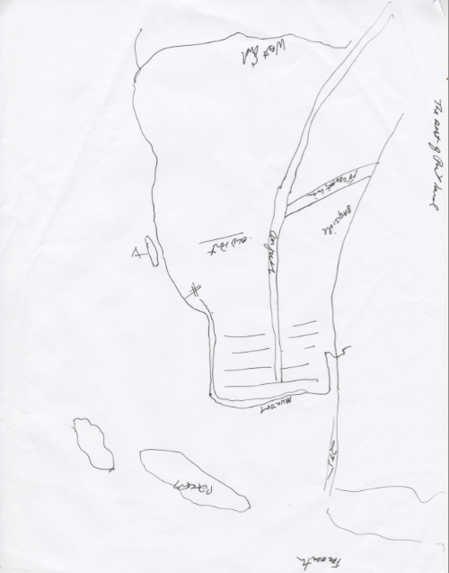
Brunswick Mental Map: Erin Leddy, 2015
Blog Post #3: Public Spaces against the Smart City
It seems that the proper function of a public space seems to function contrary to (or at least in tension with) the function of a smart city—or at least the smart city as proposed by the likes of IBM, Cisco, etcetera. Setha Low, for her part, praises those public spaces “where all people are embraced and tolerated,” places we go to “heal and reconcile our hopes and dreams.”[1] The smart city, however, identifies with efficiency, control, time-saving. These words are much more the words (and ideas) of capitalism and government authority than democratic forums a la the acropolis—they do not permit much in the way of deviation from intended purpose.
This is not to say that public space cannot coexist with the smart city; on the contrary, it suggests that public space is all the more necessary in modern urban society as a place of repose and reflection from the city (and in particular, perhaps, the smart city). And as a space for the promotion of the common good, it seems all the more crucial. Low notes that the places people created meaning in in the wake of 9/11 were the “more spontaneous, less-regulated spaces” such as Union Square.[2] Don Mitchell echoes this point, noting that public space rarely meets the demands of people “under conditions of its own choosing.”[3] The common good should not be a notion determined or framed by elites, regardless of their agendas. Thus the public space that serves the common good should be general, broad, and accessible to all.
To this end, I wonder how public wifi creates, as Low might call it, “a design vocabulary that appeals mainly to the upper-middle class.”[4] It is free, open to all, egalitarian in theory. But it means you must have a certain technology (one that is not even close to free) to take advantage of it. It becomes a status symbol, or simply narrows how the space is conceivably used.
Both Low and Mitchell complicate the idea of planning for a public space and thus defining what sort of common good it will serve. In a truly democratic spirit, it seems that the common good for a public space requires an amorphous quality, a lack of definition or imageability. This ensures it’s utility can be claimed by all—and especially by those who seek public space in lieu of private property.[5]
One potential idea for public space design in Portland could center around movement, and in particular walking. A narrow and long park, like Riverside in New York, promotes walking and, if not social interaction, at least awareness of others.
[1] Low, Setha M. 2002. “Spaces of Reflection, Recovery, and Resistance: Reimagining the Postindustrial Plaza.” In After the World Trade Center: Rethinking New York City, edited by Michael Sorkin and Sharon Zukin, 164. New York: Routledge.
[2] Ibid., 164.
[3] Mitchell, Don. 2014 [2003]. “To Go Again to Hyde Park: Public Space, Rights, and Social Justice.” In The People, Place and Space Reader, edited by Jen Jack Gieseking, et al, 195. New York: Routledge, 2014.
[4] Low, 164.
[5] Mitchell, 193.
5 Recommendations for a Smarter Portland—Housing (Peter)
- Zone more space for affordable housing, and build more affordable housing (not luxury condos).
- Optimize energy efficiency in new housing, thus saving money in the long run.
- Urban farming/ community garden initiatives.
- Guarantees that “smart city” technologies be deployed equitably across socioeconomic lines.
- Smarter coordination of public transit.
In discussing our various interests regarding housing, one aspect stood out as important to all of us: the problem homelessness in Portland. We were all struck by the rapid transition from commercial downtown Portland to Prebble Street and significant poverty. This has framed my attempt to conceive of recommendations for a better Portland: how can smart technology be used to help the worst-off?
As Angelidou so succinctly points out, “No specific advantages of hard infrastructure-oriented strategies are mentioned in the smart city literature.”[i] Furthermore, they do little to mitigate, if not actively promote, “Spatial polarization and gentrification, as technology take-up is not evenly spread throughout urban areas, with splintering effects on housing, consumption, lifestyle, leisure, etc.”[ii] This strikes me as a major problem, equally important as Greenfield’s wide-ranging critique of smart cities. Who gets smart technology, and who is positioned to reap its rewards? Greenfield mocks the neutrality of smart city public policy, and rightly so.[iii]
That said, while the first recommendation may not be “smart,” it seems imperative to a better Portland. In the light of the second recommendation, too, I would argue that new affordable housing projects could serve as prime testing grounds for smart efficiency strategies.
With regards to the third recommendation, I see it as located within a goal of integration of different socioeconomic groups in the city space. Housing will likely lead to stratification, and urban farming seems a good way to counter the tendency to cordon oneself off from “others”. This relates to the last point, which might seem out of place in the housing section. But as new housing would likely be built in less dense areas, it would be important to make sure public transportation reflected the needs of those who use it most, those with less money. Perhaps a rethinking of routes would be/ is already necessary.
[i] Angelidou, Margarita. 2014. “Smart City Policies: A Spatial Approach.” Cities, S6.
[ii] Ibid., S6.
[iii] Greenfield, Adam. 2013. Against the Smart City. 1.3 edition, page 37.
Gentrification, Security, and the Smart City
Peter Nauffts
I’m drawn, for mostly personal reasons, to the housing research group. My childhood (and still current) home is a rather small, rent-stabilized apartment in New York City (on the Upper West Side). Who lives in a neighborhood—and who can afford to live in a neighborhood—seems as clear a way to elucidate socioeconomic patterns of exclusion and inclusion as any. Housing prices dictate so many of our expectations for a neighborhood, from quality of education to safety, as well as the kinds of public spaces and infrastructure that the area provides. This is something I perhaps took for granted as a child growing up in New York.
I am particularly interested in the dimension of time as it relates to housing. How fast is a neighborhood gentrifying can be seen in many places, but housing seems as good as any a barometer. I have watched my neighborhood change rather dramatically over my 21 years of existence. Broadway is now mostly an arbitrary (and excessive) collection of banks, Verizon stores, Starbucks’, and banks. Is this simply the natural life (or decay) of a city—the mark of progress? Is stasis an option?
I take from the Dolores Hayden the interesting if brief discussion of Henri Lefebvre’s notion of economic production and social reproduction and space.[1] There is always a powerful nostalgia, or so it seems, in my parents voices among many others when they talk about the way the neighborhood used to be. Yet Lefebvre makes me wonder if in fact we have in all these spaces what we deserve: banks for wealthy people to conveniently withdraw and spend money, Starbucks’ for the type of service or more abstract labor that the denizens of this neighborhood engage in.
As far as smart cities go, I have to admit that I have never considered smart technology’s applicability to housing. I admit, too, I don’t own an iPhone—but still, I think it would be fascinating to consider smart technology in relation to this problem. Perhaps its applicability is not so well suited to an app, as a public space project might be. It does seem to be well-suited to mapping, however. I would be fascinated to watch, over time, the sort of tidal rise in housing prices as it consumes a city, spreading outwards slowly but surely. And less directly related, I am sure there would be a strong correlation between housing price and the demand for more high-tech security—Rio style—that Townsend speaks of.[2]
[1] Hayden, Dolores. 1997. “Urban Landscape History: The Sense of Place and Politics of Space.” In The Power of Place: Urban Landscapes as Public History, 18-19. Cambridge, MA: The MIT Press.
[2] Smart Cities: Big Data, Civic Hackers, and the Quest for a New Utopia [Anthony Townsend]. 2013. http://www.youtube.com/watch?v=z1evCV6_e8Q&feature=youtube_gdata_player