
Integrating Sustainable Features with Public Spaces
[gview file=”https://courses.bowdoin.edu/digital-computational-studies-2430-fall-2014/wp-content/uploads/sites/52/2014/12/Paper-Proposal-copy.docx”]
Emma Chow Final Paper: Recommendations for Creating a Recreation Hub in India Street Neighborhood
Emma Chow
Professor Gieseking
The Digital Image of the City
12/17/14
Recommendations for Creating a Recreation Hub at the Foot of India Street, Portland, Maine
Research Question
Once a bustling commercial hub of industry, Portland’s historic India Street Neighborhood has lost its neighborhood vitality and is now in need of revitalization. The India Street Sustainable Neighborhood Plan, published September 2014, is comprised of five goals, six vision statements, thirteen development principles, and twelve critical actions.[1] This paper focuses on Critical Action 11 – Create a Recreation Hub at the Foot of India Street, by giving recommendations for developing the Recreation Hub to best align with the plan’s vision. The recommendations aim to meet the following goals and visions: Goal 5: Enhanced Mixed-Use Nature of Neighborhood; Vision Statement 5: A Healthy, Connected, and Active Neighborhood; Vision Statement 6: A Neighborhood of Strong Identity.
Integrating a workout park, green space, solar lighting, public art, seating, and small local businesses will create an enjoyable destination space for people of all ages. India Street Neighborhood (ISN) has great potential to leverage the vacant space at the foot of India St. to create a recreation hub that will effectively energize both the ISN neighborhood and the entire City of Portland.
Approach to the Common Good for the City
A city can serve the common good by developing its public spaces in a manner that allows Setha Low’s five freedoms[2] — freedom of access, freedom of action, freedom to claim, freedom to change, and freedom to ownership – to be realized. Cities must take measures to ensure public space maintains civilian safety; is accessible by all groups regardless of race, gender, age, or socioeconomic status; only allots temporary private ownership (i.e. evening or weekend events); and relinquishes power to the people for further shaping the space. Portland may be tempted to supplement limited government funding for public space with private dollars; however, the City should be wary of fostering any public-private partnerships that will turn its parks and squares into permanent large-scale advertisements. This may be especially likely given Maine’s regulations against billboards. Ultimately, government decisions should always be made to maximize the common good of the public, rather than the private.
Approach to the Smart City
A Smart City is one that first realizes the way technology can expand people’s potential well-being, and then implements technological systems with the goal of actually reaching this potential. The Smart City creates policies that incorporate and leverage available technologies to further the city towards where it wants to go[3]. Technology does not dominate the Smart City, but simply enhances the quality of the essential features of a city: infrastructure, housing, and public space. The Smart City uses technology to address issues such as poverty, urban food deserts, climate change, reliable energy supply, global communication, and transportation[4]. The most successful Smart Cities carefully adopt technology to help alleviate their greatest issues while still keeping people at the forefront of their decision-making.
The Smart City not only uses technology to install smart meters, coordinate traffic lights according to congestion patterns, and display subway wait times in real time, but also uses technology to enhance public space. For instance, cities can install free Wi-Fi in public space to improve Internet access and provide outdoor workspace, where tasks can be completed while surrounded by nature. Technology can be integrated into public space and shape the way people use that space. Technology can also be used to create a virtual communication platform for engaging the future users of public space in the planning process. Residents are the everyday consumers of the city, therefore, their voices should be heard – online forums and email surveys may be a great way to ensure the most voices are heard. Finally, the Smart City makes its data available to the public so people can develop apps to meet their changing needs. Apps can be designed to maximize people’s usage of public space, making them aware of where these spaces are located and what they can do there.
Literature Review
Academic Literature:
Green areas in cities are essential for sustainable urban development. Here, the word sustainable is used to describe cities that simultaneously ensure sustainable environmental, social, and human health. Additionally, green infrastructure both directly and indirectly, generates a series of economic benefits that will be realized in the future.[5] Accessible public space in cities improves the quality of life for residents by “facilitating social contact between people of all ages, both informally and through participation in social and cultural events (local festivals, civic celebrations or doing some theater work, film, etc.)”[6] Recent research has expanded experts’ understanding of well-being, revealing humans are social animals that experience an increase in well-being from pro-social behavior.[7] Well-designed public space provides a permanent site for consistent social interactions, thus further developing social capital and building community.
Public space can be designed to host an array of recreation opportunities, such as workout parks, walking and biking paths, children’s play areas, soccer fields, and open space for yoga classes. Green public space and recreation space can bolster the identity of a neighborhood, consequently creating a higher quality community environment for residents and attracting tourists and private investment, as well. When green spaces are installed, property values tend to increase: “Numerous studies have shown that housing and land value, which are adjacent to green spaces, may increase by 8% to 20%.”[8] Therefore, issues of gentrification need to be carefully considered when implementing projects for creating green space in cities. Other economic benefits include: savings healthier residents experience due to improved physical health, the revenues earned by vendors at cultural events, reduced storm water management costs, and increased spending by tourists.[9]
Waterfront cities have an incredible opportunity to leverage the natural water amenity as a means for improving residents’ quality of life. By facilitating physical and emotional contact with water, public waterfront space can foster strong relationships between urban populations and water. As a result, residents’ well-being is heightened by the enjoyment they derive from waterfront activities. Residents also gain an appreciation for the water and are subsequently compelled to protect the essential resource by changing their behavior and/or supporting water conservation groups.[10]
The success of public space is largely determined by its ability to meet people’s needs; the only way for planners to know those needs is by including the public in the planning process. Traditional image-based survey methods involve showing often biased, manipulated photos to participants; therefore allowing planners to elicit intended opinions from the public. Being able to say they involved public participation in their planning is often more important to planners than actually generating meaningful input. In Participant Driven Planning (PDPE), participants provide photos and are able to engage in meaningful dialogue about what they like/do not like about the places they present. Bottom-up planning processes, as opposed to expert-driven top-down approaches, ensure public space is designed to meet the real needs of the community.[11] Additionally, as MIT’s Places in the Making whitepaper concludes, the placemaking process is just as important for empowering local communities as the physical outcome is.[12]
Media Literature:
There is a national movement to “push back on the hegemony of the automobile and make public spaces accessible to pedestrians.”[13] Cities are increasingly realizing that designing for cars attracts more cars, while designing for people attracts more people. Great public space pulls people outdoors and then gives them a reason to stay – whether it be something to do, places to socialize, or beautiful scenery to look at. Many formerly industrial cities were built along the water for easy access to transportation channels, and now those cities are transforming their waterfronts to be multi-use areas for people.
Open space can be transformed using technology and nature to create dynamic public space that attracts tourists and residents alike. Three key features that need to be kept in mind when creating public space that will develop community attachment, are: social offerings, openness, and beauty.[14] Important features in any public space include: seating, lighting, and grass, plants, and trees. Many American cities are taking steps to create public space that offers recreation opportunities. New York City installed its first adult playground (an outdoor workout park) at Macombs Dam Park in the Bronx in 2010, and plans to install as many as two-dozen similar parks by the end of 2014.[15] Miami-Dade County, Los Angeles, and Boston have all installed public adult fitness facilities, as well.[16] The size and cost of workout parks can range from the $40,000 (the average cost per site in Los Angeles) to more than $200,000 (the cost of New York City’s largest park).[17] New technologies are even making it possible to install workout parks that generate electrical energy from users’ exercise on the fitness equipment; however, these technologies are not yet widespread since they are more expensive than conventional workout parks.[18] Workout parks are not the only solution for creating recreation space for adults. Boston’s Lawn Street D, for instance, offers circular LED-lit swings that change color according to movement, bocce ball, beanbag toss, Adirondack chairs, and a sound stage for music.[19]
Lighting can be used to transform public space at night. One team at the 2012 Makeathon in San Francisco designed an affordable technology for adding digital light projections to buildings and brighten up dark alleyways.[20] Another team at the same tech event offered technology to create a portable light up stage for performances in public space.
Methods
The Portland Master Plan and India Street Neighborhood Master Plan documents were first reviewed to understand the goals for the city and this specific neighborhood. Next, the History of Portland’s India Street Neighborhood[21] was reviewed to gain familiarity about the history of the neighborhood and the important role the waterfront has, and continues to play, in developing Portland’s economic and physical landscape. An academic literature review was completed to provide insights into the economic, health, and environmental benefits of public space along the waterfront, as well as the importance of authentic public participation during the planning process. Media sources provided exposure into emerging technologies used for workout parks and lighting features in public space, as well as the value of placemaking for fostering community.
Conclusions about public space and opportunities to enjoy the waterfront were drawn from a series of data sets, including: consolidated data on the 97 mental maps collected by Digital Image of the City students and recommendations proposed by those 97 participants, as well as QGIS shape files provided by the City of Portland.
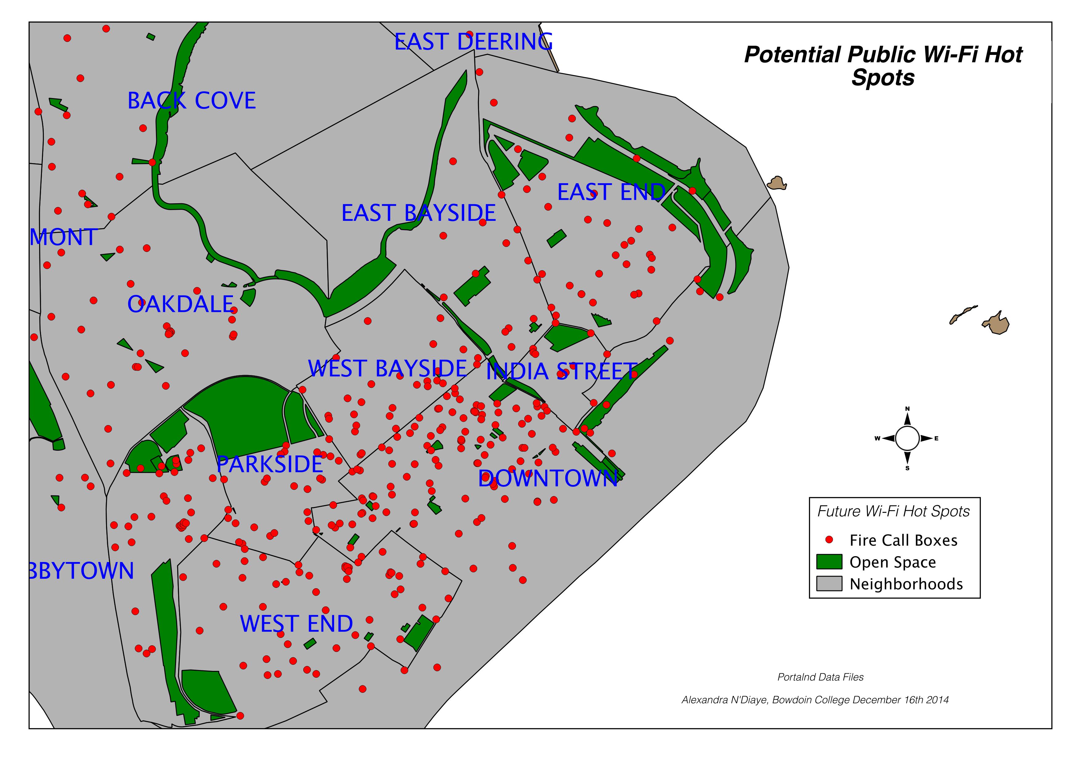
Maps were created to visualize the proposed area of development and guide planning recommendations. A map was first created to identify ISN and the future site of the Recreation Hub. Another map with a broader perspective reveals the extent and location of existing outdoor recreation space in the city, while contextualizing the Recreation Hub with respect to neighboring residential areas. The City of Portland provided data identifying the types of open space in Portland – areas identified as a trail, park, golf course, or playground were all grouped to map “recreation space”. Another map was created using data to illustrate the connection between different recreation spaces in the ISN area and the need for accessibility to the Recreation Hub. Bus route schedules were examined to understand the scope of accessibility.
Historical maps provided by the City of Portland were also referenced. These maps provided insights into how the city’s growth was fueled by the waterfront activity at the foot of India St and the commercial center of India St., Exchange St., and Middle St. Historic sources discuss the interplay between daily life in Portland and the waterfront; highlighting how it has changed from the eighteenth century to present day.
Findings
Historic maps and sources indicate that ISN’s identity as the city’s commercial center has changed over the years. Now, the neighborhood serves as a transitional area between the rapidly gentrifying neighborhood of Munjoy Hill and the tourist and commercial center of the Old Port and Commercial St. ISN lacks a sense of clear identity.
Fig 1. (Left) Portland in 1775 with India St. (King St. then) as a major artery to the waterfront. (Right) Portland in 1866 featuring the rail network along the waterfront centered at India St.[22]
As Fig 3. Illustrates, recreation space is concentrated around the Eastern and Northern edges of the city with very little in the center or along the waterfront. Piers and tightly concentrated streets dominate the waterfront. ISN is situated on the Eastern part of the city near the waterfront.
Fig 3. Recreation space (trails, parks, playgrounds, golf courses) in Portland.
Fig 4. ISN and its major streets are highlighted, along with the site for the Recreation Hub.
ISN is dominated by open space that is not used for recreation and large buildings that consist of industrial buildings, parking garages, and hotels. There is no recreation space in ISN, there are only three recreation sites located just beyond the neighborhood boundaries. Residential neighborhoods border ISN, as indicated by the many small buildings to the Northeast and Northwest.
Fig 5. Bus routes, sidewalks, and streets connecting ISN to the rest of the city.
Bus route 8, which stops at Commercial St. and India St. provides access to the Recreation Hub. However, the bus only runs every 30 – 45 minutes on weekdays and 40 – 50 minutes on Saturdays, with no service on Sundays. Major streets in the area have sidewalks, but some are disconnected in and immediately around ISN.
Discussion
My recommendations have dual aims: (1) to offer feasible solutions for transforming the open space at the foot of India St. into a Recreation Hub, and (2) to suggest the optimal planning process for engaging public participation. I recommend installing an adult workout park, a play area for children, comfortable seating, lighting, and a storm-water collection pond. My recommendation for the planning process leverages technology and the web interface to provide a highly-accessibly and interactive platform for residents to voice their opinions.
The Recreation Hub needs to be developed with the goal of maximum usership in mind. The area can establish itself as a destination that draws people to ISN and gives them a reason to stay. Currently, popular restaurants, such as Hugo’s, Duckfat, and Eventide Oyster Company located on Middle St., are the main attraction to the neighborhood. The success of these restaurants, as well as nearby shops and the popular Italian landmark, Micucci Grocery Store, has already initiated a revitalization process; however, public space is still lacking. Even more, Portland as a whole presents limited opportunities for its residents to enjoy the waterfront. The water is a valuable natural amenity whose ability to improve quality of life should be better taken advantage of. Not only can transforming the open space at the foot of India St. into a Recreation Hub provide opportunities for people to spend time near the water, but it will also provide much needed opportunities for recreation.
While Portland does have some recreation sites, they are primarily located along the North and Northeastern edges of the city. The new Recreation Hub should include a workout park for adults, consisting of stationary equipment and signage providing exercise information. The workout park should occupy no more than a quarter of the total space. A play area for children should occupy another quarter of the space. Depending on budget limitations and residents’ desires, the play area can be as simple as a paved section for chalk or a sandbox, or full on playground equipment. The children’s area should be surrounded by benches for parents to sit on while attending to their children. At least half of the space should be made of natural materials. This includes open grass patches for picnics, bushes to separate the Recreation Hub from the street, flowers, and trees to provide shade. If space permits, a pond that collects storm water and then uses it to irrigate the greenery should be installed. The pond would minimize run-off and save water, as well as create a feature that children can interact with. Seating should be positioned around the pond so people of all ages can sit and relax, enjoying the calming effects of the water.
Lighting is essential, especially given the dark days of Maine during the late fall and winter. The City of Portland should partner with students at MECA, University of Maine, Bowdoin College, and Bates College and challenge them to create public art installations in the form of solar-powered lights. Different lights can be installed each season, transforming the look and feel of the space and showcasing many different student-artists. These installations would be an ideal way to incorporate public art into the space while minimizing commissioning and electricity costs and ensuring visitors’ safety.
It is critical that the Recreation Hub is made accessible to the rest of the city, especially as the most densely populated residential areas are located beyond the boundaries of ISN. While Bus 8 stops right by the Recreation Hub site, the bus does not run frequently and does not run on Sundays. Since the Recreation Hub will be catering to all ages, family visitation rates are expected to be highest on weekends when parents have the most time to spend time with their children. It would be advisable to increase the frequency of Bus 8, and at the very least, provide service on Sundays. The surrounding sidewalk network appears to be sufficient, however, the Recreation Hub needs to meet cyclists’ needs by offering ample bike racks. The Recreation Hub should also be well connected to the preexisting recreation area of the Eastern Promenade. This lookout area attracts many visitors and the Recreation Hub could become a final destination for these people, especially runners and cyclists seeking an additional workout. Establishing this connection and then educating the public about it will be key to increasing usership.
Finally, the Recreation Hub should be multi-purpose, capable of serving as an event venue year-round. Events can integrate local private businesses, to take part in food festivals. Similar the Art Walk model, one evening each month, the Recreation Hub could invite a selection of Portland restaurants to sell a few menu items at a capped cost. Temporary seating could be set up so people could pick up food from restaurant booths and then sit and eat. Musicians could be invited to provide entertainment. The food offering could be tailored to the season – outdoor heaters and blankets, Duckfat poutine, a hot chocolate stand, and snow sculpting competitions in the winter; Nosh burgers, a lemonade stand, and popsicles in the summer. This would be a good way for ISN to engage local businesses in community-building events without giving them long-term ownership to the space.
Conclusion
The recommendations detailed in this paper provide a means for Portland to significantly revitalize ISN. GIS analysis indicates that Portland needs to expand its green space and provide increased opportunities for residents to enjoy the waterfront as a part of their daily lifestyles. If the Recreation Hub incorporates the recommended features – an adult workout park, children’s play area, seating, green space, public art solar lighting, and an irrigation pond – the space will become a prominent destination spot for both residents and tourists. What these features finally look like should be determined by public preferences. Portland can best listen to the public by establishing an online platform that anyone can easily access to voice their opinions. The platform would become a forum where people can vote on options (i.e. four options for a children’s play area), comment on proposed solutions, and even post photos of places in Portland or elsewhere explaining what they like or do not like about it. Essentially, an online “public space” should be created to develop the public space to ensure people’s needs are best met.
The design of the Recreation Hub is critical, but accessibility ultimately determines its public usage. Thus, Portland should increase its Route 8 service to the Recreation Hub, ensure sidewalks are well maintained, and create a well-marked connection to the Eastern Promenade. Public awareness about the space can be increased through newspaper articles, newscast features, and events sponsored by local businesses. The Recreation Hub can become an engaging dynamic place for people of all ages to enjoy the waterfront, play, socialize, relax, and engage with nature. In these ways, the Recreation Hub has great potential to improve people’s quality of life and well-being. The recommendations discussed in this paper ensure the Recreation Hub will ultimately Portland help further ISN towards the goals and visions outlined in the India Street Sustainable Neighborhood Plan.
Works Cited
Beatley, Timothy. Biophilic Cities. Washington, D.C.: Island Press. 2010.
Cicea, Claudiu and Corina Pîrlogea. “Green Spaces and Public Health in Urban Areas.” _____Theoretical and Empirical Researches in Urban Management 6, no. 1 (02, 2011): 83-92. _____http://ezproxy.bowdoin.edu/login?url=http://search.proquest.com/docview/858207241?acc_____ountid=9681.
City of Portland. India Street Sustainable Neighborhood Plan. September 2014. _____http://www.portlandmaine.gov/DocumentCenter/Home/View/6471.
Durgahee, Ayesha and Matthew Knight. “New Gym Turns Workout into Watts.” CNN. _____November, 27, 2011. http://www.cnn.com/2012/11/27/world/europe/gym-workout-watts-_____electricity/.
Hu, Winnie. “Mom, Dad, This Playground’s for You.” New York Times, June 29, 2012. _____http://www.nytimes.com/2012/07/01/nyregion/new-york-introduces-its-first-adult-_____playground.html?pagewanted=all&module=Search&mabReward=relbias%3As%2C%7B_____%222%22%3A%22RI%3A14%22%7D&_r=2&.
Hurst, Nathan. “Digitally Enhancing Public Spaces at the Urban Prototyping Makeathon.” _____Wired. November 6, 2012. http://www.wired.com/2012/10/up-makeathon/.
Larry, Julie and Gabrielle Daniello. History of Portland’s India Street Neighborhood. Accessed _____November 17, 2014. http://www.portlandmaine.gov/DocumentCenter/Home/View/4276.
Low, Setha M. “Spaces of Reflection, Recovery, and Resistance: Reimagining the Postindustrial _____Plaza.” in After the World Trade Center: Rethinking New York City, ed. Michael Sorkin _____and Sharon Zukin (New York: Routledge).163-172.
Perry, Tony. “San Diego’s Waterfront Makeover is Heavy on Public Space.” Los Angeles Times. _____December 8, 2014. http://www.latimes.com/local/california/la-me-san-diego-waterfront-_____20141209-story.html#page=1.
Petty, Raven. “Four Cities with Playgrounds for Adults.” Livability. November 17, 2014. _____http://livability.com/health-and-wellness/four-cities-playgrounds-adults.
Rutherford, Linda. “Why Public Places are Key for Transforming Our Communities.” Greenbiz, _____April 25, 2014. http://www.greenbiz.com/blog/2014/04/25/why-public-places-are-key-_____transforming-our-communities.
Sareen, Himanshu. “Smart Cities: A Brave New Digital World.” Wired, March 28, 2013. _____http://www.wired.com/2013/03/smart-cities-a-brave-new-digital-world/.
Schulkin, Jay. Adaptation and Well-being: Social Allostasis. Cambridge: Cambridge University _____Press, 2011.
Silberberg, Susan. Places in the Making: How Placemaking Builds Places and Communities. _____Massachusetts Institute of Technology (2013). _____http://dusp.mit.edu/cdd/project/placemaking.
Tomer, Adie and Rob Puentes. “Here’s the Right Way to Build the Futuristic Cities of Our _____Dreams.” Wired. April 23, 2014. http://www.wired.com/2014/04/heres-the-right-way-to-_____build-the-futuristic-cities-of-our-dreams/.
Van Auken, Paul, Shaun Golding, and James Brown. “Prompting with Pictures: Determinism _____and Democracy in Planning.” American Planning Association: Making Great _____Communities Happen. 2012.
[1] City of Portland, India Street Sustainable Neighborhood Plan, September 2014, http://www.portlandmaine.gov/DocumentCenter/Home/View/6471.
[2] Setha M. Low, “Spaces of Reflection, Recovery, and Resistance: Reimagining the Postindustrial Plaza,” in After the World Trade Center: Rethinking New York City, ed. Michael Sorkin and Sharon Zukin (New York: Routledge), 163-172.
[3] Adie Tomer and Rob Puentes, “Here’s the Right Way to Build the Futuristic Cities of Our Dreams,” Wired, April 23, 2014. http://www.wired.com/2014/04/heres-the-right-way-to-build-the-futuristic-cities-of-our-dreams/.
[4] Himanshu Sareen, “Smart Cities: A Brave New Digital World,” Wired, March 28, 2013, http://www.wired.com/2013/03/smart-cities-a-brave-new-digital-world/.
[5] Claudiu Cicea and Corina Pîrlogea, “Green Spaces and Public Health in Urban Areas,” Theoretical and Empirical Researches in Urban Management 6, no. 1 (02, 2011): 83-92, http://ezproxy.bowdoin.edu/login?url=http://search.proquest.com/docview/858207241?accountid=9681.
[6] Ibid.
[7] Jay Schulkin, Adaptation and Well-being: Social Allostasis (Cambridge: Cambridge University Press, 2011), 3.
[8] Claudiu Cicea and Corina Pîrlogea, “Green Spaces and Public Health in Urban Areas.”
[9] Ibid.
[10] Timothy Beatley, Biophilic Cities (Washington, D.C.: Island Press, 2010), 6.
[11] Paul Van Auken, Shaun Golding, and James Brown, “Promting with Pictures: Determinism and Democracy in Planning,” American Planning Association: Making Great Communities Happen (2012), 2.
[12] Susan Silberberg, Places in the Making: How Placemaking Builds Places and Communities,” Massachusetts Institute of Technology (2013), http://dusp.mit.edu/cdd/project/placemaking.
[13] Tony Perry, “San Diego’s Waterfront Makeover is Heavy on Public Space,” Los Angeles Times, December 8, 2014, http://www.latimes.com/local/california/la-me-san-diego-waterfront-20141209-story.html#page=1.
[14] Linda Rutherford, “Why Public Places are Key for Transforming Our Communities,” Greenbiz, April 25, 2014, http://www.greenbiz.com/blog/2014/04/25/why-public-places-are-key-transforming-our-communities.
[15] Winnie Hu, “Mom, Dad, This Playground’s for You,” New York Times, June 29, 2012, http://www.nytimes.com/2012/07/01/nyregion/new-york-introduces-its-first-adult-playground.html?pagewanted=all&module=Search&mabReward=relbias%3As%2C%7B%222%22%3A%22RI%3A14%22%7D&_r=2&.
[16] Raven Petty, “Four Cities with Playgrounds for Adults,” Livability, November 17, 2014, http://livability.com/health-and-wellness/four-cities-playgrounds-adults.
[17] Tony Perry, “San Diego’s Waterfront Makeover is Heavy on Public Space”.
[18] Ayesha Durgahee and Matthew Knight, “New Gym Turns Workout into Watts,” CNN, November, 27, 2011, http://www.cnn.com/2012/11/27/world/europe/gym-workout-watts-electricity/.
[19] Linda Rutherford, “Why Public Places are Key for Transforming Our Communities”.
[20] Nathan Hurst, “Digitally Enhancing Public Spaces at the Urban Prototyping Makeathon,” Wired, November, 6, 2012, http://www.wired.com/2012/10/up-makeathon/.
[21] Julie Larry and Gabrielle Daniello, History of Portland’s India Street Neighborhood, accessed November 17, 2014, http://www.portlandmaine.gov/DocumentCenter/Home/View/4276.
[22] Julie Larry and Gabrielle Daniello, History of Portland’s India Street Neighborhood
Early Warning Weather System
[gview file=”https://courses.bowdoin.edu/digital-computational-studies-2430-fall-2014/wp-content/uploads/sites/52/2014/12/Early-Warning-Weather-Sensor-System-Portland-small.pdf”]
Security in Portland as a Smart City
[gview file=”https://courses.bowdoin.edu/digital-computational-studies-2430-fall-2014/wp-content/uploads/sites/52/2014/12/NDiaye_finalPaper_Part11.docx”] [gview file=”https://courses.bowdoin.edu/digital-computational-studies-2430-fall-2014/wp-content/uploads/sites/52/2014/12/NDiaye_FinalPaper_Part21.docx”] [gview file=”https://courses.bowdoin.edu/digital-computational-studies-2430-fall-2014/wp-content/uploads/sites/52/2014/12/NDiaye_FinalPaper_Part3.docx”] 

Improving Portlands Public Bus System – Final Research Paper
Improving Portland’s Public Bus System
Konstantine Mushegian
The Digital Image of the City – INTD2430
Professor Jen Jack Gieseking
Abstract
This paper addresses the issue of public transportation in Portland, Maine and offers smart city solutions and policy recommendations that will improve the existing transit system. Technological solutions and policy recommendations proposed at the end of this paper will aim to reduce commute times through the intelligent bus stop placement. Optimal bus stop locations will reduce the average walking time to the bus stop, thus making the public transportation system more accessible and attractive for residents and visitors alike. Portland’s Comprehensive Plan website has only one document that addresses the issues of public transportation in and around the City of Portland. “A Time of Change: Portland Transportation Plan” was proposed to the City Council in July of 1993 by a “Committee of Citizens” [1] but the majority of issues brought up in the plan still seem to exist, almost twenty-two years later. The plan to overhaul Portland transit system that was put together by citizens addresses and tackles issues of intra- neighborhood and inter-neighborhood transportation but no significant changes have been made since 1993. The fact that nothing of importance has been changed is also reinforced by the fact that the only document on the Comprehensive Plan website that touches upon the issues of public transportation is from 1993. I have been regularly reading the minutes from the meetings of the Portland City Council Committee on Transportation, Sustainability and Energy (TSE) for the past couple months. The issue of bus stop placement was brought up at the TSE meeting on September 27, 2014 and a request for proposals was issued in the same month for a Hub Link Feasibility Study in order to “evaluate feasibility of transit routes which will best improve connections between local and regional transportation terminals and major points along the corridors connecting them”[2] but no proposals were received by the deadline of October 17th.

The lack of proposals indicates the inactivity and nonchalance of residents and commuters who are affected by the issue the most. In addition, I will also offer suggestions on how to improve citizen involvement in public issues in this paper.
Continue reading Improving Portlands Public Bus System – Final Research Paper
“MyTree Portland”: Incentivizing Private Investment in the Betterment of Public Spaces
[gview file=”https://courses.bowdoin.edu/digital-computational-studies-2430-fall-2014/wp-content/uploads/sites/52/2014/12/DIOTC-Final-Paper.docx”]
Public Space: Final Research Paper
Portland, Maine: A ‘Walkable’ but ‘Seatable’ City?
An Analysis of the Public Seating Available in Portland and Policy Suggestions to Increase Public Seating for the Common Good
Jackie Sullivan
December 17, 2014
Research Question
One of the most highly valued yet often underrated experiences of a city is sitting in a public area and watching the world pass by. This experience is very telling of the culture of a city, and is not always observable by walking or driving. Sitting in a public place can be an activity for tourists, residents, and commuters alike, always offering a refreshing perspective. In order to increase the usage, accessibility, and efficiency of public space throughout Portland, I propose a policy that will increase public seating to make public space more accessible to all. Although a simple proposition, it is extremely significant and can have amplified effects for the culture of the city. Not only will this encourage people to occupy public spaces more often, increased public seating will also foster a sense of community. Portland will become a city of sitting, enjoying, observing, and absorbing, and will not be for the passerby’s. In order to implement this proposal into the idea of the smart city, becoming increasingly relevant with technological growth, I propose implementing seating with warming features. This will allow people to continue to take advantage of public space during the cold winter months, and will create a greater sense of community throughout Portland all year long.
Approach to the Common Good for the City
Significant policy recommendations for Portland must be applicable to the common good. The common good can easily be promoted through public space and can be simplified to embody equal accessibility to all. Available public seating is an important component of accessibility. Although Portland is fairly walkable, a technical definition of “walkability” includes components of physical access, proximity, and places.[1] It has been shown that people are willing to make tradeoffs between house size and price for the benefit of “walkable” neighborhoods.[2] Public seating provides a convenient resting stop between places, offering physical access as a means to enjoy public space. According to “Walk Score”, which measures the walkability of locations based on pedestrian friendliness and proximity, Portland has a walk-score of 57, meaning it is “somewhat walkable and some errands can be accomplished on foot.”[3] The most walkable neighborhoods were identified as West Bayside, East Bayside, India Street, and Park Side. From the transect walk I completed throughout the West End, I know that walkability can be improved. My policy recommendation of increasing public seating benefits the common good throughout Portland.
Approach to the Smart City
This policy proposal can be implemented into nearly any city. Some cities are “smarter” than others, but all could benefit from an increase in public seating. Although Portland, in comparison to a city such as Songdo, is not “smart” by certain definitions, technology is beginning to gain a larger presence. As Greenfield discusses, smart cities can refer to retrofitting networked information technologies into existing urban places.[4] In Portland, an urban area, the only missing segment is the use of technology. I recommend implementing technology to ensure public seating is available to residents all year long. Integrating warming features will allow public seating, for instance benches, to always be used. Even when snow and ice take over the city of Portland, access to public space should not be limited. In the long winter months in Maine, the snow and ice will melt so people will still be able to access benches in public space.
This is a similar strategy to heating benches in the NFL. While the purpose of heating benches in stadiums is to keep the players warm, it uses a similar method. Frank Floyd Jr.’s Reliable Construction Heaters of Cleveland makes these heated benches, which can now be found in 16 different football stadiums in the US.[5] These benches are heated using propone or natural gas blowers, allowing the players to maintain a comfortable body temperature.[6] This same idea can be taken to heating public benches in Portland, at a much lower level of power. This warming ability could increase the use of public seating in the winter months since it would allow people to access them even in the snow. Although costly, it is something worth exploring since it enhances the city experience. By melting snow and ice, the probability that public seating structures will be damaged from winter weather conditions decreases. This benefit means public seating will last longer than those seats that are damaged during the winter, and it can be argued that the payoff of heating public seating is worth the initial investment.
Increased public seating can also be used in another technological capacity. When new public seats are created, their locations can be added as a data layer to future applications and maps of the city, which is currently unavailable. Seating is not taken advantage of because people are unaware of where public seating is located. If this data is added to maps and other pieces of information about the city, people will increase their use of public spaces.
Literature Review
Many pieces of literature, both academic and media driven, discuss the use of public space, particularly in relation to seating. Beginning with William Whyte’s video on public space from 1988, he observed that the use of public space is directly dependent on the availability of usable public seating.[7] Although people are innovative and use structures that are not explicitly created as seats, they are not willing to invest large amounts of effort to create these opportunities. It is clear from Whyte’s research that the public greatly depends on convenient seating. Other studies show that seating does not need to exist in the form of benches or chairs. There are innovative creations of such seating and objects in public space that can serve multiple functions. For instance in a review of public space in New York City, there are granite planters surrounded by ledge seating and metal rails at a location near Fulton Street.[8] Additionally, Tony Rosenthal’s Steel Park is on East 80th Street, which provides a collection of metal panels and shapes, also doubling as seats.[9] There are many instances where the objective of increasing public seating can be achieved without designing specific seating installments, but rather allowing for creative freedom.
Seating is further examined through John Perrem’s research at the Architectural Association of Ireland (2009). Perrem describes that “areas where people sit act as nodes of stillness in a sea of movement and flux.”[10] He believes that sitting in a public space offers a new understanding of an area. It is a necessary part of society to create an accurate experience of the city, prompting the need and desire for seating. Perrem agrees that creative installments are a good way to implement the element of seating into public space, and he discusses informal versions of seating as alternatives to benches.[11] Both Perrem and philosopher Gilles Deleuze, as cited by Greenfield, recognize the connections that public seating creates among people and with the surrounding space, sights, sounds and smells.[12] There is an additional sense of community that comes with public space creation and it is clear that many researchers believe public seating enhances the use of public space. Elet offers a historical view of public seating, providing analysis of the form and the function of public seating influencing urban environments.[13] He claims that benches carefully integrated into public space do so purposefully with the intent of bringing out culture, ever since ancient Greece.[14] Clearly, there has been great importance placed on public seating throughout history, showing its significance on the formation of societies.
Lefebvre introduces his idea of the “right to the city” when he discusses that cities are part of public space.[15] This can directly relate to the common good since there is joint ownership among everything in the public sphere, and nobody should be excluded. Low has similar ideas when he discusses the five qualities of spatial rights: freedom of access, freedom of action, freedom to claim, freedom to change, and freedom of ownership.[16] All of these ideas have influence when defining what public space encompasses. This promotes large debate, and Perrem discusses the rise of pay-to-sit locations and the decrease of free public seating.[17] He claims this phenomenon is a result of the increase of city life and the corresponding decrease in value people place on a city. This causes those who cannot afford to pay for seating to be excluded from public spheres.[18] The rise of this issue causes a direct violation of Lefebvre and Low’s principles, which should always exist in public space.
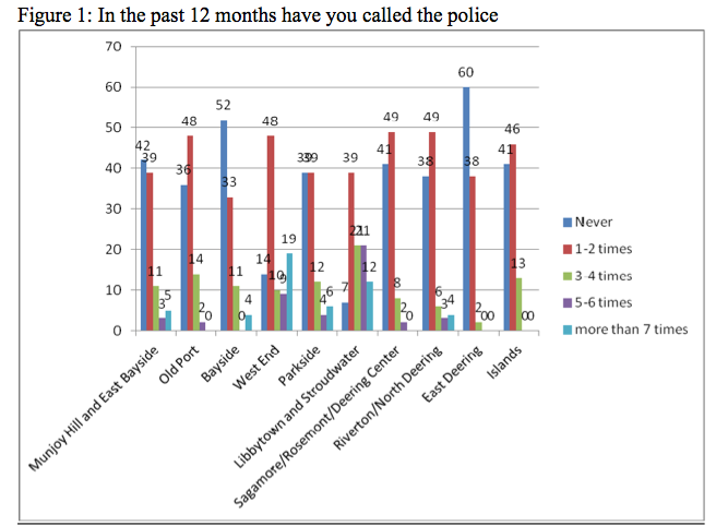
There is also an increased discussion of these issues surrounding public space in the media world, particularly with the rise of technology. In San Francisco, there has been a recent push for increased public seating to encourage more people to spend time in the city.[19] Over the past two decades, there have been movements to decrease public seating due to their serious problem of homelessness. Most public benches were removed throughout San Francisco since they had become spaces for the homeless to congregate.[20] However with the reinstallation of seating in recent years, following an increase in efforts addressing homelessness, the future of San Francisco’s public space is promising. This is something that needs to be taken into consideration in Portland. Portland has a large population of homeless people and there is always the risk that they will gather in public areas with seating. Places like Preble Street are contributing much time and energy to alleviate the problem of homelessness throughout Portland. However, the amount of homeless people in Portland is continuing to rise, with an average of 434 people seeking shelter each night in October 2012.[21] Although increasing public seating potentially creates a place for congregation, the benefits of creating usable public space for the rest of the city outweigh this risk. Portland, a much smaller city than San Francisco, needs to focus on creating public seating for the common good, while simultaneously combatting homelessness.
According to the Portland Comprehensive Plan, the section titled “Green Spaces, Blue Edges” discusses various recommendations in terms of creating and maintaining usable public space to benefit all demographics.[22] There is a specific goal outlined to foster public-private partnerships to increase the resources available to residents in public parks and maintain the care of such public spaces. With the revival of “Green Spaces, Blue Edges” in 2001, there was an increased emphasis on refurbishing walkways and infrastructure located in public green spaces in order to make them more usable and desirable for the public.[23] Increased seating was mentioned in this policy document, although not a clear priority, highlighting a weak portion of the plan. Rather than pushing corporations to increase infrastructure in parks, I recommend encouraging artists to design infrastructure for public parks in the form of creative seating. This promotes the art culture that already occupies a big part of Portland, rather than corporate branding. Many are enthusiastic about continuing to find new ways of implementing art into every day life, and this provides ample opportunity.
Along the same lines, there have been recent initiatives throughout Portland integrating art into the creation of public space. Just this past spring the SPACE Gallery in conjunction with Congress Square Park, commissioned artist Michael Klyde Johnson to design and construct a form of public seating to increase the use of the Park.[24] Currently, Johnson’s structure provides the basis for seating and largely increased the use of this public area when the structure was introduced just this past summer. A similar initiative occurred in 2011 with the intention of holding a competition for the design of public seating to be installed along the Bayside Trail through the Portland Public Art Committee (PPAC).[25] Three locations were chosen for the public seating installments, with goals of enhancing the Bayside Trail experience, engaging the public, providing year-round, easily maintained, and long-lasting functional public art in the form of seating (Figure 5).[26] The final budget of $42,500 was intended to fund three public seating clusters and could be distributed to up to three designers.[27] Although in the end the PPAC did not reach a conclusion to proceed, they made significant progress in promoting the idea of public functional art.[28]
I recommend that Portland revisit this competitive nature to create public seating and foster a sense of community. It would be beneficial for such institutions as the SPACE Gallery or MECA to assist in these competitions to ensure the quality of work submitted would be effective, aesthetically pleasing, useful, and fulfill all of the requirements outlined – something which the 2011 competition lacked. Portland has tested this idea before and I would encourage the city to do so again. Very recently, a report was released from the Congress Square Redesign Study Group, which outlined two concepts for Congress Square Park, an area in need of redesign to ensure sustainability.[29] These two ideas stem from either a redesign of a public park built by the city at the cost of $1 million to $1.5 million from taxpayers, or a public-private partnership with the Westin Harborview Hotel combining a park and event center.[30] The City Council will review these two plans, however the Redesign Group already expressed favor towards the park only idea, after a very split vote. The goals of these ideas are to improve public space, as well as increase the value of the Congress Square neighborhood, which has economic benefits for the entire city.
All of these pieces of literature help relate to the image of public space, particularly through past initiatives, studies, and current state of affairs within Portland. Public space is clearly a defining feature of a city and it is important to be able to improve and promote such through increased public seating.
Methods
My inspiration for this policy recommendation began after I saw William Whyte’s video on the influence seating had on public space. I became particularly aware of this feature of public space during my transect walk in the West End neighborhood of Portland on November 24, 2014. Taking note of both the existence and lack of available public seating, I was inspired to learn more about how Portland could increase this component, especially in parks where seating is often taken for granted. I noticed the unpleasant appearance of many of the benches in the West End, which inspired me to integrate artistic competitions and technology into my policy suggestion. I took detailed notes during my time in Portland and recorded the locations of public seating, as well as took pictures of structures that could act as such. I only noted six benches in the Western Promenade and seven benches in Deering Oaks Park, which is a shockingly low number for such large green spaces. This experience provided the primary foundation for my research.
In order to create the most comprehensive and complete view of what policies I should encompass, I looked at many data sets describing the city of Portland. In particular, I used the City of Portland 2014 shape files to create maps on QGIS, including open space, streets, and ocean layers. During my transect walk I recorded the longitude and latitude of benches throughout the West End and I was able to utilize data that Luis Panaigu recorded of seating on East Congress Street, which I have mapped in Figure 1. I also looked at the available areas of green and open space, which are areas that public seating could easily be implemented. Since parks and open spaces exist throughout the city, it makes most logical sense to begin implementing public seating in these areas first. I have mapped suggestions for increased public seating in Figure 2. Although this is not exhaustive, it is a good start to my policy implementation. Since certain demographics impact the use of public space more than others, I looked at the median age for Portland residents in Figure 3, leveraging Portland’s Public Map Gallery. The elderly are more inclined to require seating than younger generations, since they are unable to walk around the city unassisted. A large population of elderly would create reason for an increase in public seating, something I accounted for when making my bench location suggestions. I chose not to look at the population of homeless people in Portland when conducting this research. Although a large amount of homelessness could mean a higher probability of inappropriate use of public space, the efforts of Preble Street have helped eliminate this detail so it does not have a substantial influence the placement of public seating. The benefits of increased seating much outweigh the risks of potential inappropriate use of public seating by these demographics.
Findings
As I began to look for data layers pertaining to public seating, it was clear that nobody has previously attempted to create such data about public seating. I used the locations of benches in the West End which I had recorded, with an emphasis on the Western Promenade and Deering Oaks Park, and leveraged the data that Luis Panaigu collected of benches on East Congress Street. Figure 1 provides an accurate map of observed benches. Although it is not inclusive of all the benches across the city, it is telling of the lack of benches in certain areas and the need for more data collection on this topic.
Figure 1:
Using background research and observations in the West End, I have mapped suggested locations for seating in addition to the existing locations in Figure 2. I was particularly struck by the lack of benches surrounding the pond in Deerings Oak Park and would like to see an improvement of public seating in this area. This implementation will allow the public to enjoy the park and in particular the pond more easily and often.
Figure 2:
To increase my knowledge about the relative demographics of Portland, I leveraged the map represented in Figure 3 from Portland’s Public Map Gallery. The blue coloring represents older ages who are particularly volatile to the lack of seating throughout Portland.
Figure 3:
Map of 2010 Median Age Distribution throughout Portland
Source: Public Map Gallery, City of Portland, ME[31]
Something that caught my eye specifically in the Western Promenade was the state of the benches that were available. They were rickety and falling apart, not where I would picture myself sitting for a prolonged amount of time. This helped inspire my recommendation for seating combined with public art.
Figure 4:
Bench located in the Western Promenade, Portland, ME
Source: Jackie Sullivan, Transect Walk, November 24, 2014
In my research I found a map of proposed seating installment locations from the competition conducted by the Portland Public Art Committee in 2011. Although this initiative was never completed, there has clearly been some thought about where proper seating installments would benefit the public, which I would like to see revisited. Below is one of the three proposed locations.
Figure 5:
Map of Proposed Seating Installment Locations following Creation of Artistic Competition
Source: Portland Public Art Committee: Bayside Trail Seating Project, 2011[32]
Reflections/Discussion
All policy proposals for Portland should benefit the Common Good; providing equal access to all is one of the only ways that large investments can be justified. In order to ensure that all members of Portland, regardless of age or demographic, have equal access to the city experience, I propose increasing public seating throughout Portland. Although rather basic, this creation can transform the experience of Portland. Public seating is often taken for granted, but when there is a shortage of public seating it is extremely noticeable and inconvenient. After completing my transect walk in the West End, I noticed the extreme lack of public seating in terms of physical structure, as well as the lack of maintenance of public seating. The benches located along the Western Promenade were falling apart and there were no visible efforts of improvement (Figure 4). Similarly in Deering Oaks Park, none of the benches seemed to be matching and they were all run-down. Although this proposal requires a large initial investment and continued maintenance costs, I believe that it can truly enhance the experience of the city and encourage those to spend more time in public space throughout Portland.
As a way to encourage community involvement and bring enjoyment to the creation of public seating, I recommend creating art competitions surrounding the design of public seating. A similar competition was conducted in 2011 among artists to design public seats along the Bayside Trail in Portland.[33] This creates both opportunities for artistic freedom and produces public art in addition to usable and unique public seating. Figure 5 represents a map of where the public seating was suggested following the 2011 competition. Public space very much involves a sense of community, which nicely coincides with this friendly competition in the creation of public seating for the use of public space.
In order to implement technology to help Portland move in the direction of a smart city, I would recommend installing warming features in order to allow public seating to be accessible all year. In the winter months snow and ice prevent benches from functioning, but if there were features that melted this away, the public could still take advantage of seating and continue to enjoy public space. Despite the large costs that this could incite, the benefits of continued enjoyment from the public would surpass the cost. With the melting of snow and ice the public seating structures would be better protected from weathering. The benches in the Western Promenade (Figure 4) clearly were weathered and not well maintained, but the warming features could alleviate at least a portion of this problem.
To begin, I think it is most logical to increase public seating in the parks throughout Portland. Deering Oaks Park specifically caught my attention during my transect walk, since there were only a few benches that were placed in odd locations and did not seem usable. It would make most sense to begin increasing public seating throughout parks, such as Deering Oaks Park. There is a wonderful pond in the middle of this park, however it cannot even be enjoyed since there are no benches surrounding it. Increasing public seating in green and open spaces should be the first priority of the city in order to increase public traffic in these areas. I have mapped open spaces in Figure 2 to highlight areas of opportunity. This project should not be limited to parks however, and unique seating structures should be installed throughout the city. Along streets, in the historic district, and in the many squares throughout Portland, anything will be utilized.
This proposal especially influences the elderly who are not able to enjoy walking the entire city, despite Portland’s relative walkability. It would be best to increase seating where there are higher populations of elderly people (Figure 3) as well as areas where they likely to go, often public parks. With Maine having the highest population of baby boomers, an age demographic that is increasingly in need of assistance in the form of seating, this should become a focus for Portland.[34] Many cruise ships dock within walking distance of the Portland Art District and the Old Port.[35] Although claiming that the entire city is walkable, the demographic that is typically found on cruise ships could especially benefit from an increase in public seating.
Conclusion
Overall, my recommendation to increase public seating seems to provide a wide range of benefits to many different demographics of Portland. It increases not only the desire to occupy public space, but it allows for all people to have equal opportunity to do so. It is truly a suggestion for the common good. Having spent a semester in Europe I thoroughly enjoyed sitting in public areas in every city that I visited and came to enjoy all that I learned about the city’s culture and the people through the power of observation. With an increase in public seating throughout Portland, this too can be possible. For residents, commuters, and tourists alike, there are many people who would enjoy this opportunity, especially if equipped with warming features for the wintertime. It is clear from many of the mental maps collected that people are attune to the desire for an increase in usable public space, and this is an accurate mean to achieve this greater objective.
Works Cited
“Arriving via Cruise Ship.” Official Travel of Site for the Greater Portland Region. Accessed December 14, 2014. http://www.visitportland.com/cruising-to-portland-maine.aspx.
Bouchard, Kelly. “Maine summit tackles challenge of aging population.” Maine Press Herald, January 17, 2014. Accessed December 5, 2014. http://www.pressherald.com/2014/01/17/ maine_summit_on_aging_under_way_in_augusta/.
City of Portland MIS Division. “Public Map Gallery.” 2012. Accessed December 10, 2014. http://click.portlandmaine.gov/GISPortal/
Elet, Yvonne. “Seats of Power: The Outdoor Benches of Early Modern Florence.” Journal of the Society of Architectural Historians 16, 4 (2002): 444-469.
Elinson, Zusha. “A Renewed Public Push for Somewhere to Sit Outdoors.” The New York Times, January 28, 2012. Accessed December 10, 2014. http://www.nytimes.com/2012/01/29/us/in-san-francisco-a-push-for-public-benches.html?module=Search&mabReward=relbias%3Ar.
Greenfield, Adam. 2013. “What is the Smart City?” Against the Smart City. 1.3 edition.
“Green Spaces, Blue Edges: An Open Space and Recreation Plan for the City of Portland.” Portland’s Comprehensive Plan, 2001. Accessed December 10, 2014. http://www.portlandmaine.gov/DocumentCenter/Home/View/3380.
Hewins, Steve, and William Becker. “Maine Voices: A public-private partnership would make the best Congress Square.” Maine Press Herald, December 11, 2014. Accessed December 14, 2014. http://www.pressherald.com/2014/12/11/maine-voices-a-public-private-partnership-would-make-the-best-congress-square/.
Kayden, Jarold S. “Privately Owned Public Space: The New York City Experience.” John Wiley and Sons, Inc. New York City (2000): 1-349.
Koenig, Seth. “Is Portland ‘too attractive’ to homeless people?” The Bangor Daily News, December 21, 2012. Accessed December 12, 2014.
Lavey, John and Jennifer Hill. “What is Walkability?” Community Builders: The Business of Building Stronger Communities, February 2, 2014. Accessed November 17, 2014. http:// communitybuilders.net/walkability/.
“Living in Portland.” Walkscore, 2014. Accessed November 20, 2014. https:// www.walkscore.com/ME/Portland.
Low, Setha M. 2002. “Spaces of Reflection, Recovery, and Resistance: Reimagining the Postindustrial Plaza.” In After the World Trade Center: Rethinking New York City, edited by Michael Sorkin and Sharon Zukin, 163-172. New York: Routledge.
Mitchell, Don. 2014 [2003]. “To Go Again to Hyde Park: Public Space, Rights, and Social Justice.” In The People, Place, and Space Reader, edited by Jen Jack Gieseking, et al, 192-196. New York: Routledge, 2014.
Newcomb, Tim. “How NFL Fields, and Players, Stay Warm in January Games.” Popular Mechanics, January 6, 20120. Accessed December 9, 2014. http://www.popularmechanics.com/ outdoors/sports/football/how-nfl-fields-and-players-stay-warm-in-january-games.
Perrem, John. “The Importance of Seating in Local Public Space.” Building Material, 18 (2009): 70-71.
Pringle, Anne. “Maine Voices: ‘Art Benches’ would show Portland’s commitment to public art.” Maine Press Herald, February 1, 2011. Accessed December 10, 2014. http://www.pressherald.com/2011/02/01/art-benches-would-show-portlands-commitment-to-public-art_2011-02-01/ .
Public Art Portland Maine. “Bayside Trail Seating Project: Request for Qualifications.” March 21, 2011. Accessed December 12, 2014. http://portlandmaine.gov/DocumentCenter/View/2942.
SPACE Gallery. “Untitled Patio with Benches and Planter.” Accessed December 10, 2014. http://www.space538.org/exhibitions/untitled-patio-benches-and-planter.
Whyte, William H. “The Social Life of Small Urban Spaces.” (1988). Internet Archives. Accessed November 17, 2014. https://archive.org/details/SmallUrbanSpaces.
[1] Lavey, John and Jennifer Hill. “What is Walkability?” Community Builders: The Business of Building Stronger Communities, February 2, 2014. Accessed November 17, 2014. http:// communitybuilders.net/walkability/.
[2] Ibid.
[3] “Living in Portland.” Walkscore, 2014.
[4] Greenfield, Adam. 2013. “What is the Smart City?” Against the Smart City.
[5] Newcomb, Tim. “How NFL Fields, and Players, Stay Warm in January Games.” Popular Mechanics,
[6] Ibid.
[7] Whyte, William H. “The Social Life of Small Urban Spaces.” (1988). Internet Archives.
[8] Kayden, Jarold S. “Privately Owned Public Space: The New York City Experience.” John Wiley and Sons, Inc: 103.
[9] Ibid, 276.
[10] Perrem, John. “The Importance of Seating in Local Public Space.” Building Material, 18 (2009): 70.
[11] Ibid, 71.
[12] Greenfield, Adam. 2013. “What is the Smart City?” Against the Smart City.
[13] Elet, Yvonne. “Seats of Power: The Outdoor Benches of Early Modern Florence.” Journal of the Society of Architectural Historians: 444.
[14] Ibid.
[15] Mitchell, Don. 2014 [2003]. “To Go Again to Hyde Park: Public Space, Rights, and Social Justice.” In The People, Place, and Space Reader, edited by Jen Jack Gieseking, et al, 192-196. New York: Routledge, 2014.
[16] Low, Setha M. 2002. “Spaces of Reflection, Recovery, and Resistance: Reimagining the Postindustrial Plaza.” In After the World Trade Center: Rethinking New York City, edited by Michael Sorkin and Sharon Zukin, 163-172. New York: Routledge.
[17] Perrem, John. “The Importance of Seating in Local Public Space.” Building Material, 18 (2009): 70.
[18] Ibid.
[19] Elinson, Zusha. “A Renewed Public Push for Somewhere to Sit Outdoors.” The New York Times, January 28, 2012.
[20] Ibid.
[21] Koenig, Seth. “Is Portland ‘too attractive’ to homeless people?” The Bangor Daily News, December 21, 2012.
[22]“Green Spaces, Blue Edges: An Open Space and Recreation Plan for the City of Portland.” Portland’s Comprehensive Plan, 2001.
[23] Ibid.
[24] Space Gallery, “Untitled Patio with Benches and Planter.”
[25] Public Art Portland Maine. “Bayside Trail Seating Project: Request for Qualifications.” March 21, 2011.
[26] Ibid.
[27] Ibid.
[28] Pringle, Anne. “Maine Voices: ‘Art Benches’ would show Portland’s commitment to public art.” Maine Press Herald, February 1, 2011, 2.
[29] Hewins, Steve and William Becker. “Maine Voices: A public-private partnership would make the best Congress Square.”
[30] Ibid.
[31] City of Portland MIS Division. “Public Map Gallery.” 2012.
[32] Public Art Portland Maine. “Bayside Trail Seating Project: Request for Qualifications.” March 21, 2011.
[33] Public Art Portland Maine. “Bayside Trail Seating Project: Request for Qualifications.” March 21, 2011.
[34] Bouchard, Kelly. “Maine summit tackles challenge of aging population.” Maine Press Herald, January 17, 2014.
[35] “Arriving via Cruise Ship.” Official Travel of Site for the Greater Portland Region.
Rebuilding and Reutilization: Revitalization of Portland Piers
https://drive.google.com/folderview?id=0B2vvrbJ-N-zDUE5UQksxMFNXZUk&usp=sharing
Rebuilding and Reutilization: Revitalization of Portland Piers
Research Topic
This paper argues that one of the most crucial and feasible infrastructure projects for the City of Portland, Maine, is the rebuilding, repurposing, and ultimately the revitalization of piers in the Downtown or “Old Port” district. The utilization of the piers through the development of public green space (a “pier park”), and residential and commercial real estate would have the most direct economically and socially beneficial impact on the city, specifically the Old Port. I propose redeveloping the properties into multiple public and private spaces with the intention to alleviate the concerns of a lack of public space and underutilized valuable waterfront real estate. This paper argues that the implementation of technologically forward-thinking power systems as well as data collection and monitoring systems will push Portland into the “Smart City” era. Portland has recently revamped its rules and regulations regarding the existing piers, and several businesses have capitalized on the exclusive real estate, but much more needs to be done to complete the transformation of Portland’s Old Port piers.
Approach to the common good for the city
The piers of the Old Port are some of the most feasible locations to implement changes benefitting the common good, due to their current run-down condition and proximity to the highly trafficked and desirable commercial region of the Old Port. The proximity of the piers to the burgeoning and gentrifying neighborhoods of downtown Portland promises increased public demand and economic investment. The redesign of the piers as an extension of the existing waterfront park system, new housing development, and business and restaurant center would directly benefit the Common Good by encouraging physical wellness and economic development. The new pier park would be a resource for free physical (and subsequently emotional) wellness to all visitors. Office space, restaurants, and retail shops would build the local economy, due to the piers’ proximity to the downtown neighborhoods and business district of Portland. Currently, however, they offer no access, claim, change, or ownership to those of lower classes.[1] A seafood market, arguably pricey, and a high-end tote bag shop were noteworthy businesses currently inhabiting one pier. Another pier has only a few pricey apartments. My proposed plan would at least extend the rights of access and wellness for those less privileged.
Approach to the smart city
Sensors and networks of sensors are a “key requirement for the delivery of Smart Environments”, but they are disruptive to install on existing systems/buildings.[2] Powerwise Systems, a Maine business, was started specifically to produce the types of sensors and monitoring equipment able to be installed into pre-existing infrastructure. The systems provide “circuit-level electrical monitoring; remote HVAC and lighting controls; building environment monitoring; performance measurement for PV, solar thermal, heat pumps, energy-recovery ventilators (ERV/HRV); and a variety of flow, fluid level, water, and gas monitoring.”[3] Access to this knowledge would encourage less wasteful behavior, thereby creating a healthier environment and benefiting the common good. It seems obvious that, with these systems already designed and able to be easily installed, the City of Portland should invest in systems. The systems should be installed in City buildings; businesses can nail down machines, practices, or groups that are particularly inefficient; landlords can pinpoint wasteful renters, and even specific rooms that need work; and individual homeowners can control their living spaces from-away to minimize their effect on the environment and the strain on their wallet. The rapid progression of technology is now making it possible to control and monitor these systems from a mobile device, encouraging around-the-clock watchfulness and accountability. However, with a newly installed Powerwise monitoring system comes large-scale data collection and analysis. According to Crowley, Curry, and Breslin, data aggregation from separate existing public systems is a logistical nightmare.[4] In addition, data analysis of citywide, national, international, or global data sets is a monumental task requiring lots of time on specialized high-computing systems run by data and statistical specialists.[5],[6] Ultimately, this means that the tremendous amount of data produced by the system of sensors will need to monitored for specific measurements, trends, or anomalies, with the caveat that much of the generated data from these sensors will go unused for years before computing power rises to levels able to handle current and past data simultaneously.
Literature review
There has been much discussion around the topic of redeveloping and reutilizing existing infrastructure, a small selection of which I will touch on in this short proposal. In his essay “Traffic in Democracy”, Michael Sorkin describes the American growth ideal of “sprawl without end” as having “escaped rational management.”[7] The Downtown of Portland has a different problem, however; located on a peninsula, sprawl and outward growth are not possible. In this case it becomes crucial either to build up, as most large cities opt for, or to repurpose existing infrastructure. This paper points to the London Docklands and New York City’s Hudson River Park as two notable examples of rebuilding, reutilization, and, ultimately, revitalization.
In NYC it is clear that space limitations drove development up; but NYC was obsessed with “NEW, BETTER, DIFFERENT!” Portland and many other cities don’t have the capital, capabilities, or desire to follow that building plan, and should think instead about how to reuse existing infrastructure. Hudson River Park in NYC has been heralded as “the model for New York City parks to come” and “the most significant new public space since Central Park.”[8],[9] Built out of the failed Westway highway project, development of the park was started in 1998 and is approximately 70% complete today.[10] Transformed from decaying piers and parking lots, it is the second largest park in the city after Central Park, encompassing 550-acres and offering over thirty different activities.[11] It is also the largest waterfront park in the United States and hosts 17 million visitors annually.[12]
The Docklands in the outskirts of London were “the old spaces, liberated from their traditional activities and lying derelict and unwanted, [that needed to] be recycled to meet the needs of the new economic world.”[13] Slow abandonment after changes in shipping vessel size rendered the docks obsolete; it took tens of years, millions of dollars, and a bevy of government and public groups to rebuild and revitalize the Docklands. The region now houses the “engine-rooms of twenty-first century business.”[14] In fact, due to the many banks and other economically important businesses in the area, Canary Wharf now rivals London as a financial stronghold.[15],[16] The current economic importance of the Docklands, the region’s architectural transformation from rough industrial and manufacturing buildings to clean-cut skyscrapers of international business, and the discovery of the necessity of cooperation has made the 30-year development a case study of urban revitalization. Against all odds, the London Docklands “wasteland” has become a “Wall Street on Water.”[17]
Setha Low argues that the privatization and commercialization of public spaces is necessary to their future and points out that they induce an expected level of class in the public space.[18] By allowing more non-marine groups and providing economic incentives for businesses, Portland could also develop the piers into an exceptional extension of the already existing waterfront park system. While this privatization may seem to subvert the “right to the city” as Lefebrev puts it, or “the right to sleep unmolested in a city park”, as Mitchell suggests, I argue that the piers as they now stand offer even less right to the underprivileged.[19] In their current ramshackle state, the piers are targets for tighter scrutiny and do not allow public access, excepting the road, thereby making it difficult for the underprivileged to access the waterfront or stake any claim in the space. By creating a public green space and improving the overall conditions of the piers, Portland simultaneously will provide an opportunity for the “right to the city”.
Rebuilding infrastructure requires more than clever engineering as Michael Sorkin tells us in his essay “Traffic in Democracy”: “It has to be thought through politically… rather than approached as merely a set of technical problems.”[20] Since the 1980s when condominiums were built on Chandlers’ Wharf in the Old Port, city policy has restricted development and occupancy to a working waterfront. However, given recent policy changes allowing “up to 45 percent of the ground floor to… non-marine tenants”, the door is slightly more open for other offices and businesses to move into these prime waterfront locations.[21] These business opportunities should be quick to be filled, but the marine spaces remain available due to a deflating ecosystem and therefore decreasing numbers of fishermen and other traditional Maine marine business. Fortunately, there is business called the New England Ocean Cluster proposed on the neighboring Maine State Pier that would fit the marine requirement and greatly benefit the region.[22] While this business would be a great boon for the piers and the City, this is only one of many available marine spaces, and much more needs to be done to complete the transformation of the piers. Ultimately, the redevelopment of the piers as public green spaces, as well as business and housing options, is the most feasible and natural next step in the growth of Portland and will be supported by a history of similar projects around the world.
Methods
My methods of collecting data were threefold: First, data was collected on the revitalization of old buildings during a transect walk. Any structure that appeared to have an authentic skeleton or base, but with obvious new construction or renovations was marked on Map 1. Structures varied from residential-to-business converted properties to unintended utilization of old building space. I chose not to walk in the commercial section of the Old Port because this type of reutilized building structure (store or restaurant at ground level with apartments above) is very common. These streets have been distinguished on the map as generally well-repurposed and revitalized areas.
Second, every member of the Digital Image of the City class collected mental map data from Portland residents and commuters. The compiled mapping data provided a lens into the perceived needs of people of Portland as seen in Figure 1. The first part of the figure shows the distinct mentions of green space, waterfront access, economic incentives, art/music spaces, and the preservation of old buildings as a measure for possible resident interest in a proposed pier renovation and revitalization project. Additionally, the second part of the figure shows the prevalence of the geographic areas around the piers on mental maps.
Third, commercial real estate data and residential real estate data was scraped from loopnet.com and zillow.com, respectfully, to build a database of commercial and housing prices in the Downtown. Visualizing this data shows the economic benefit of a water view and real estate closer to the water, as evidenced in Map 2, and the lack of available residential real estate, as evidenced by Image 1. Additional geographic data on green space from the City of Portland allowed the creation of Map 3, which demonstrates the need for the continuation of the waterfront park system. The map displays the green spaces with a buffer zone of five hundred meters, or about one-third of a mile, a comfortable walking distance for any age.
Findings
There is a clear need for these developments, as evidenced by comments from two mental map participants; one participant suggested “Preservation of old buildings – redevelop for business and residency”, while another participant suggested “[Affordable] underground/young spaces for activism and art” and “public meeting spaces for groups/bands.”[23] I found that most of the spaces I saw on my transect walk were restaurants and businesses that necessitated redesigned spaces. I also found that many houses on the Eastern Prom have undergone repairs to make the expensive houses worth more as multiunit apartments or condos. In addition, the fact that the real estate data demonstrated an increasing cost of commercial spaces close to the water implies a desire for office and business spaces, just as the lack of available residential real estate suggests competitive desirability and the need for more spaces. Finally, the proximate green space allows one to visually understand the necessity for a waterfront recreation area, extending the existing park system along Back Bay and the Eastern Promenade.
Reflections/discussion
Portland is a city that likes to stick with its heritage and is restricted by space limitations, but yearns to progress into the future. Repurposing buildings is a fantastic and fascinating use of existing infrastructure because it requires fewer materials and creates less waste, while revitalizing the look (and often purpose) of the building. I propose transforming Portland Pier, Custom House Wharf, and 68 Commercial Street pier, three run-down, mostly dilapidated piers into public green space and commercial and residential real estate. In the beginning of Against the Smart City, Greenfield directly states that the way “city dwellers collectively understand, approach and use the environment around us” is rapidly changing.[24] Even though there have been issues in the past with new condos on the water, we now know the allure and value of those properties. Following the examples of the Hudson River Parkway in New York City and the
|
London Docklands, we know the project is feasible.
As evidenced by Map 1, proximity to highly trafficked roads, retail and restaurant venues, and water views are large influencers of revitalization. It makes sense to continue the revitalization and reutilization of the Old Port on the piers because the underutilized space currently serves very few people and purposes, and provides very little economic benefit for the City, but has the potential for fantastic success, given the piers’ proximity to the commercial and restaurant district. Therefore, I propose the repurposing of commercial and residential buildings, and development of public green spaces, as a method for economic and infrastructure revitalization.
Figure 1 demonstrates the potential support for my proposal, as measured by residents’ specifically voiced concerns in interviews and noted locations on their mental maps. Fifteen of the one hundred residents specifically and uniquely pointed out one of the categories my proposed pier revitalization project would address, namely access to green spaces and the waterfront, economic incentives for businesses, spaces for art and music, and the preservation of old buildings. Exactly half of the residents interviewed chose to note the waterfront as an important feature of Portland on their mental map, while slightly more than one-fourth mentioned the Old Port/Downtown and/or the main waterfront street of the Downtown, Commercial Street. These responses indicate a strong level of interest and motivation by
|
Portland residents to enhance the Downtown and waterfront areas.
As seen in Map 2, there is clear economic benefit of water views and lower Downtown real estate in Portland for office and retail spaces. This data suggests the potential economic benefit of new real estate development on the piers, with leasing prices upwards of $30 per square foot. A rough estimate of the area of the three piers is 280,000 square feet. Assuming one-quarter of the pier is used for commercial real estate, there are two floors in the building, and an average price of $30 per square foot yields a conservative estimate of $4.2 million in taxable leasing revenue per month. This figure does not even take into account the revenue generated by those businesses and their employees eating or shopping at other nearby businesses, a further
|
infusion of hundreds of thousands of dollars into the local economy.
|
Image 1 expresses a lack of residential real estate in the Downtown, and shows that the rental prices are comparable to elsewhere in the city. As the city continues to gentrify and the price of housing continues to rise, there will be an increased demand for housing options, especially in close proximity to areas of employment. The piers provide an optimal opportunity to nip this situation in the bud. With their relative proximity to the majority of commercial and business jobs in the City, and available floor space for housing, the piers offer a solution to Portland’s expanding working population. An estimation of monthly taxable residential real estate (assuming one-quarter of the pier, two floors, at an average rental rate of $2,500 per month per 1,400 square feet) yields $250,000 in taxable revenue every month, and doesn’t take into account the hundreds of thousands of dollars spent locally in the Downtown by residents of the real estate.
|
As evidenced by Map 3, there is a need for additional green space in the Downtown to allow access to the waterfront, provide pleasurable public space for visitors and citizens, and enhance the value of surrounding buildings. In pink is the Downtown area of Portland that is not within 500 meters of a public green space and the proposed revitalized docks are in yellow. While understanding that creating public space has no direct economic benefit for the City, there are clear correlations between access to open, natural space, including a pleasurable waterfront, and workplace productivity and community happiness and health.[25], [26], [27] Additionally, creating a new public space would require vacant land, not often available in the City, especially in residential neighborhoods. Therefore, it would benefit all local businesses, residents, and the common good of the City to continue the already existing and well-used bike path and public green space along the waterfront, while utilizing the currently vacant pier land.
With the assistance of the Portland City Council and public support, one may be able to make the case for a non-typical marine institution such as an aquarium or seafood restaurant, or a space capitalizing on the water and benefiting the common good such as a park and ice rink to inhabit the lesser-used marine 55 percent. This policy change may be a make-or-break factor in the reutilization of the piers, since the existing policy makes it very difficult for all the available land to be utilized to its full economic and common good potential.
Policy Recommendation
My policy recommendation for the city of Portland is threefold. First, amend the current 45-55% (general – marine) space use policy to include non-traditional marine uses over the entire pier system, instead of on individual piers or real estate blocks. Second, encourage economic investment in the physical infrastructure of the piers with tax incentives for repurposing the existing structure. And third, designate and mandate public green space on the piers to encourage residential and tourist interaction with the waterfront. By employing these policy recommendations, the City of Portland will create a new dimension of The Old Port filled with benefits for the local economy and common good.
Conclusion
The Old Port has a fantastic resource within its grasp. There is demonstrated optimistic public interest, positive economic value, a rich history of reutilization in the City, and public health and wellness benefits. In addition, there are a number of prominent success stories from other cities off which to base plans and gain knowledge. The City of Portland should redouble efforts to reutilize the Portland Pier, Custom House Wharf, and 68 Commercial Street pier as sites of residential and commercial real estate and public green space for the benefit of the local economy and common good
Bibliography
Bagli, Charles V., and Lisa W. Foderaro. “Times and Tides Weigh on Hudson River Park.” New York Times, January 28, 2012.
Bell, Tom. “Maine State Pier envisioned as site of incubator for marine businesses.” Portland Press Herald. Last modified October 17, 2014. http://www.pressherald.com/2014/10/17/maine-state-pier-envisioned-site-incubator-marine-businesses/.
Billings, Randy. “New Building on Maine Wharf Reflects Portland’s Changing Waterfront.” Portland Press Herald. Last modified August 7, 2014. http://www.pressherald.com/2014/08/07/new-building-other-progress-reshape-portlands-waterfront/.
“The Changing Face of London: London Docklands,” September 2012. http://bbc.com.
Crowley, David N., Edward Curry, and John G. Breslin. “Leveraging Social Media and IoT to Bootstrap Smart Environments.” In Big Data and Internet of Things: A Roadmap for Smart Environments, edited by Nik Bessis and Ciprian Dobre, 380-82. N.p.: Springer, 2014.
Frumkin, Howard, and Richard Louv. “The Powerful Link Between Conserving Land and Preserving Health.” Editorial. Children & Nature Network. Last modified July 1, 2007. http://www.childrenandnature.org/news/detail/the_powerful_link_between_conserving_land_and_preserving_health/.
Gillett, Rachel. “How to Stop Your Office From Zapping Your Productivity.” Fast Company. http://www.fastcompany.com/3029994/work-smart/how-to-stop-your-office-from-zapping-your-productivity.
Greenfield, Adam. Against the Smart City. 1.3 ed. N.p.: Do Projects, n.d.
Hall, Peter. “The City of Capitalism Rampant.” In Cities in Civilization, 888-929. New York, NY: Pantheon Books, 1998.
Hannah, and Joyce. Interview by the author. Coffe By Design, India Street, Portland, ME. October 2014.
How We Built Britain. “The South: Dreams of Tomorrow.” BBC. November 2012 (originally aired July 2007).
Hudson River Park Trust. “About Us | Hudson River Park.” Hudson River Park. Accessed September 2014. http://www.hudsonriverpark.org/about-us.
———. “Explore The Park.” Hudson River Park. http://www.hudsonriverpark.org/explore-the-park.
———. “Hudson River Park Act.” Hudson River Park. http://www.hudsonriverpark.org/about-us/hrpt/hrp-act.
“InView Building Monitoring and Energy Management Solutions.” PowerWise Systems. http://www.powerwisesystems.com.
Ivy, Robert. “Waterborne City.” Abstract. Architectural Record, October 2009.
Low, Setha M. “Spaces of Reflection, Recovery, and Resistance: Reimagining the Postindustrial Plaza.” In After the World Trade Center: Rethinking New York City, edited by Michael Sorkin and Sharon Zukin, 164. New York, NY: Routledge, 2002.
MacLeod, Alexander. “Wall Street on Water: The Rebirth of London’s Historic Wharfs.” Christian Science Monitor, November 19, 1997.
Mayer-Schönberger, Viktor, and Kenneth Cukier. Big Data: A Revolution That Will Transform How We Live, Work, and Think. Boston, MA: Houghton Mifflin Harcourt, 2013.
Mitchell, Don. “To Go Again to Hyde Park: Public Space, Rights, and Social Justice.” 2003. In The People, Place, and Space Reader, edited by Jen Jack Gieseking, 193-94. New York, NY: Routledge, 2014.
Price-Mitchell, Marilyn, Ph.D. “Does Nature Make Us Happy?” Psychology Today. Last modified March 27, 2014. http://www.psychologytoday.com/blog/the-moment-youth/201403/does-nature-make-us-happy.
Silver, Nate. The Signal and the Noise: Why so Many Predictions Fail–but Some
Don’t. New York, NY: Penguin, 2012.
Sorkin, Michael. “Traffic in Democracy.” 1999. In The People, Place, and Space Reader, edited by Jen Jack Gieseking, 411-15. New York, NY: Routledge, 2014.
[1] “About Us | Hudson River Park,” Hudson River Park, accessed September 2014, http://www.hudsonriverpark.org/about-us.
[2] David N. Crowley, Edward Curry, and John G. Breslin, “Leveraging Social Media and IoT to Bootstrap Smart Environments,” in Big Data and Internet of Things: A Roadmap for Smart Environments, ed. Nik Bessis and Ciprian Dobre (n.p.: Springer, 2014), 380.
[3] “InView Building Monitoring and Energy Management Solutions,” PowerWise Systems, http://www.powerwisesystems.com.
[4] Crowley, Curry, and Breslin, “Leveraging Social Media and IoT to Bootstrap,” in Big Data and Internet, 382.
[5] Viktor Mayer-Schönberger and Kenneth Cukier, Big Data: A Revolution That Will Transform How We Live, Work, and Think. (Boston, MA: Houghton Mifflin Harcourt, 2013).
[6] Nate Silver, The Signal and the Noise: Why so Many Predictions Fail–but Some Don’t (New York, NY: Penguin, 2012).
[7] Michael Sorkin, “Traffic in Democracy,” 1999, in The People, Place, and Space Reader, ed. Jen Jack Gieseking (New York, NY: Routledge, 2014), 412.
[8] Robert Ivy, “Waterborne City,” abstract, Architectural Record, October 2009, 25.
[9] Charles V. Bagli and Lisa W. Foderaro, “Times and Tides Weigh on Hudson River Park,” New York Times, January 28, 2012.
[10] “Hudson River Park Act,” Hudson River Park, http://www.hudsonriverpark.org/about-us/hrpt/hrp-act.
[11] “Explore The Park,” Hudson River Park, http://www.hudsonriverpark.org/explore-the-park.
[12] “About Us | Hudson,” Hudson River Park.
[13] Peter Hall, “The City of Capitalism Rampant,” in Cities in Civilization (New York, NY: Pantheon Books, 1998).
[14] How We Built Britain, “The South: Dreams of Tomorrow,” BBC, November 2012 (originally aired July 2007).
[15] “The Changing Face of London: London Docklands,” September 2012, http://bbc.com.
[16] How We Built Britain, “The South: Dreams of Tomorrow.”
[17] Alexander MacLeod, “Wall Street on Water: The Rebirth of London’s Historic Wharfs,” Christian Science Monitor, November 19, 1997, 10.
[18] Setha M. Low, “Spaces of Reflection, Recovery, and Resistance: Reimagining the Postindustrial Plaza,” in After the World Trade Center: Rethinking New York City, ed. Michael Sorkin and Sharon Zukin (New York, NY: Routledge, 2002), 164.
[19] Don Mitchell, “To Go Again to Hyde Park: Public Space, Rights, and Social Justice,” 2003, in The People, Place, and Space Reader, ed. Jen Jack Gieseking (New York, NY: Routledge, 2014), 193-194.
[20] Sorkin, “Traffic in Democracy,” in The People, Place, and Space, 412.
[21] Randy Billings, “New Building on Maine Wharf Reflects Portland’s Changing Waterfront,” Portland Press Herald, last modified August 7, 2014, http://www.pressherald.com/2014/08/07/new-building-other-progress-reshape-portlands-waterfront/.
[22] Tom Bell, “Maine State Pier envisioned as site of incubator for marine businesses,” Portland Press Herald, last modified October 17, 2014, http://www.pressherald.com/2014/10/17/maine-state-pier-envisioned-site-incubator-marine-businesses/.
[23] Hannah and Joyce, interview by the author, Coffe By Design, India Street, Portland, ME, October 2014.
[24] Adam Greenfield, Against the Smart City, 1.3 ed. (n.p.: Do Projects, n.d.)
[25] Rachel Gillett, “How to Stop Your Office From Zapping Your Productivity,” Fast Company, http://www.fastcompany.com/3029994/work-smart/how-to-stop-your-office-from-zapping-your-productivity.
[26] Marilyn Price-Mitchell, Ph.D., “Does Nature Make Us Happy?,” Psychology Today, last modified March 27, 2014, http://www.psychologytoday.com/blog/the-moment-youth/201403/does-nature-make-us-happy.
[27] Howard Frumkin and Richard Louv, “The Powerful Link Between Conserving Land and Preserving Health,” editorial, Children & Nature Network, last modified July 1, 2007, http://www.childrenandnature.org/news/detail/the_powerful_link_between_conserving_land_and_preserving_health/.
Accessibility of Space and Public Artwork: Proposal for the Portland Interactive Art Playground
[gview file=”https://courses.bowdoin.edu/digital-computational-studies-2430-fall-2014/wp-content/uploads/sites/52/2014/12/diotc-final-research-paper-print-copy.pdf”]