Category Archives: Assignments

Group Evaluations

Due online on December 11th.

In order to evaluate your group’s participation in the final group presentation individually, you will each get the opportunity to write a brief evaluation of each team member’s contribution. The form will be online and you can load it to Blackboard. You will critique and grade your peers as follows:

  • Their level of participation in the slideshow design and construction
  • Their level of participation in determining how your work fits together
  • Their level of participation in creating shared datasets
  • Their level of participation in presenting the slideshow

Group Presentations

To be given in class on December 10th

As your group’s research and data will feed your own work in the final weeks, it will be important for you to present your own work as a group as well. This assignment will help you think about your work as it would fit with other recommendations from the city to gain a more complex understanding into the city’s future around housing, infrastructure, and public space. You will also be able to get and give feedback on other’s work.

Your presentation will take the highlights from your research and recommendations up to this point in the semester and present them with your research group. What would it mean for these recommendations to be implemented at once? Where does your work come together? How is it different, not only in topic but audience, approach, cost, use of technology, and impact? Overall, how will these recommendations support the growth of Portland as a smart city with an eye toward the common good? Be able to speak fluently and with detail and knowledge about your idea.

The group presentation requires:

  • A title slide with group names
  • An overall approach or framing slide
  • An individual slide (same background, font, layout throughout) for each student’s research with visuals and text (as needed on the latter)
  • One or two slides that discuss the overlap, distinctions, and overall
  • Convey your ideas in 15 minutes total, no more
  • Allows for five minutes of discussion time and questions

You will be graded on your presentation skills as a group in terms of:

  • Clearly conveying your idea
  • Showing a clear understanding of how your fit works together
  • Creating a well-designed (i.e. easy to read, not too much text, focused) series of slides


Paper Topic Proposal

Paper Topic Proposal: due November 12th

Describe one smart city policy recommendation that you as an individual along wish to examine and produce maps about that would be beneficial to the City of Portland and its residents in terms of sustaining or extending the common good. Be sure to address the following questions:

  • Given the present policies in Portland related to your topic, why is this solution of value?
  • What issues does your recommendation aim to confront?
  • How does this recommendation benefit the common good?
  • To what level does technology play a role in your recommendation for Portland as a “smart city”? Given our insights into the very broad definitions of a smart city, it is fair to use a definition that best fits you, but the role of technology must be considered.

Do reflect on the limited resources of the city and the varying interests of the city and its people, as you experienced them in your research. Mention at least two readings from class and the concepts within them that you will draw upon for your paper, as well as evidence from your research.

The topic proposal should be:

  • Rigorous and well thought out, drawing on the writing and research you have done to date
  • Reference evidence from your ethnography, mental maps, and/or transect walk to support your arguments
  • One to two pages, double-spaced in Times New Roman font with 1” margins.
  • Include citations for the resources from class

Transect Walk – Countless Empty Benches: Exploring the Intersectionality of Urban and Nature

Having done the transect walk, I am more confident in my original ideas, which was already supported by my cafe ethnography.

  1. Portland has amazing natural beauty, that could be better utilized, appreciated by more people, and to a certain extent, capitalized.
  2. Amazing and gorgeous views, but few people get to enjoy it, which is pretty evident from all the empty benches. There is definitely more potential for higher utilization rates — even the designers of the park would agree!
  3. Infrastructure could be designed near the Waterfront in ways that complements and preserves Maine’s natural beauty, which would attract a greater population to the area.
  4. I have been told that during Canadian Thanksgiving, Canadians take ships to Portland and dock at Old Port. However, constructing a pier/casino complex in the East End would be perfect. It is the closest spot in Portland City to the ocean. Visitors can visit the complex and cash can flow into the city without disrupting other parts of the City.
  5. 295 is really close to many residential neighborhoods, and noise pollution can become troublesome.

Transect Walk: Eastern Promenade

  • The neighborhoods on my way to the East End looked nicer than when I was on the West Side. In fact, I was pretty impressed by the entirety of Fore Street — very commercial and lively.
  • Toward the south side I see some people and a lot of dogs. Though through out my entire walk there seems to be a lack of dogs waste disposal facilities.
  • No public transportation seen near the East End, although there a lot of road access approaching the waterfront.
  • Benches every 7 yards but there all empty, as can be seen from the photos below. All benches have different name plates on them, which is kinda cool.
  • Pretty nice park, breathtaking scenery, as you can probably see from the pictures. No fences surrounding the park area. No homeless people seen. Just no living things around me.
  • Do not really see many light posts in the park, not really designed for recreation after dark, eh?
  • Huge parking lots. All empty.
  • There is a playground with no children.
  • A jogger just passed me!!!
  • Many multi family houses. So there should be a sizable population in the community, which does not make sense considering I have been seeing nobody outside. The houses do not seem entirely occupied.
  • I can hear sounds of the highway (295) throughout the walk. Having the 295 so close by and above ground creates serious noise pollution, which definitely impacts the values of adjacent properties.


IMG_1657

IMG_1658 IMG_1667 IMG_1670 IMG_1672 IMG_1675


Empty signs?? Infrastructure not well serviced around here I see.


IMG_1677


IMG_1678


Coordinates:

  • Lat: 43.6655; Long: -70.2415
  • Lat: 43.6651; Long: -70.2401
  • Lat: 43.6667; Long: -70.2411
  • Lat: 43.6674; Long: -70.2419
  • Lat: 43.6678; Long: -70.2423
  • Lat: 43.6683; Long: -70.2432
  • Lat: 43.6695; Long: -70.2451
  • Lat: 43.6697; Long: -70.2457

CAFE ETHNOGRAPHY

Local Sprouts Cooperative

After doing some field work through Cafe Ethnography and collecting some mental maps, I have reaffirmed my original ideas about improving infrastructure in Portland, Maine (more development projects to attract investment and population, such as building a casino). I have reached this conclusion from the following insights drawn from my ethnography and mental maps, below.

1) Lack of population. There does not seem to be enough people to sustain Portland’s service industry. This would also explain the empty prime location retail spaces still looking for tenants. It is not that businesses are not attracting people, but the fact that even a major thruway looks relatively empty. This would also explain higher prices in the cafe to help compensate for high fixed operational costs.

2) Lack of businesses. More business mean more tax income, which could go to aiding the Preble St people, along with funding many other public space projects that would make everybody’s lives better. It would also mean more job opportunities.


3:00 pm – The cafe is mostly empty, with only 10 patrons including myself. The cafe seems to offer a lot of options in addition to coffee and tea, including beer and drink specials. The prices tend toward the higher end of the cafes I have been to in Maine.

3:10 pm – The place does not look like it is well attended to. There seems to be only 2 staff working. I spot patrons waiting at counter for somebody to help them.

3:25 pm – I spot a couple dating, a female student texting, another female student with headphones on doing work, a mid-aged woman doing work on her laptop (all electronics have an Apple logo on them).

3:30 pm – Talked to 2 people who identified as queers: they loved the character of Portland and the sense of community, stating that it is not overwhelming.

3:50 pm – Decorations and vibe in general feels very “Maine.”

4:03 pm – Music : Something in the way he moves – Bobbie Gentry.

Lighting and mood feels organic in a sense. I also spot artwork of plants and animals. There is even a food map of Maine, something which I feel is quite relevant to our class. I should have taken a picture of it. I guess the cafe is really capitalizing on Maine’s distinct personality and why people chose to come here. Most furniture are made of wood, and even the floor is wooden.

4:05 pm – Just noticed there’s free WiFi— not really obvious.

4:07 pm – Music: Fancy – Bobbie Gentry.

4:10pm – Looking out, I observe little car traffic on Congress St, which is quite shocking considering all mental maps contained the road in a central artery position. The couple dating just got served food and are now eating.

4:15 pm – There is nobody in the children area.

4:25 pm – Pretty much the same crowd at the cafe. A guy came in by himself, and is eating a meal. The woman who was working on her laptop is now cleaning up and getting ready to leave. And then I just noticed that even without much staff attention, the place still looks pretty neat and clean. This might be suggestive of Portland residents being really considerate of others.

4:30 pm – I see a guy standing along in a corner reading a book? Questionable what he is doing.

4:40 pm – I feel the lighting and vibe makes me become negligent of time, though I am not sure if time feels faster or slower. Or maybe it has something to do with the music — Amy Winehouse is playing at the moment.

4:50 pm – There is seemingly more traffic outside, though I see way more pedestrians.

4:55 pm – There is a giant “For Lease” sign outside at 648 Congress St. Its neighbor, 652, looks empty too. The retail situation on Congress St doesn’t seem so great.

5:00 pm – Traffic outside have started to die down.

5:10 pm – A couple of people are walking around while talking on their phones, though not disturbingly.

5:15 pm – I just noticed there are a lot of christmas lighting, a Social Justice board, and a giant wall outside of bathroom dedicated to ad and event posts. The information seem to be very diversified— I see events and opportunities catered to a variety of different interests.

5:20 pm – Most of the people in the cafe when I entered have already left, except for the female student working, and the couple on the date still dining.

5:24 pm – I observe many single males come in ordering meals at this point.

5:26 pm – I also just remembered that almost everybody I talked to in the cafe mentioned Preble St. as being the sketchy area that people have to detour around to get from Old Port to Whole Foods and other business on Marginal Way.

5:28 pm – I have seen a bus pass through Congress St. roughly every 10 min. All the buses look pretty empty. Directly across the street at 650 Congress, is a “she-bear” gallery?

5:30 pm – People outside don’t seem to be walking fast at all. Everybody looks like they are just casually taking a walk. Most passer-bys look young and hippy, or older and badly groomed.

5:32 pm – As I am leaving, I notice a piano that’s not being utilized (don’t know if you are allowed to). By the way, how does a cafe become emptier at 5:30 pm than at 3 pm??!!

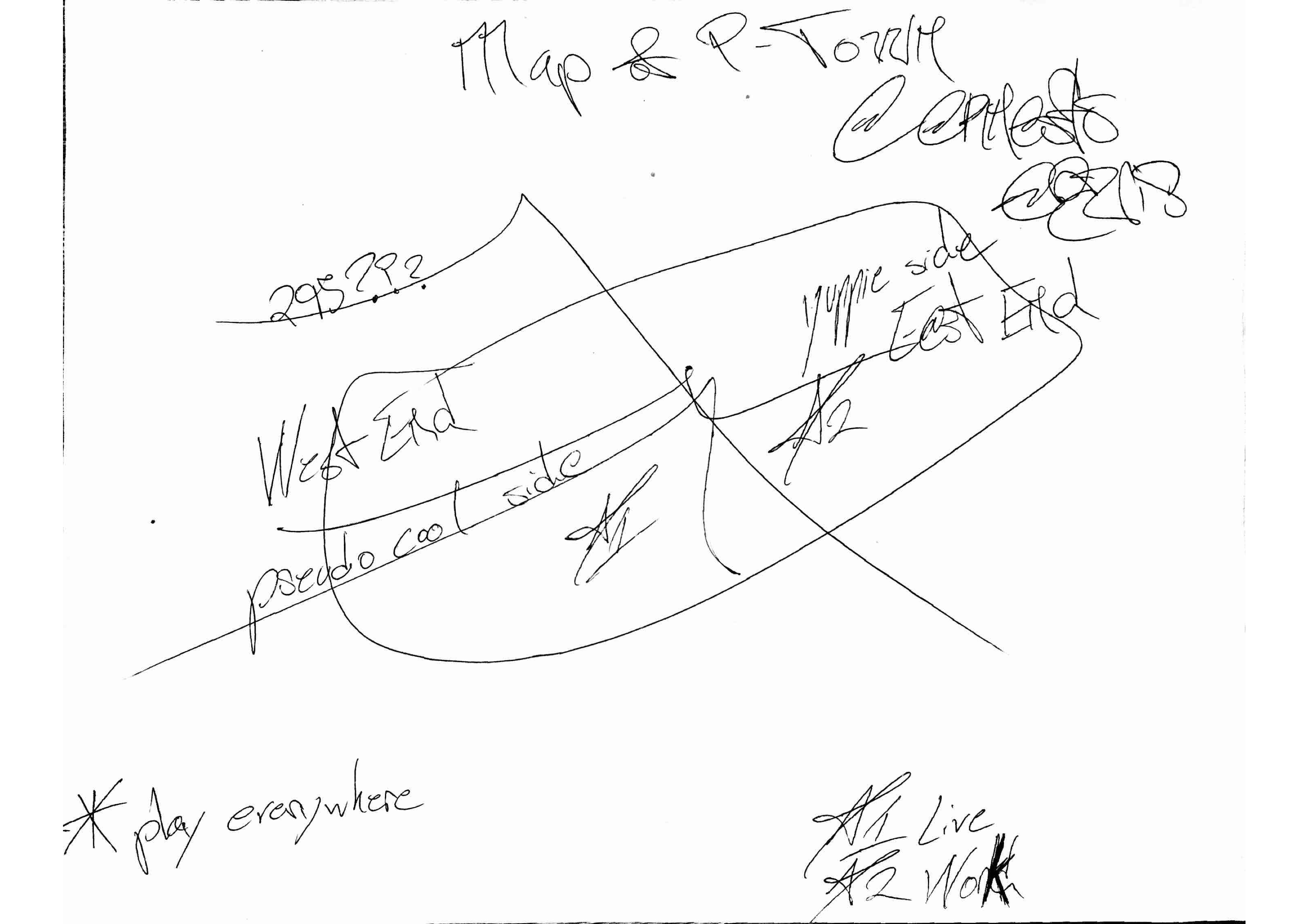
Map 1: Parker, 26, in Portland for 3 years, identifies as male, lives in South Portland, works in retail at the Maine Mall. [email protected]


Mental Map 1


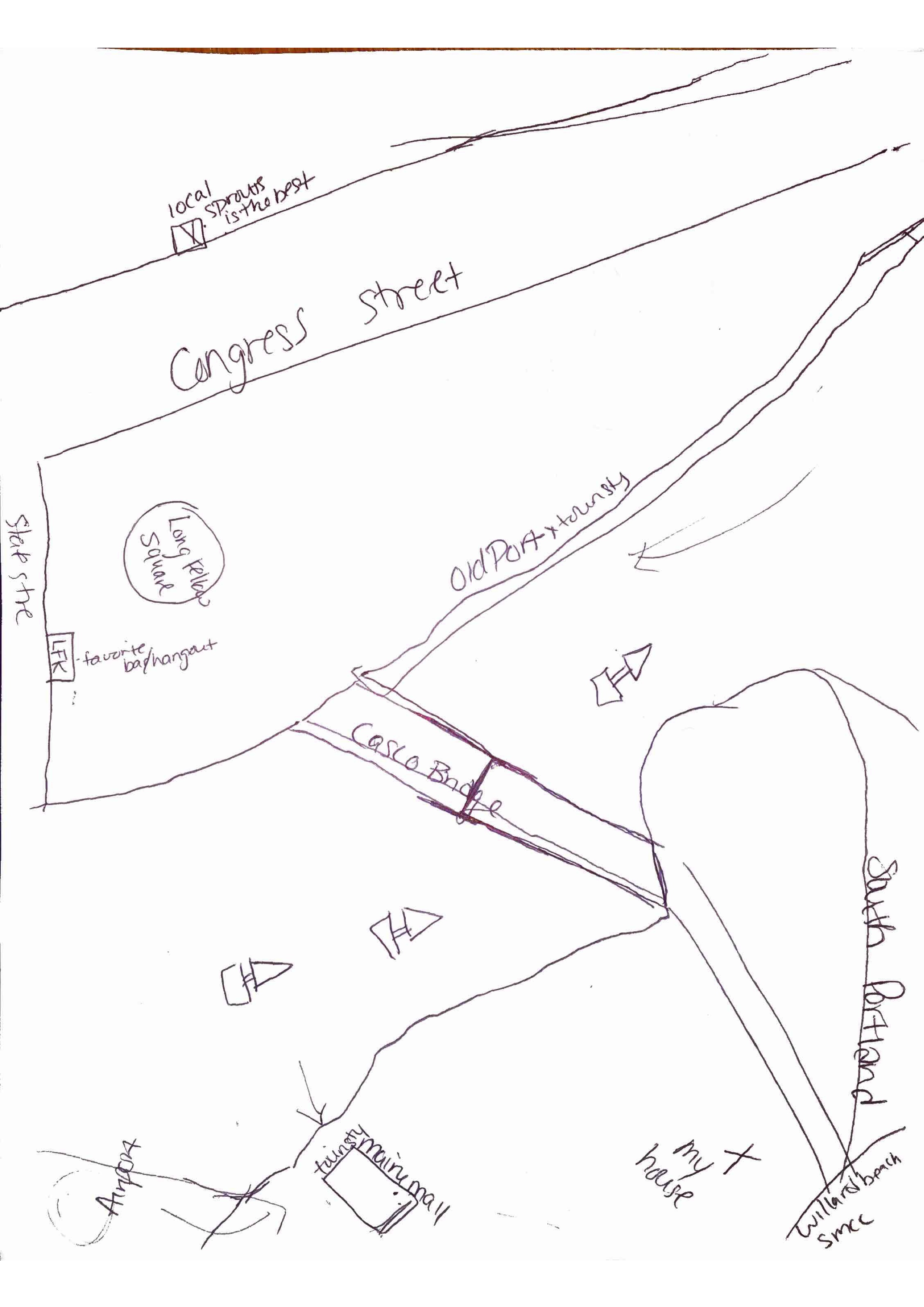
Map 2: Lahana Palehcia, 19, Female, Housekeeper, in Portland for 1.5 years, lives on Congress St, [email protected]. Uses the Portland Bus System extensively.


Mental Map 4


Map 3: 24, female, student, in Portland for 3 months, lives on High Street, wishes there were more public shuttles to get to wilderness areas.

Mental Map 3

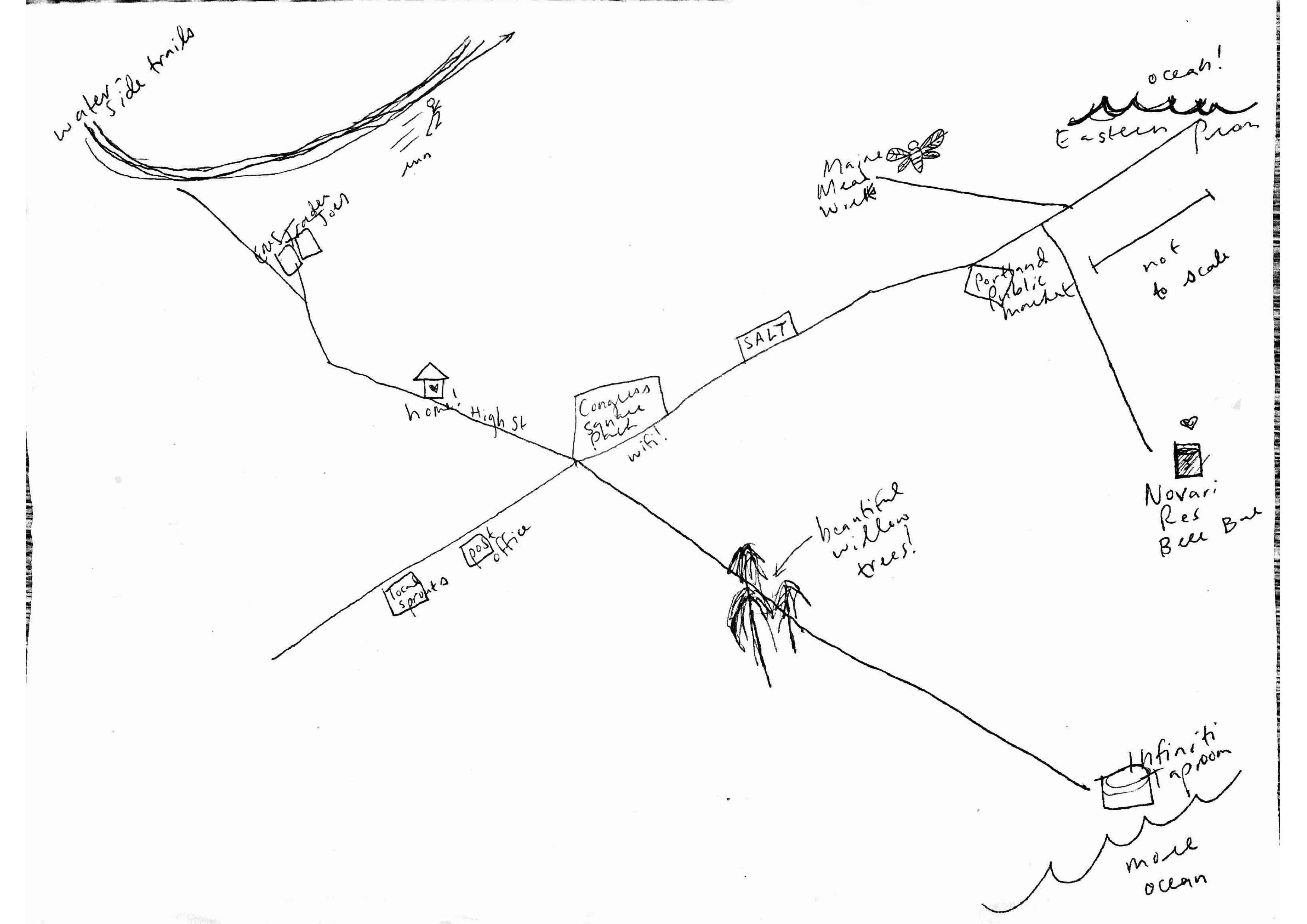
Map 4: Erneok Moreno, 32, male, in Portland for 2 months, lives in West End, [email protected].


Mental Map 2

OpenSource for Better Infrastructure

As cities grow and expand they are obliged to play catch-up with existing transportation technology, successively refitting themselves with systems that do not love them; urban space has been rent and scarred by railways and freeways, clogged and scored by pollution and metal.[1] As cities become smarter more and more layers of complex systems and technologies are built onto them; however, new technologies come at the price of diminishing public space.

As I have mentioned in my previous posts, we should not be judging how smart cities are just by the technologies that they implement. We can put all the technology we want into the city, but these efforts will be fruitless if people will not be able to live in it. A perfect example of this is Masdar City, it has all the imaginable technology but lacks the human character of cities that begins with face to face interactions.[2] Therefore, production of public space should be the central concern when developing infrastructure for smarter cities.

Open Source Urbanism described by Alberto Corsin Jimenez will be the most useful in promoting the common good, because it creates a system designed and managed by citizens eliminating the possibility of infrastructure serving the interests of a small group of people. The most exciting thing about open source urbanism is that in ensures high standards of produced infrastructure by implementing a recursive approach and preserving a permanent beta condition[3] i.e. always leaving room for improvement. Open source urbanism will enable us to create infrastructure that will better serve the needs of the community; Open source approach will also rule out the chance of encountering legacy systems due to the recursive improvement by people for people.

The transition to open source infrastructure is not going to be an easy one and it will definitely pose some challenges. One of the first things that will need to be done when implementing a large open source, peer-to-peer platform is reaching a consensus over methods, protocols, and standards;[4] this is will not only prevent the existence of incompatible systems but will enable us to create smart, universal systems capable of maintaining themselves by analyzing the data received from different parts of the infrastructure (as every part of the open source platform will speak the same language). Another thing that needs to be considered is the ease of making changes – in an open source project a community assumes political and expert management over its infrastructures – a mechanism controlling the ease of making changes will need to be implemented to protect the infrastructure from trolls that will try breaking the system just for the fun of it.

I think Portland could really benefit from the open source infrastructure and crowdsourcing ideas. Crowdsources data could be used by developers for creating efficient transportation apps that would be able to talk to the city infrastructure. Open source urbanism will spark innovation and create more incentive for city dwellers to actively participate in city life, knowing that their voices will be heard and their ideas considered.

——————–

Citations

1.Sorkin, Michael. 2014 [1999]. “Traffic in Democracy.” In The People, Place and Space Reader, edited by Jen Jack Gieseking, et al, 413. New York: Routledge, 2014.

2.Sorkin, Michael. 2014 [1999]. “Traffic in Democracy.” In The People, Place and Space Reader, edited by Jen Jack Gieseking, et al, 413. New York: Routledge, 2014.

3.Jiménez, Alberto Corsín. 2014. “The Right to Infrastructure: a Prototype for Open Source Urbanism.” Environment and Planning D: Society and Space 32 (2): 343.

4.Jiménez, Alberto Corsín. 2014. “The Right to Infrastructure: a Prototype for Open Source Urbanism.” Environment and Planning D: Society and Space 32 (2): 343.


Mental Mapping Script & Sample Requirements

In class, we agreed that all of our research participants must meet the following requirements:

  • Be age 18 or over
  • Max 1-2 are not from City of Portland
  • Min 1 year residence (not address) in Maine
  • Half female and half male (appearing)
  • Seek out diversity

Gather information after the interview by asking about:

  • Occupation
  • Length of residency
  • Neighborhood
  • Age
  • Gender
  • Why in Portland
  • Recommendation for the city

 Script for interviewing:

Hi, I’m ___________________, a student at Bowdoin College. I am taking a course entitled The Digital Image of the City and I need to speak to a few Portland residents. I need to speak to a few people and have them draw their map of the city. If you are a Portland resident and this interests you, do you have 15 or so minutes to chat with me?

IF NO:: Thank you for your time.

IF YES:: Great. Thank you.

Here is a piece of paper and some pencils and pens. The purpose of this exercise is to elicit how residents of Portland see and experience the city.

I will ask you to label this map as we go along and I will take notes as well for my memory. I will also ask you some basic questions about yourself to help us understand whose maps we are collecting.

Please sketch your map of Portland. We do not expect an accurate drawing, just a rough sketch; in other words, a mental map. Include the places and spaces you go on an everyday basis as well as those places and spaces that you think define the city.

[As person draws, student records order of places and spaces drawn and continues to ask research participant what they are drawing.]

WHEN MAP IS COMPLETE TO PARTICIPANT’S LIKING:: Thank you again for taking part in our study.

In order to help us keep track of who made which map, do you mind sharing the following information with us? Age? Race? Gender? Class? Occupation?

Thank you again. This concludes our study.


Blog Post #8: Policy Recommendations 2.0

Blog Post #8 – November 5th – due November 6th by 5 p.m.

For this post, imagine that your audience is the citizenry of Portland, including politicos, policymakers, stakeholders, business owners, and everyone else you can think up. It is time to turn to policy. In class on November 5th, we read NYC Digital: NYC Mayor’s Office of Media and Entertainment. Now that you had the opportunity to think through and critique the ideas in this document together in class, you will need to find a policy document from Portland related to your research area. (NOTE: Prof. Gieseking will help narrow your search with links to Portland policy documents). First, link the policy document and describe what you found therein. Then, drawing from at least two of the October and November readings and the NYC Digital report, where can the ideas you have been developing throughout the class fit into the policy as it now stands for Portland? Convince the people of Portland of your ideas.

Blog Post #7 & Comment #3: Transect Walk Data Sharing

Blog Post #7 – October 27th

Place the details from your transect walk into your post with exact notes of addresses or latitude and longitude. At the top of the post, reflect on what this data tells you about your research area, and how this data repeats or diverges what you found in your ethnography and mental maps. Are you swayed to consider different smart city recommendations to improve the quality of life and economic sustainability of Portland? Or have you different ideas in mind?

Comments #3 on Blog Post #7 – November 3rd

Continuing our work to produce knowledge as a group, look at each of Blog Post #7 for your research group. In a paragraph (or two maximum), respond to your colleague’s ideas and describe how this may or may not shift the ideas you have been thinking about. What else should your colleague consider? Draw on evidence from any of the class readings in October to back up your ideas.

Blog Post #6 & Comment #2: Ethnography & Mental Map Data Sharing

Blog Post #6 – October 27th

Carefully scan or photograph your mental maps (300dpi) and submit the originals to Prof. Gieseking’s box on the 2nd floor of the VAC in Martie Janeway’s office (under our classroom). Post your full ethnography and load and embed your mental maps into a post. At the top of the post, reflect on what this data tells you about your research area. Are you swayed to consider different smart city recommendations to improve the quality of life and economic sustainability of Portland? Or have you different ideas in mind?

Comments #2 on Blog Post #6 – November 3rd

It is now time to build on the knowledge you individually created and produce shared knowledge. Look at each of Blog Post #6 for your research group. In a paragraph (or two maximum), respond to your colleague’s ideas and describe how this may or may not shift the ideas you have been thinking about. What else should your colleague consider? Draw on evidence from any of the class readings in October to back up your ideas.