
“People as infrastructure” is a concept at the core of any healthy and thriving city. People are the most important part of the city—without them there is no culture, no community, no innovation, and reason for innovation to exist. There is no city without people. In all cities, people function as cultural infrastructure, and in some cities as even more.
In New York City (and around the world), people absolutely function as the infrastructure of city image. While the specific purpose of the infrastructure varies—be it image, black market, street art, punk rock— cities are filled with networks of people without whom a factor of the city’s life would crumple. Networks of people are the infrastructure of culture; in Johannesburg they are the infrastructure of life, as well.
In Johannesburg and other African urban centers, people function as infrastructure in a more day-to-day way. Without this form of infrastructure residents might not have electricity, food, clothing. [1] In smaller communities, “people as infrastructure” can function as the lifeblood of cultural expression and organization. New Brunswick, New Jersey is home to a thriving punk rock scene that operates through semi-legal underground punk shows in residential basements. The location of each show is kept secret except through connection to the New Brunswick network of punk-rockers.
The problem is that you can’t just make people into infrastructural systems. In Johannesburg the human infrastructure developed out of need. Short of dire need for infrastructure, some form of guidance or policy is necessary to create a system in which “people as infrastructure” can form. Essentially, physical infrastructure may designed so that there is room for “people as infrastructure” to fill it out and make it operate to fuller potential. Once it is decided who should “give ground,” [2] those on the ground have the potential to make the system run as well as possible.
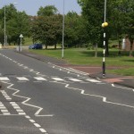
One of the best ways to make infrastructure work well, and traffic flow smoothly, is good communication between the moving parts. In London there are three different kinds of crosswalks: the zebra crossing where pedestrians always have the right of way, a smaller designated crossing where motorists always have the right of way, and a crossing controlled by traffic lights where the right of way is allotted to each. These crossings are not only well marked, they are well-conceived. They each fulfill a different and often site specific need in the city.
This crossing system, which relies on the knowledge and judgment of people, is a form of promoting “people as infrastructure.” People who know exactly how to use the city make it function better and more efficiently. This knowledge is helped along through government supported “people as infrastructure,” too. On the pavement at every busy crossing is written “Look Left” or “Look Right,” to keep disorientated pedestrians from being hit by cars. This kind of guidance helps modern city traffic to move as quickly as possible on roads that in some cases were originally built for Roman foot soldiers.
Portland is such a small city that it seems ridiculous not to privilege pedestrians in most infrastructure. Part of this might just be putting in infrastructure to make the city more pedestrian friendly. This includes well-marked, free public parking in useful places, so that people get out of their cars to walk. It includes enough public seating to make walking a realistic and attractive means of transportation. It includes considerations of sidewalk width and street crossings that help pedestrians to be comfortable.
Whatever the changes, a clearly marked system would be pretty necessary for success since so many of the Portland’s summer pedestrians are tourists. Everyone can benefit from a little more clarity in public directions, though.
[1] Simone, AbdulMaliq. 2014 [2004]. “People as Infrastructure: Intersecting Fragments in Johannesburg.” In The People, Place and Space Reader, edited by Jen Jack Gieseking, et al, 245. New York: Routledge.
[2] Sorkin, Michael. 2014 [1999]. “Traffic in Democracy.” In The People, Place and Space Reader, edited by Jen Jack Gieseking, et al, 411. New York: Routledge, 2014.
[3] Britton, Ian. Pedestrian Crossing. Digital image. Freefoto.com. N.p., 2 June 2007. Web. 8 Oct. 2014.
[4] Screenshot from Google Maps, from post code W10 in London, UK. Coordinates for Google Maps [51.525564,-0.214748]
[5] London Crosswalk Countdowns. Digital image. Jocabola.com. N.p., n.d. Web. 8 Oct. 2014. <http://www.jocabola.com/archives/blog/london-crosswalk-countdowns/>.