
Improving Portland’s Public Bus System
Konstantine Mushegian
The Digital Image of the City – INTD2430
Professor Jen Jack Gieseking
Abstract
This paper addresses the issue of public transportation in Portland, Maine and offers smart city solutions and policy recommendations that will improve the existing transit system. Technological solutions and policy recommendations proposed at the end of this paper will aim to reduce commute times through the intelligent bus stop placement. Optimal bus stop locations will reduce the average walking time to the bus stop, thus making the public transportation system more accessible and attractive for residents and visitors alike. Portland’s Comprehensive Plan website has only one document that addresses the issues of public transportation in and around the City of Portland. “A Time of Change: Portland Transportation Plan” was proposed to the City Council in July of 1993 by a “Committee of Citizens” [1] but the majority of issues brought up in the plan still seem to exist, almost twenty-two years later. The plan to overhaul Portland transit system that was put together by citizens addresses and tackles issues of intra- neighborhood and inter-neighborhood transportation but no significant changes have been made since 1993. The fact that nothing of importance has been changed is also reinforced by the fact that the only document on the Comprehensive Plan website that touches upon the issues of public transportation is from 1993. I have been regularly reading the minutes from the meetings of the Portland City Council Committee on Transportation, Sustainability and Energy (TSE) for the past couple months. The issue of bus stop placement was brought up at the TSE meeting on September 27, 2014 and a request for proposals was issued in the same month for a Hub Link Feasibility Study in order to “evaluate feasibility of transit routes which will best improve connections between local and regional transportation terminals and major points along the corridors connecting them”[2] but no proposals were received by the deadline of October 17th.

The lack of proposals indicates the inactivity and nonchalance of residents and commuters who are affected by the issue the most. In addition, I will also offer suggestions on how to improve citizen involvement in public issues in this paper.
Approach to the Common Good
Throughout this class we have talked a lot about the commitment of the smart city to the common good, but what does it exactly mean? Common good is a very interesting concept, it is easy to see how it works in a smaller community but it might be hard to understand how it is going to work in a city. Often times common good is confused with just giving back to the community, but “it’s about looking forward and connecting who you are and what you can do to a greater purpose.”[3] I do not think that any city can start committing its actions to the common good right away; dedication to this idea should start from the bottom. The smartest thing that the City of Portland can do in order to foster the commitment to a “greater purpose” is to start creating a sense of responsibility and community among residents. It is extremely important to establish citizens rather than a city as a main contributor to the communal well being in order to avoid unrealistic expectations from the city government. Citizens include both residents and commuters because Portland issues affect both of categories more or less equally. Thus, citizens, residents and commuters alike, should be contributing to economic, social and cultural advancement of the community. The contributions do not have to be financial or tangible and can take any form, ranging from crowd sourced data to some sort of art work to utilizing open source databases for developing applications that will make lives of other citizens easier, and the city itself a better place.
Common good is a constant cycle of giving and getting back. A city based on the concept of the common good is going to succeed because it will unite people under a shared goal. Common good will also create a tighter community; people in large cities tend to isolate themselves, but Portland is still small enough that it is possible to avoid and hopefully change this tendency. In a smart city private companies, city government and citizens will all be working towards a common goal and there will be no place for divide. Smart cities can and will form strong communities where people care and stand up for each other.
Approach to the Smart City
Most cities were not designed to be smart. In fact, most cities were not designed at all. Cities are born more often that not without a plan; they shape themselves as they need to and when they need to. It is a great luxury to be able to design a city from scratch. This issue is the most pressing in Europe where cities have existed in the same places for hundreds and even thousands of years, slowly growing and spreading without forethought but out of necessity. Predominantly it is only cities in the United States that have had the luck and luxury of being planned and designed, because the creators of the Commissioners’ Plan of 1811 had the experience of European cities to rely upon.
Urbanization has been on the rise for the past decades, and as more people move into cities it is crucial to make systems supporting them as efficient as possible. It is difficult to thoroughly define the concept of a “smart city” because it is relatively new. A smart city takes a more intelligent, more efficient approach to transportation, energy, resource allocation and etc. by using digital technologies for performance optimization. However, as cities grow and expand, introducing new technology and infrastructure becomes harder and harder because of the pre- existing layers that are often times impossible to remove. Such layer complexity results in adding more and more layers of complex systems and technologies on top of each other, which is a very dangerous process. We can already see what careless addition of layers has done to the Internet. Paul Kocher, one of the leading cryptographers says that the problem is a lack of liability and urgency:
The Internet is still largely held together with Band-Aid fixes. Computer security is not well regulated, even as enormous amounts of private, medical and financial data and the nation’s computerized critical infrastructure – oil pipelines, railroad tracks, water treatment facilities and the power grid – move online.[4]
As we move towards smarter cities and more and more individual citizen data goes online, keeping this information secure is becoming more and more important. More and more companies will be willing to collect data and no one knows how all of the different sensors will work together. Michael Sorkin perfectly sums up what happens to cities when they grow and expand in his 1999 article “Traffic in Democracy”:
As cities grow and expand they are “obliged to play catch-up with existing transportation technology, successively refitting themselves with systems that do not love them; urban space has been rent and scarred by railways and freeways, clogged and scored by pollution and metal.[5]
It is extremely important that we choose an intelligent approach to rebuilding Portland as a smart city. We need to be especially careful when choosing how we implement smart city systems, so that people who come after us will be able to add new layers of technology without creating mess and disorder in already complex systems. It is principal that we account for improvements and modifications that will need to be done in the future in order to keep the city up to the latest technology standards.
Smart cities are often associated with CCTV cameras and sensors tucked into every corner, tracking actions and movements of every citizen. Such images scare people and make them less likely to support the implementation of core smart city systems. It is crucial to educate citizens about what smart cities aim to do and that implementation of data collection devices will not result in constant spying. Deployment of information gathering systems will need accompanying policies that will make sure that no individual citizen data is collected without permission. These policies will have to outline the kind and amount of information that will be collected and measures that will be taken to remove any identifying information from the collected data before storing it forever in server farms.
Another measure that will eliminate the possibility of the illegal activity of spying is making collected data (or at least most parts of it) open to the public in one form or another. The open source system will increase the trust of citizens and also inspire innovation, as every developer will be able to utilize the collected data to create something new or improve an existing technology. Data collection has existed for years and still exists but it is a process not open to the public. The transition to open source infrastructure and information collection system is not going to be an easy one and it will definitely pose challenges. One of the first things that will need to be done when implementing a large open source, peer-to-peer platform is “reaching a consensus over methods, protocols, and standards.”[6] This will not only prevent the existence of incompatible systems and data formats, but will enable us to create smart, universal systems capable of maintaining themselves by analyzing the data received from other parts of the smart city infrastructure (as every part of the open source platform will speak the same language). This type of smart city infrastructure will be the most useful in promoting the common good, because it will involve every citizen in the process of designing and managing the data. Another exciting thing about open source urbanism is that it ensures high data standards by implementing a recursive approach and preserving a “permanent beta condition”[7] thus always leaving room for improvement. Alberto Corsin Jimenez further describes the methods I have proposed in his article “The Right to the Infrastructure” and unites them under the term of Open Source Urbanism.[8]
Literature Review
Cities are an intricate social phenomenon; they unite a huge amount of people who do not know each other on tiny pieces of land and force them to interact on a day-to-day basis. City life is something one must experience for oneself, Iris Marion Young describes it in the best possible way: “By ‘city life’ I mean a form of social relations which I define as the being together of strangers.”[9] You might not realize what Young is talking about if you have never lived in a city, but if you have think of all the random conversations you have had with strangers in coffee lines or on the contrary all the times that you have tried avoiding eye contact with every person. There are many interesting of city life, but the most important part of it is that people are on the moves at all the times, and this is why I chose public transportation as a focus of my research.
City life is a vast, even infinite, economic network of production, distribution,transportation, exchange, communication, service provision and amusement.[10]
People need to move around and transportation becomes crucial to development in this case. Portland is still small enough that we can easily change a lot of things without causing major disruptions. It is very important to start developing Portland intelligently while it is still small in order to prepare it for its big city days.
The goal of my research is to come up with optimal and most efficient bus stop locations in Portland, Maine in order to make public transportation as attractive as possible to residents and visitors. There are a couple of things to be considered when choosing locations for bus stops, but the most important factor is the distance between successive stops. Stop locations cannot be too far away from each other as that will make the routes impractical, but they cannot be too close to each other or else the routes will become very slow. Frequent acceleration and breaking will also result in the inefficient fuel consumption. Michael Sorkin points out that “pedestrians are disadvantaged”[11] in modern cities, but they are also the most important component of them. I will try to understand the city from the position of a pedestrian, rather than “from the position of the car”[12] when developing my final recommendations. We can build as many roads, routes and bus stops as we want but our efforts will be pointless if people will not be able to use them. We should be tailoring infrastructure to the city, instead of making the city fit the infrastructure.
Wiransighe and Ghoneim who took a mathematical approach for calculating the most efficient distances between bus stops. They came to a conclusion that “an upper bound is 0.37 km, and a lower-bound 0.22 km.”[13] Bus stops placed in this pattern will be close enough to increase accessibility from most points along the route, but also far enough to make taking a bus efficient. Wiransighe and Ghoneim also point out that “bus-stops have to be spaced a certain minimum distance apart to give passengers time to ring the bell, get up and walk toward the door etc. This minimum spacing can be converted to a maximum (limiting) density of stops.”14
I have tried searching media sources like The Verge, Engadget, TechCrunch and Mashable with the following queries: “bus stops”, “public transportation.” The search results did not turn up anything related to the issues of bus stop placing and spacing or the efficiency of current public transportation systems. The search results did however turn up very interesting articles about smart technologies that can be implemented in buses and bus stops, like “real time map and empty seat displays”[15] and applications that will “wake you up when you’re close to your bus stop.”[16] All of these ideas are very interesting and would definitely be worth implementing in Portland, Maine; however, they do not have anything to do directly with the issue discussed in this paper thus I will not spend a lot of time discussing them here.
Methods
We randomly selected 100 people in Portland, Maine for our research. Our goal was to interview both residents and commuters in order to get a wider perspective on issues of Portland so that we could consider a multitude of views when developing final policy and smart city recommendations. We used three methods of data collection for our research. I also used the data provided by Professor Gieseking and the U.S. Census Bureau.
Café Ethnography
The goal of this method was to “catch a glimpse into the everyday life of Portland, Maine from inside a local business with a view of the city’s streets.”[17] I chose Coffee by Design located on India Street for my café ethnography. I documented the dynamics of the café every 10 minutes and was able to find a number of intriguing results. It was very interesting to see how the age of visitors changed over the course of a day. I noticed that the age of visitors was higher in the late morning/early afternoon. I also made another, very curious observation: younger people, who happened to be at the café alone, used their phones all the time, while older people were chatting with each other or reading printed newspapers and books.
Mental Mapping
We asked our respondents to draw their mental maps of Portland, Maine in an attempt to see the city through their eyes. Interviewees mostly put places of personal importance on their maps, which was expected. It is significant to note that mental maps of the same city varied based on age, profession, gender and etc. After mental maps were gathered, all of the personal identifying information was removed and maps were uploaded to the course website so that other students could look at them and use them for their research.
Transect Walk
Transect walk is a “a tool for describing and showing the location and distribution of resources, features, landscape, main land uses along a given transect.”[18] Each student had to choose one element or issue to look for throughout the walk. I spent about 3 hours walking along and around Commercial and Congress Streets looking for trashcans. The goal of my transect walk was to find out how the quantity of trashcans is affected by a neighborhood. I found out that the average distance between trashcans in areas frequented by tourists is approximately 150 feet, while in areas that are primarily used by residents and commuters, this number goes up to 500-600 feet. I recorded the latitude and longitude of every trashcan I came across and then created a custom Google Map where I mapped recorded coordinates, as well as parks and plazas that had no trashcans in them but definitely should.
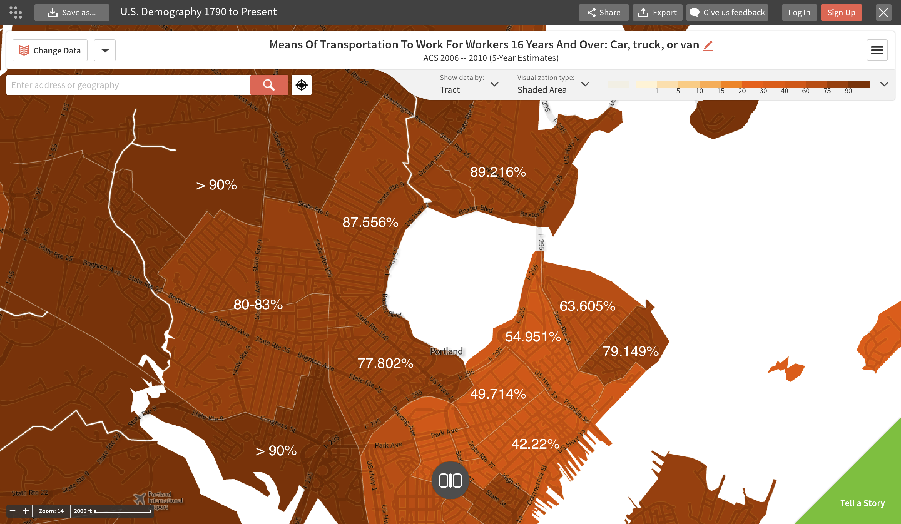
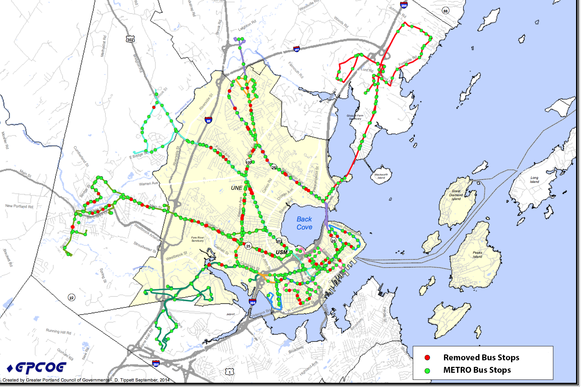
I was initially going to focus my research on the location of trashcans and how trash moves, but I realized that this requires much more resources than I have access to. Instead, I looked at a map of bus stops and routes in Portland, Maine to visualize the existing situation and come up with optimal locations for new bus stops while considering such factors as accessibility, proximity to major origins/destinations and also route optimization. I realized that having too many bus stops close to each other makes routes slow, but having them too far apart call the efficiency of the route into question. I edited the map provided by Portland METRO to represent the proposed location changes. I also looked at U.S. Census data available on Social Explorer to find out what percentage of the Portland population relies on public transportation. As it turns out, only 12% in downtown Portland rely on the public transit system; this number goes down to 2% in the surrounding areas, including South Portland.

However, over 50% of the population relies on cars, vans and trucks for transportation; this number floats around and above 90% outside of downtown.
Reflections and Suggestions
There are currently 800 bus stops in the Greater Portland Transit District some of which will need to be relocated or removed in order to increase route efficiency and improve transit travel times. The easiest way of improving the average speed of Portland’s public transportation system is to balance out the walking distance with bus travel time. I closely analyzed the map of current Portland bus stops; it is quite easy to see that bus stops in the Greater Portland Transit District are not optimally placed.

Some of the stops are very close too each other, which results in slower routes. For other routes, bus stops are too far apart, which makes taking a bus inefficient: bus stops should be close enough that a passenger will not have to take a long walk after getting off the bus. This should be kept in mind when adding new or relocating existing bus stops in order to increase customer satisfaction and the attractiveness of given routes.
There are many factors that need to be considered when deciding on new bus stop locations such as accessibility, proximity to major locations, route optimization, safety, accessibility for people with disabilities and smart technologies that can be implemented in buses and bus stops to make user experience better.
It is easy to notice that the number of bus stops on major streets is higher than on secondary ones, which is understandable. However, we should consider placing more bus stops on side streets in order to increase accessibility for residents, because housing is very rarely located on central streets.
Proximity to major origins and destinations is another important factor. It is critical to make the walking distances to and from bus stops as short as possible. I think this will significantly increase ridership along with customer satisfaction, as citizens will be more inclined to take a bus instead of using private cars or cabs.
Route optimization is one of the most interesting and hardest problems because it offers the most advantages. The optimal route has the shortest distance but the largest coverage (streets, bus stops, major locations). This problem is known as a “Travelling Salesman Problem” (TSP) in computer science and it asks the following question: “Given a list of cities and the distances between each pair of cities, what is the shortest possible route that visits each city exactly once and returns to the origin city?”[19] Unfortunately TSP is NP-Hard and has not been solved yet. Minimizing the travelled distance while maximizing the covered points will result in the reduction of fuel costs and transit times. However, since there is still no solution for an optimization problem of this kind, I think it would make most sense to invest into the bus fleet. Increasing the fleet size will be expensive but it will pay off in the long run, because more and more people begin to rely on buses for transportation thus bringing in more and more revenue.
Passenger safety is also one of the major concerns. Placing bus stops on street corners make sense in terms of increasing accessibility, but it also multiplies the chance of traffic accidents because street corners are hazardous locations by themselves. I think a reasonable decision will be to invest more into bus stops and place them on both given streets.
Increasing accessibility for people with disabilities and making their integration into the society as seamless as possible is also very important. I realize that installing ramps/lifts at every bus stop is going to be expensive, but I think installing them at every other or every third bus stop should be reasonable. This will make the best top an accessible place for those with disabilities and thus make buses an attractive form of transportation to people with disabilities.
There are a bunch of smart technologies that can be placed into buses and bus stops. Some of the buses in London now have a real time empty seat displays that make finding an empty seat significantly easier. Such system would be fairly easy to implement by placing pressure sensors into seats. Bus stops in Tbilisi, Georgia have digital screens with detailed destinations and exact arrival times. This is very convenient, because sometimes it makes more sense to walk if the bus is not going to arrive for another 10-15 minutes and thereby places more decision making power in the hands of commuters.
I know that some of my colleagues have been working on ideas of implementing free public Wi-Fi in Portland, Maine using the old fire call boxes as routers. This is a great idea and it will work perfectly fine for pedestrians; however, people riding the bus will have to switch from one router to another rapidly, which takes time and results in dropped connections. In order to avoid signal drops, I would suggest installing Wi-Fi routers on buses that will provide constant Internet access to passengers during the entire trip. This will also be fairly easy to implement, because buses will need Internet connectivity for displaying ETA on bus stop screens.
All of the proposed solutions will need to be accompanied by policies in order to ensure their complete execution and implementation. Policies could take a form of standards outline for distances between bus stops or from street corners and etc. Creating accompanying policies will guarantee the proper execution of proposed recommendations and make sure commuters are happier with their experience of public transportation
Conclusions
Out of 800 existing bus stops, approximately 80 stops will need to be removed or relocated in order to create a faster and more efficient public transit system. (See Figure 5)
Relocation and removal will increase accessibility and improve user experience and satisfaction by putting the bus stops where they are needed the most. Proposed changes will tackle the issues of safety, efficiency, accessibility and client comfort. All of the suggestions will be accompanied by public policies to make sure that private companies are following the established standards and guidelines. It is critical that guidelines are followed thoroughly because a smart city system is truly smart when all of its parts are fully optimized. This is a basis of a smart city concept: all systems working in unison towards a shared goal of creating common good.
———————————————————————
Citations:
1. Committee Of Citizens. “A Time Of Change: Portland Transportation Plan.” July 1, 1993, 3.
2. Christine Grimmando, Senior Planner. “Hub Link Feasibility Study.” Sustainability & Energy Committee, November 12, 2014, 1.
3. “Common Good.” Bowdoin College. Accessed December 13, 2014. http://www.bowdoin.edu/academics/common-good/.
4. Perlroth, Nicole. “Hacked vs. Hackers: Game On.” Bits Hacked vs Hackers Game On. December 2, 2014. Accessed December 13, 2014. http://bits.blogs.nytimes.com/2014/12/02/hacked-vs-hackers-game-on/.
5. Michael Sorkin. “Introduction: Traffic in Democracy.” In The People, Place, and Space Reader, edited by Jen Jack Gieseking, et al. 411-415. New York: Routledge, 2014.
6. Jiménez, Alberto Corsin. “The Right To Infrastructure: A Prototype for Open Source Urbanism.” Environment and Planning D: Society and Space 32 (2014): 343. Accessed December 13, 2014. http://bit.ly/1snvfGO.
7. Jiménez, Alberto Corsin. “The Right To Infrastructure: A Prototype for Open Source Urbanism.”
8. Jiménez, Alberto Corsin. “The Right To Infrastructure: A Prototype for Open Source Urbanism.”
9. Young, Iris Marion. “City Life and Difference.” In The People, Place, and Space Reader, edited by Jack and Et Al Gieseking, 249. New York: Routledge, 2014.
10. Young, Iris Marion. “City Life and Difference.”
11. Michael Sorkin. “Introduction: Traffic in Democracy.”
12. Michael Sorkin. “Introduction: Traffic in Democracy.”
13. WIRASINGHE, S. C., and NADIA S. GHONEIM. “Spacing of Bus-Stops for Many to Many Travel Demand.” Transportation Science, August 1, 1981, 210-21.
14. WIRANSIGHE, S.C. and NADIA S. GHONEIM. “Spacing of Bus-Stops for Many to Many Travel Demand.”
15. Brian, Matt. “Smart London Buses Get Real-time Map and Empty Seat Displays.” Engadget. June 23, 2014. Accessed December 14, 2014. http://engt.co/1pPeuOE.
16. Fingas, Jon. “Android Can Now Wake You up When You’re Close to Your Bus Stop.” Engadget. June 8, 2014. Accessed December 14, 2014. http://engt.co/1zbirE8.
17. Gieseking, Jen Jack. “Portland Research Assignments.” The Digital Image of the City. September 20, 2014. Accessed December 13, 2014. http://bit.ly/1uBa1Q2.
18. “Tool Name: Transect Walk.” The World Bank. http://bit.ly/1xlAkk6.
19. Cormen, Thomas H., Charles E. Leiserson, Clifford Stein, and Ronald Rivest. “NP- Completeness.” In Introduction to Algorithms. 3rd ed. Cambridge, Mass.: MIT Press, 2009.