
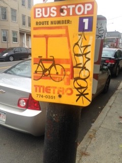
I conducted my transect walk with Karl and Rachel and we decided to walk through the East end. As we are all in the infrastructure group, we chose to focus on public transportation, and for our route we elected to follow and observe the #1 bus route. As I mentioned in my #6 post, the people of Portland deeply want a better public transportation system, and after conducting this transect walk, I completely agree with the people I talked to about public transportation. Some important and practical changes that should be made our shelters at each bus stop ( this will become very important in the winter time). Currently most stops, except for the last stop, only have signs on post to indicate where the bus will stop such as this one:
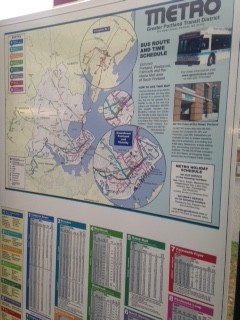
Additionally, a sign that contains the time in which the bus will come by is also necessary. This will aid in making the bus system seem much more reliable. The only shelter and bus schedule that Rachel, Karl and I found was on North Street in front of the East Community School.

Further, a smart city suggestion for Portland public transportation is to create an app that contains stop information, maps and updates about the bus (such as whether or not the buses are running behind), similar to the NJ Transit Schedule or MTA map you can find in App form. This will be helpful as more and more people are relying on their smart devices to get them from location to the next.
On our walk around the East Promenade it was pretty residential and as we got closer and closer to the water, the view became more and more unreal. Creating a bike lane could help reduce car traffic and pollution. We did see one on Congress Street, however, it only went for a few blocks until we ran into St. Lawrence Street. City of Portland is very small and can be walked across in just few hours; the city should use this to their advantage and try to turn Portland in to a walking city. A reliable public transportation system is key, as are bike lanes.
After walking this path, I see why many people are frustrated with the public transportation system(or rather lack there of public transportation system). Along with the need for in public WiFi in cafés, free public WiFi in all public spaces would greatly help the bus system. Smart city recommendations along with more practical solutions would vastly improve the quality of life and economic sustainability.
Full Transect Walk:
206 Congress Street (43.663676, -70.250266)
Sheridan and Congress Street (43.664660, -70.249350)
Turned onto Atlantic : Next stop is at Atlantic and Monument Street (43.6653356,-70.2457624)Intersection of Atlantic and Wilson (43.6653512,-70.2453279)
27 Atlantic (43.664808, -70.244244)
Turned onto Eastern Promenade(43.664195, -70.243182): Next stop is at E. Promenade and Vesper (43.665382, -70.241702)
126 Wilson Street and E.Promenade (43.667571, -70.242227)
182 Congress Street and E.Promenade (43.668797, -70.244094)
Turner Street and E.Promenade (43.669604, -70.245639)
304 McAuthur Gardens and E.Promenade (43.670706, -70.249062)
Turned onto North Street: Next stop is at East End Community School on North Street (43.671226, -70.254072)
143 North Street(43.669674, -70.252495)
Intersection of Quebec Street and North Street (43.667417, -70.250051)
Intersection of Cumberland Street and North Street (43.666122, -70.248668)
Totally agree with your thoughts on the bus system. Theoretically I like the idea of GPS tracking and an app for the bus system, but I think there are technological difficulties we do not know about. Consider the Saferide public transport system at Bowdoin that students always seem frustrated with; why hasn’t a student developed the same type of app you suggest for Portland busses? If it were a simple task, I would hope Bowdoin could act as a test subject and possibly funding partner with Portland to get the system into as many public transportation systems as possible.
I agree entirely with you on revamping the bus system. The Portland bus system is sporadic and does not reach the areas of Portland that it should. The signage for the bus system is not helpful to people who might want to take the bus. On top of that, the buses do not run nearly as often as they are supposed to. This makes it almost impossible for commuters into Portland to use the bus system. An app would definitely streamline the bus system quite a bit, as then people would know when to expect buses and what routes each bus will take.
Since I conducted the transect walk with you, I hold many of the same thoughts and sentiments. I did not think too much about the creating of a smart app for residents, but it was certainly something I was considering subconsciously. I think that a synchronization between said app and some type of technology on the bus that lets riders know where they are really helpful. Also, the app could be used to let interested riders know if their bus is running late. I bet that many riders do not use the bus system because it is often not on time and it is unclear when a bus will arrive. If the app could somehow let riders know when the bus will be at each stop (approximately), perhaps there would be increased ridership. I also thought there should be fewer posted stops, but that every stop should have some sort of shelter like the one that we saw.
Everything has pretty much been already said in the above comments and in posts by other people. Redesigning the bus system is important. However, to go further with this particular recommendation, I think it is imperative to study the current system and find current usage data/metrics to figure out precisely where needs to be changed and by how much. If not available online, these data could also be acquired through field sampling methods.